
BALDY - Archive of Mt. Baldy-related Discussions

The Sierra Club Ski Hut is not part of the Mt Baldy Ski area.
Nunc est bibendum
-
EManBevHills
- Posts: 387
- Joined: Fri Sep 28, 2007 12:40 am
Rumor has it that the new crapper site was selected based on instructions received in an Aetherian summit channeling.
-
BiletChick

- Posts: 22
- Joined: Fri Jan 29, 2010 12:52 pm
We just had a discussion about that very thing when we climbed the bowl in April. We were running a little low on water as we aproached the hut (which was locked on our way up). I thought about filling up from the spring, but luckily Kurt Wedberg (SMI) had opened the hut and we were able to tank up there. I wouldn't take a chance on the stream below the toilet, even with a filter and Steri-pen...
I'm not sure how that outhouse holding tank was constructed or who would empty it, but it was pretty full on Sunday! LOL
Stacy
I'm not sure how that outhouse holding tank was constructed or who would empty it, but it was pretty full on Sunday! LOL
Stacy
years ago when the Sierra Club had a work day at the hut and the outhouse, i asked how much longer till the "hole fills up?" referring to the "hole" under the outhouse. a guy answered that it never will since they apply yeast to breakdown the human waste. i was a bit stunned and really hadn't given it much thought since then.
Drinking from the spring is the same thing as drinking from the tap in the hut--there is simply a pipe connecting the two. In the old days the water used to run continuously through the hut sink and was discharged into the stream below. It's interesting that people will drink without hesitation water from the tap, but yet feel the necessity to treat the spring water.BiletChick wrote:We just had a discussion about that very thing when we climbed the bowl in April. We were running a little low on water as we aproached the hut (which was locked on our way up). I thought about filling up from the spring, but luckily Kurt Wedberg (SMI) had opened the hut and we were able to tank up there. I wouldn't take a chance on the stream below the toilet, even with a filter and Steri-pen...
I'm not sure how that outhouse holding tank was constructed or who would empty it, but it was pretty full on Sunday! LOL
Stacy
-
BiletChick
- Posts: 22
- Joined: Fri Jan 29, 2010 12:52 pm
Hi Dave,
I was refering to filling up from the spring above the hut. It was still covered up with snow, so I know it was pretty safe to drink unfiltered. Although, once I did see a woman of the Asian persuasion coming out from behind a bush about 2 feet from the water's edge...luckily the hut was locked up that day!
I got the hut/spring plumbing history from Tracy (hut host) the first time I was there in March. Due to the amount of snow below the hut, I didn't realize that the outhouse was sitting directly on the path of another stream.
I could only imagine an inexperienced hiker, short on water, coming up the trail tired and thirsty: "Wow, a stream! Cold fresh water, gulp!"
Then he/she gets to the hut, uses the facilities, puts two and two together...UH OH, too late now!!!
You have to wonder about these things.
-
OutdoorAbstract
- Posts: 32
- Joined: Thu Jan 22, 2009 4:43 am
I did the loop up the Ski Hut trail and down the Backbone five days in a row, does that count? Okay, it was only once per day but each RT only took me about 5 hours...
Anything?
Okay, I'll keep trying.
Anything?
Okay, I'll keep trying.
-
EManBevHills
- Posts: 387
- Joined: Fri Sep 28, 2007 12:40 am
I am cleansing my possessions of relics.
In the process, I game across a gem:
A photo of Wilson Harvey and RJ Secor (pre accident) at the Baldy ski hut. They are with Jim Hargear, an office colleague of mine who introduced me to this extraordinary mountain, and who is responsible for my meeting Will, who was to become my primary wilderness adventure partner.
Wilson probably held the record for most ascents of Mt. Baldy, until recently.
We celebrated his 80th on the mountain!
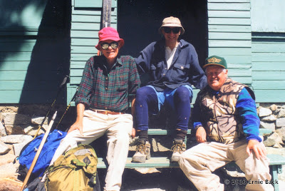
FWIW, Will believes he is in excess of 500 summits...He's unsure of the early years!
In the process, I game across a gem:
A photo of Wilson Harvey and RJ Secor (pre accident) at the Baldy ski hut. They are with Jim Hargear, an office colleague of mine who introduced me to this extraordinary mountain, and who is responsible for my meeting Will, who was to become my primary wilderness adventure partner.
Wilson probably held the record for most ascents of Mt. Baldy, until recently.
We celebrated his 80th on the mountain!
FWIW, Will believes he is in excess of 500 summits...He's unsure of the early years!
-
seadweller
- Posts: 48
- Joined: Thu Feb 28, 2008 9:28 am
Hi folks,
I have been up Baldymany times and also many times on the West Baldy peak and most of the times, I take the SKi Hut Trail ....
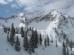
What I can not put in perspective is where is the Baldy Bowl when I see Mt Baldy from LA? or lets say from the beach? All I see is large grayish surface and I do not know where the SKI HUT trail is ...
Does someone have aerial shots or can put things in perspective for me?
Like take the classic shot of Baldy on a postcard and point out where devil's backbone is and where ski hut trail is?
thanks,
seasdweller ...
I have been up Baldymany times and also many times on the West Baldy peak and most of the times, I take the SKi Hut Trail ....
What I can not put in perspective is where is the Baldy Bowl when I see Mt Baldy from LA? or lets say from the beach? All I see is large grayish surface and I do not know where the SKI HUT trail is ...
Does someone have aerial shots or can put things in perspective for me?
Like take the classic shot of Baldy on a postcard and point out where devil's backbone is and where ski hut trail is?
thanks,
seasdweller ...
Baldy Bowl is southeast-facing; when you are in LA or at the beach, you are looking at the southwest face of the mountain.
Download Google Earth and play around with it.
Download Google Earth and play around with it.
Nunc est bibendum

-
seadweller
- Posts: 48
- Joined: Thu Feb 28, 2008 9:28 am
Thank you for the pics and info.
I do recall that as I am going up on the Ski Hut Trail, lets say about
50-100ft below the summit, I looked towarrds my left and I did see the
skyscrapers of down town LA ....you can see that entirre cluster from the position/location I described ....
Has anyone else seen them from this vantage point? That is downtown LA isn't it???
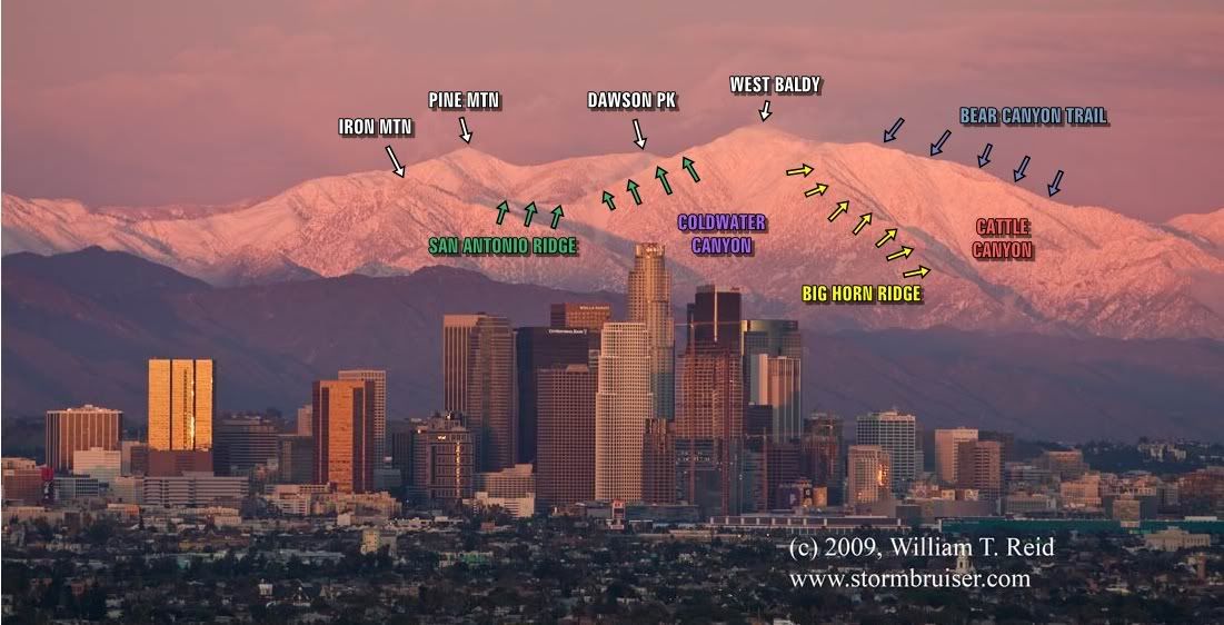
So if that is true, then the Ski Hut Trail must be to the right of the buildings shown in the postcard above by Tim ...
thanks,

I do recall that as I am going up on the Ski Hut Trail, lets say about
50-100ft below the summit, I looked towarrds my left and I did see the
skyscrapers of down town LA ....you can see that entirre cluster from the position/location I described ....
Has anyone else seen them from this vantage point? That is downtown LA isn't it???
So if that is true, then the Ski Hut Trail must be to the right of the buildings shown in the postcard above by Tim ...
thanks,
I've seen the skyscrapers from that vantage point too, but you're looking almost due west. The Bowl is actually facing more like southeast. What you have marked on the picture isn't the Bowl. That's the southwest face of West Baldy, which is all wild territory that no one goes to. If this were the Bowl, then from the Ski Hut you would be able to see the skyscrapers, but if you recall, from the Ski Hut as you look straight out all you see is Ontario Peak and cities like Ontario, Chino, Corona, etc.seadweller wrote:Thank you for the pics and info.
I do recall that as I am going up on the Ski Hut Trail, lets say about
50-100ft below the summit, I looked towarrds my left and I did see the
skyscrapers of down town LA ....you can see that entirre cluster from the position/location I described ....
Has anyone else seen them from this vantage point? That is downtown LA isn't it???
-
seadweller
- Posts: 48
- Joined: Thu Feb 28, 2008 9:28 am
I tink I see it ... so if I look to the right of the Bear Canyon Trail, I see the upper part of the baldy bowl in shade .... if that is correct, then isn't the Bear canyon trail the same as the ski hut trail???AlanK wrote:Tim's picture is great, as is his description of things. The Bowl is on the other side (the one we can't see in the picture) of the ridge he labeled as the Bear Canyon Trail.
The ridge labeled "Bear Canyon Trail" blocks the view of ridges to the east. This includes the ridge you climb up to after the Ski Hut and Register Ridge, which is above the Ski Hut on the other side.seadweller wrote:I tink I see it ... so if I look to the right of the Bear Canyon Trail, I see the upper part of the baldy bowl in shade .... if that is correct, then isn't the Bear canyon trail the same as the ski hut trail???AlanK wrote:Tim's picture is great, as is his description of things. The Bowl is on the other side (the one we can't see in the picture) of the ridge he labeled as the Bear Canyon Trail.
Basically, if you want to see the Bowl, you need to go way to the east of LA.

Yep, can't see the Bowl.
I've labelled that section you marked as "Cowabunga Couloir", as it goes up past Cow Canyon, errr is Cow Canyon. I've yet to climb it, for good reason as it's probably the most dangerous piece of real estate in the entire range.
I've labelled that section you marked as "Cowabunga Couloir", as it goes up past Cow Canyon, errr is Cow Canyon. I've yet to climb it, for good reason as it's probably the most dangerous piece of real estate in the entire range.
The Bear Canyon Trail and the Ski Hut Trail are not one and the same. Perhaps it would be useful to compare Tim's photo with a map. Take a look at this map of the Mount San Antonio area. The Baldy Bowl is roughly bounded by points A, B, and C which if you'll notice faces SE, that is away from Los Angeles. Note that the Ski Hut Trail, points D, E, and F, heads right up into the bowl.seadweller wrote:I tink I see it ... so if I look to the right of the Bear Canyon Trail, I see the upper part of the baldy bowl in shade .... if that is correct, then isn't the Bear canyon trail the same as the ski hut trail???AlanK wrote:Tim's picture is great, as is his description of things. The Bowl is on the other side (the one we can't see in the picture) of the ridge he labeled as the Bear Canyon Trail.
Now, look west of there at the Mt. Baldy Trail/Bear Canyon Trail which is marked by points G, H, I, and J. Note that the trail follows Baldy's massive south ridge. This south ridge blocks any view of the Baldy Bowl from Los Angeles.
Just to round out the features identified in Tim's photo, Big Horn Ridge is marked by points K, L, and M. San Antonio Ridge is marked by points N, O, and P. Points Q and R mark Dawson Pk and Pine Mtn. respectively. Points T, U, and V denote Coldwater Canyon. Lastly, Cattle Canyon is marked by points W, X, Y, and Z.
Hope the map and photo together help you to understand the terrain and why you can't see the Baldy Bowl from Los Angeles.
HJ

I am amazed at the various, deceiving and often down right puzzling perspectives you can get when looking at the San Gabriel Mountains, specifically Mt. Baldy, from different spots in the LA Basin.
At certain locations, the mountains can look like they are ten feet away, then you drive twenty miles closer to them and they look sixty miles away
It's just wild --- and I love it!
Tim, tonks a ton for that illustration - helped set me straight too...
At certain locations, the mountains can look like they are ten feet away, then you drive twenty miles closer to them and they look sixty miles away
It's just wild --- and I love it!
Tim, tonks a ton for that illustration - helped set me straight too...