TR: Galena Peak (SGW) from Mill Creek, 01-Jun-2008

Archived TRs for ranges in California.
Post Reply
User avatar
Tim
Posts: 560
Joined: Tue Apr 08, 2008 8:55 pm

Post by Tim »

I went up Galena Peak (located near the San Gorgonio Wilderness) today from Mill Creek. I followed Mill Creek up to the Mill Creek Jumpoff headwall, climbed the headwall, then followed the ridge to the peak. This turned out to be a challenging and very dangerous route.

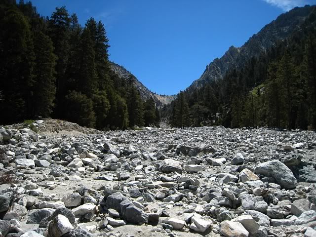
Going up Mill Creek was pretty uneventful. You better like rocks if you do this route because they're everywhere. There is a 20 ft waterfall but it can be bypassed by taking a trail marked by cairns on the right side of the canyon. As you near the headwall, Mill Creek Canyon closes in so you have no choice but to hike in the actual creek.

The hardest part is climbing the Mill Creek Jumpoff headwall. The only research I did before this hike was John Robinson's book and he doesn't say much about how you're suppose to climb this thing. There is no way to bypass it on either the left or the right. I decided that I'd just figure it out when I got there. Later when I got home I found this info from the Sierra Club HPS site:
The best route up the headwall is to ascend the gray-colored dirt up the center then, near the top, contour to the right on steep slopes to join the saddle. Avoid starting up the left side (in the tan dirt), as the ascent is not viable, becoming very steep and loose, and it is very difficult to traverse to the right from there. WARNING: the wall is concave in shape, so gets steeper with elevation. This is not apparent from below, so the tan dirt can seem to be superior. Do not fall into this trap!
You can probably guess what I did. I climbed up the tan dirt! From below it really does look like the best route. It's not bad until about half way up where there is no longer a field of large rocks to support your weight. It basically becomes a very steep slope of loose, soft, unstable soil.

Since the soil was so unstable, I duckwalked up to try to reduce the pressure on the soil and to prevent a slip-out. I also drove my trekking pole into the soil as a crude belay and to take some weight off the soil beneath my feet. Each step I took I would sink a little and then slide back 6 inches or so. I tried to plan my route so that I would reach a large boulder that looked stable every few feet. But almost nothing in that headwall is stable.

The whole thing was just too sketchy so when I was about 50 feet from the top I decided to traverse right about 30 feet to reach the saddle. This turned out to be a very bad idea!! Do not try to traverse an unstable, steep rocky slope! The right part of the tan dirt is even steeper and even more unstable. As I was going across, I used some of the rocks as hand holds. One big rock let loose and caused a huge rockfall down the headwall. Plumes of dust billowed up all around me. Crap, the soil beneath me could have let loose too. So I went back to where I was and proceeded to climb straight up. Eventually I made it to the top, which is covered in beach sand. Weird.

There is a faint use trail up to the peak from there. It's fairly steep with a couple of drop-offs down the lethal north face of Galena. One nice thing about this peak is there is no false summit. When you look up to see how far you have to go, that really is how far you have to go.

I was really dreading the descent down the headwall. It turned out okay as long as I took my time and was super careful. It helps to have experience with descending scree slopes, although this wasn't really scree. The rest of the descent was pretty miserable. Most of the rocks are very angular in shape and they're that annoying size where they're not big and heavy enough to not move when you step on them. So when you, it's like slipping on a banana peel.

****

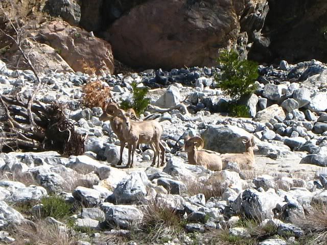
I saw these four bighorn sheep just a half mile in from the parking lot:
Image

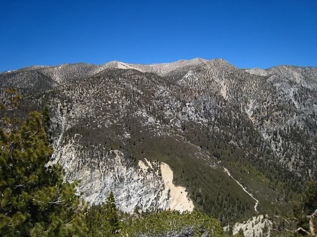
Mill Creek Jumpoff in the distance:
Image

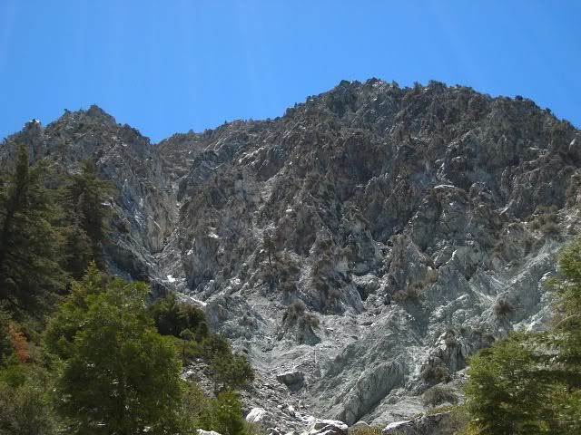
Extremely rugged north face of Galena Peak:
Image

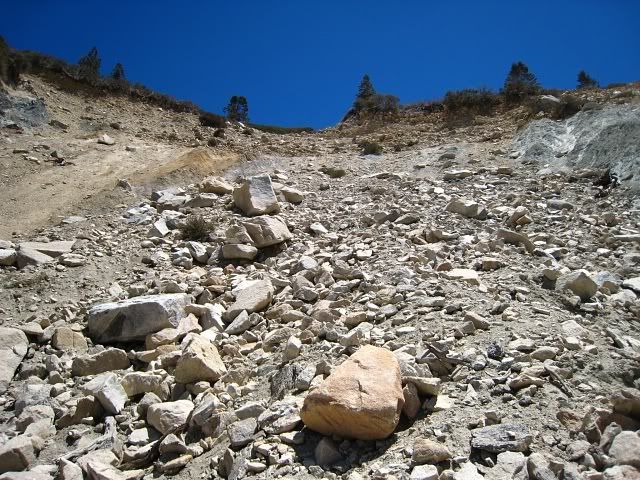
About halfway up the headwall. My final route was straight up the center towards the break in the brush at the top:
Image

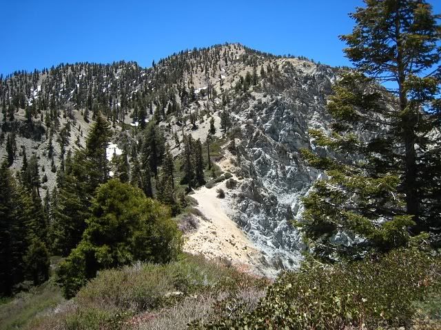
View from on top of the headwall looking towards Galena Peak:
Image

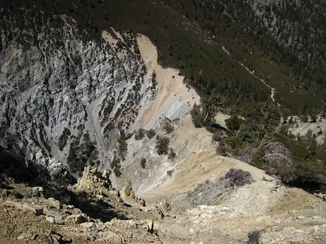
Looking back down at the Mill Creek Jumpoff. The brush behind the headwall is impenetrable. So you have to traverse the narrow edge along the top:
Image

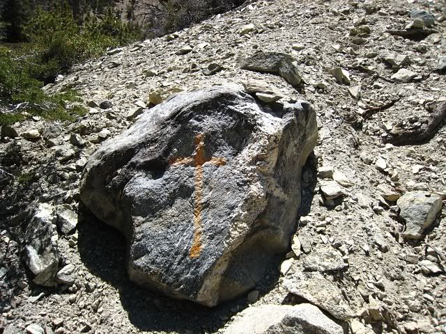
I saw three rocks with these orange crosses on the ridge up to Galena:
Image

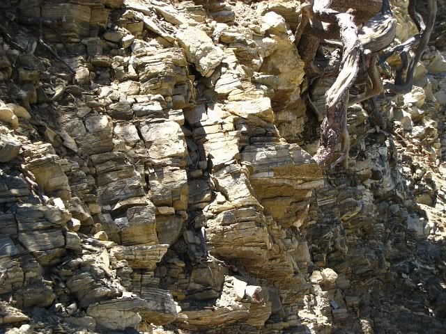
The rock here is as bad if not worst than the San Gabriels. Dangerous stuff.
Image

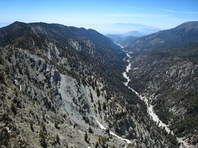
Looking west down Mill Creek Canyon and Mill Creek. Baldy and the San Gabriels in the distance:
Image

I did some recon of the south side of Gorgonio for people who want to hike Vivian Creek. Looks like no snow to me.
Image
FIGHT ON

Post by FIGHT ON »

Ever checked to see if you are related to Rick Kent?
User avatar
JMunaretto
Posts: 370
Joined: Thu Feb 07, 2008 11:03 am

Post by JMunaretto »

I like how you just disregarded the sierra club explanation to AVOID the tan dirt, lol.

Bighorn sheep! I want to see some. I guess there's a better chance to see them if you go alone and less noise?

Thanks for the update on Vivian Creek, looks like a go for this weekend. Oh btw, apparently there was almost no snow to Cucamonga. Damnit!
User avatar
Tim
Posts: 560
Joined: Tue Apr 08, 2008 8:55 pm

Post by Tim »

Nah, I'm nowhere near his level.

It probably isn't that bad once you've done it a few times. Mars Bonfire has been up there 18X (last register entry 11/07) . But thanks, Fight On, for keeping me safe. I kept thinking that I better not fall and go boom otherwise Fight On is going to be right and we can't have that. :lol:

Joseph, the weird thing about the Bighorns was they were just a half a mile up the creek from the Vivian Creek TH parking lot and that picnic area, which usually has a lot of people milling around. I also didn't know about the tan dirt thing until I got home. Just thought it was funny that I fell into the exact trap that they described, even down to the bit about trying to traverse right. Heard about Cucamonga too. Oh well, sometimes that's just how it goes. Good luck on VC this Saturday!
FIGHT ON

Post by FIGHT ON »

Tim wrote:fall and go boom
:cry: NOT A GOOD THING.

Mars Bonfire has been up there 18X (last register entry 11/07)
There is a register up there and he went up there (that way) 18 times?? EIGHTEEN TIMES? LIKE, ONE, TWO, THREE, FOUR, FIVE, SIX, SEVEN, EIGHT, NINE, TEN, ELEVEN, TWELVE, THIRTEEN, FOURTEEN, FIFTEEN, SIXTEEN, SEVENTEEN, EIGHTEEN TIMES? THATS NOT NORMAL IS IT? MAYBE HE IS RELATED.
User avatar
Taco
Posts: 6000
Joined: Thu Sep 27, 2007 4:35 pm

Post by Taco »

I've been to the summit of Iron Mountain 75 times. :lol: (True)

Galena Peak looks awesome. I've talked with a few folks who've done the north face. Looks like fun.
User avatar
Augie
Posts: 345
Joined: Fri Sep 28, 2007 2:17 pm

Post by Augie »

Tim,

I had a very similar experience to yours back in 2006. It was January and the headwall was a combination of dirt and ice. I to went way too far left going up the headwall because it looked like the best route. I then started to traverse to the right and realized right away it would only get you a fast trip to the bottom of headwall. Fortunately, I had crampons and managed to downclimb very gingerly to a level where I could traverse. Once I got to the ridge it was a beautiful snowclimb to the summit. One other thing about going up the canyon is that the left side as you face the headwall tends to have a lot rockfall so its best to stay away from that side as you travel up the creek.
User avatar
KathyW
Posts: 212
Joined: Thu Sep 27, 2007 9:00 pm

Post by KathyW »

Tim wrote: You can probably guess what I did. I climbed up the tan dirt! From below it really does look like the best route. It's not bad until about half way up where there is no longer a field of large rocks to support your weight. It basically becomes a very steep slope of loose, soft, unstable soil.
Tim: That's exactly what I did when I climbed Galena - I climbed the tan dirt because it looked like a good way to go - I sure was wrong - I was really glad when I made it to the top of the headwall safely. I came down in the grey dirt, which was fine. I kicked myself for not reading the description on the HPS site better.

It's a really pretty area back in there. I'm going to climb Little San Gorgonio pretty soon - I hear there's lots of fun too.

You were so lucky to see those sheep and you got a great picture of them - I've seen a number a bears in the SGW, but I've never been seen any of the sheep.

Kathy
User avatar
Tim
Posts: 560
Joined: Tue Apr 08, 2008 8:55 pm

Post by Tim »

Augie wrote:One other thing about going up the canyon is that the left side as you face the headwall tends to have a lot rockfall so its best to stay away from that side as you travel up the creek.
Good point, Augie. I forgot to mention that in the TR. I heard and saw one big rock fall from the north side of the canyon but no other ones that day. Still, I have to admit I wasn't as alert as I should have been. Definitely stay on the lookout for rock fall, especially further up the canyon where the north side goes nearly vertical.

It's interesting that you and Kathy have nearly identical stories as me of climbing that headwall. So you two definitely know what I'm talking about!

Kathy, I was really surprised to see those bighorns. I read that they are rarely seen in the SGW, so it was even weirder seeing them near the VC trail head. They almost looked like they were lost. Two of them were lying down while the other two were looking around like they were trying to figure out where to go. Little San Gorgonio Peak from Camp Creek looks like a fun climb too. Apparently you can also traverse the Yucaipa Ridge from Little San Gorgonio to Galena. I read some register entries on Galena of people who did that and one said no rope was needed but lots of Class 3. Our friend Rick Kent had an entry and wrote "What a wickedly diabolical route. I loved it."
Post Reply