
Non-SGM XC Routes


But, but... no brush = no fun. 
A lot of the peak bagging routes in the San Gorgonio Wilderness are pretty brush free.
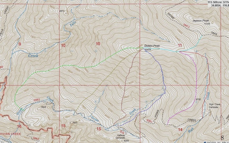
Dobbs Peak from Vivian Creek camp is a popular XC route (shown in green on the map below).
I haven't done that route, but it's pretty popular.
Grinnell Ridge to/from Grinnell Mountain is pretty brush free. I did that route last year. Very nice. Feels remote.
Ten Thousand Foot Ridge is pretty brush free. You can go from Fish Creek Saddle or Lodgepole Saddle (I've done both). You can go down the ridge as far as you like.
Of course Bighorn Mountain and Dragon's Head Peak involve some fun XC. Not much brush there although there are some shrub like pine trees you have to go through. I was able to find a path.
HJ
A lot of the peak bagging routes in the San Gorgonio Wilderness are pretty brush free.
Dobbs Peak from Vivian Creek camp is a popular XC route (shown in green on the map below).
I haven't done that route, but it's pretty popular.
Grinnell Ridge to/from Grinnell Mountain is pretty brush free. I did that route last year. Very nice. Feels remote.
Ten Thousand Foot Ridge is pretty brush free. You can go from Fish Creek Saddle or Lodgepole Saddle (I've done both). You can go down the ridge as far as you like.
Of course Bighorn Mountain and Dragon's Head Peak involve some fun XC. Not much brush there although there are some shrub like pine trees you have to go through. I was able to find a path.
HJ
The Santa Ana's Have way too much brush for any real XC routes, but there are a few canyons with waterfalls that have use trails and some fun bouldering and rock hopping. all three of these are best done in spring following a few days of rain, if you attempt in fall or late summer the creeks will most likely be dry.
the legendary Blackstar canyon falls - Rumored ghosts, crazies, and a protective land owner stories mostly mumbo jumbo . 6-7 miles total 5 on a dirt road 1.5 miles of really fun canyon adventure, lots of interesting canyon features. the closer you get to the falls the larger the boulders get even a few car sized ones. There is some poison oak but its all avoidable. http://www.flickr.com/photos/98779591@N ... 053093022/
Lesser known Harding canyon Falls- only 8 miles round trip to this remote 40 ft falls, but it takes 3-4 hours to get to the falls. Mostly boulder hopping along the watercourse not much brush. in times of higher flows you are very likely to get wet. some of the best swimming holes in the Santa Ana's are found here. http://www.flickr.com/photos/98779591@N ... 923081375/
Hot spring canyon- 3-4 miles round trip depending on how far into the canyon you go. some brush early on depending on the season and if anyone has recently cleared the "trail" follow the dry creek after two tributaries join the creek has water. You pass a 25ft falls with a decent pool in spring this is where the canyon begins to get a little wild. hopping rocks and a few smaller cascades until you reach the top of a 30ft falls with he deepest pool in the Santa Ana's its possible to jump in from the top(sometimes). use the bypass trail to get around and access the narrows section with 2 more interesting falls and plenty of frogs. any further usually requires ropes, but there is an interesting bypass trail that could make it to tanrivendi falls 160ft hidden falls but I'm not sure if its passable. http://www.flickr.com/photos/98779591@N ... 045459789/
Those are some great suggestions. Thank you. I've only done established trails/fire roads in those areas and need to go exploring. Harding Canyon looks like a real winner. And I've been meaning to hit Dobbs Peak but wasn't sure which way to go.
Local Naturalist group's pictures of Harding canyon here http://www.flickr.com/photos/naturalist ... 960376450/. The canyon is at its best after a few good days of rain, and can be dry in the summer if its a dry year.

You can climb Modjeska from the Maple Springs Visitor Center parking lot.
There is a use trail on the right about 200 ft. past the gate that heads into a dry creek. Head up the creek about 1/4 mile to a continuation on the left. From there, fire breaks and use trails over many bumps. I clocked it at 8.6 miles, 3875' gain. Steep at the beginning. First two miles >2000'.
The nice thing about this route is that you can do it in winter when the gate is often closed to protect the dirt roads.

Here's an interactive map of the San Gorgonio Wilderness. I've sketched in a lot of winter routes (in blue) and XC or long abandoned trails (in gold).
HJ
You're welcome.
I switched it up a bit since I started:
XC routes continue to be gold.
Old trails now are shown in yellow.
There's a legend available at Interactive SGW Map. The legend explains the somewhat cryptic numbers by the various symbols and has various cross references for trail camps and trailheads. Not that guys as fast as you ever overnight in the wilderness.
HJ