
EAST Horsethief Trail (Santa Ana Mtns)
-
atomicoyote

- Posts: 173
- Joined: Fri Dec 24, 2010 2:16 pm
Does anyone who has frequented the trails along the Main Divide Road know if this still exists at the lower portion down near Lake Elsinore?. (I'm not talking about the popular WEST Horsethief trail which comes out of Trabuco Canyon). It's mentioned in the old Ken Croker guidebook, but not in Jerry Schad's book. 1980s-1990s development in the northern area of the Elsinore basin may have wiped out the starting point (it was tricky to find, requiring navigating a series of fire roads). IF someone knows where it starts, post up! If not, I might try descending it from where it intersects the Main Divide Road sometime this winter to see if its still viable.
http://www.fs.usda.gov/recarea/clevelan ... 4&actid=50
FS website says there is no east side trail head, but google earth shows a trail going all the way from the main divide down to the temescal valley.
Couple of bikers rode the trail with go-pros, doesn't show if they exited at
the bottom or rode back up.
FS website says there is no east side trail head, but google earth shows a trail going all the way from the main divide down to the temescal valley.
Couple of bikers rode the trail with go-pros, doesn't show if they exited at
the bottom or rode back up.
-
atomicoyote
- Posts: 173
- Joined: Fri Dec 24, 2010 2:16 pm
Thanks for the video. I tried tracing it on Google Earth, too, and it went down that 'feral' fire road shown in the Youtube video. I remember it being a 4 mile long trail (the MTBr's route was probably longer) that intersected the fire road not too far from the Main Divide Road intersection after a 2600 ft elevation gain. I may have to dig a little deeper and see if I can find a starting point. Cheers

I have a 1995 edition of the Jerry Schad book for Orange County. He describes a hike for East Horsethief Trail with the following directions to the TH:
Please take it with a big grain of salt since it is 19 years old and I would bet the landscape has changed quite a bit. Maybe it will be enough for you to find the old trail, though. He has the trail marked as 9 miles round trip to Main Divide and 2900' of gain.Exit I-15 at Lake Street, continue south (Lake Street becomes Robb Road). at Mountain Street, 2.5 miles from I-15, turn west and go 0.5 miles through a new subdivision (plenty of curbside parking) to its west edge. Leave your car here and walk northwest on a dirt road leading from the edge of the subdivision (elevation 1565' on the topo map) toward the base of the hills. Continue across a gravel-surfaced truck road. After 0.4 miles of walking you'll spot a large eucalyptus tree on the slope to the left. Here, the East Horsethief Trail strikes off to the left and curves up the slope. It then trends west along the top of the ridgeline between Rice and Horsethief canyons.
-
atomicoyote
- Posts: 173
- Joined: Fri Dec 24, 2010 2:16 pm
tekewin wrote: ↑I have a 1995 edition of the Jerry Schad book for Orange County. He describes a hike for East Horsethief Trail with the following directions to the TH:
Please take it with a big grain of salt since it is 19 years old and I would bet the landscape has changed quite a bit. Maybe it will be enough for you to find the old trail, though. He has the trail marked as 9 miles round trip to Main Divide and 2900' of gain.Exit I-15 at Lake Street, continue south (Lake Street becomes Robb Road). at Mountain Street, 2.5 miles from I-15, turn west and go 0.5 miles through a new subdivision (plenty of curbside parking) to its west edge. Leave your car here and walk northwest on a dirt road leading from the edge of the subdivision (elevation 1565' on the topo map) toward the base of the hills. Continue across a gravel-surfaced truck road. After 0.4 miles of walking you'll spot a large eucalyptus tree on the slope to the left. Here, the East Horsethief Trail strikes off to the left and curves up the slope. It then trends west along the top of the ridgeline between Rice and Horsethief canyons.
Thanks. With the images from the video Scottawr posted, I did a little more research, including carefully following the path on Google maps, and I think I found where it starts. I'll Probably go check out the starting point in the next few weeks.
HOWEVER . . .
Just before Christmas I came down with a case of blood clots in my leg ('Deep Vein Thrombosis,' if you want to google the details) and that's going to keep me off the trails, bicycles, and any epic outdoor adventures for at least 6 months (per my doctor's estimate). F'n sucks big time . . .
A last minute decision led to exploration of this trail on Sunday, ending on Horsethief Peak.
To get to the trail from Orange County, take highway 74 over the Santa Ana Mountains into Lake Elsinore and follow it as it turns north. Turn left on Grand Avenue, then left again on Mountain Street. At the end of Mountain Steet, there is a dirt road that forks three directions. Take the middle road, Rice Canyon and go straight past the curve. You soon reach a gate on the left that Google Maps thinks is the trail, but it's not. The USGS shows the trail starting about a quarter mile further up the road on the left. Trust the USGS on this one. You can park at the first gate or at a wide section of the road around a bend and walk up the road a short distance to the trail. There was no space for parking at the trailhead.
Not knowing any better, I parked at the first gate and went through it to follow the dirt road. I immediately found myself in the middle of a hundred commercial bee hives from the Happie Bee Co., Menifee, CA. Bees were flying back and forth between the hives that lined both sides of the road. I covered my head and walked briskly past them. A few bees flew into me unintentionally without bothering to sting me. I followed use trails past some camp sites down into the creek looking for a connector trail to East Horsethief. Maybe there was a connector trail somewhere but I didn't find it, instead suffering a short thrash up the creek until I hit the main trail.
The trail climbed in manageable chunks with level spots along the ridge to catch your breath. It was in much better shape than I expected and easy to follow. Only a few spots could have used some trimming, although much of it is rutted from mountain bikes. I went through a stand of pines just before reaching Main Divide Road. From there, you can head directly up the brushy north firebreak of Horsethief Peak. I turned left and headed to the clear south firebreak. Clouds rolled over the summit of Horsethief just as I arrived. I didn't stay long and it was much faster on the way down. The views were great all along the trail. Here are a few photos:
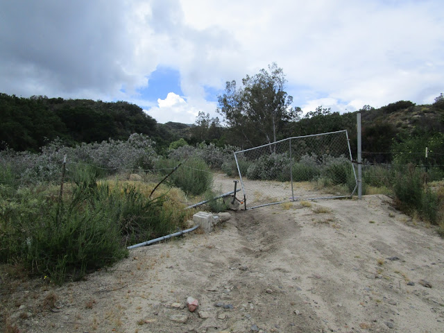
Wrong trailhead, leads to bees and bushwhacking
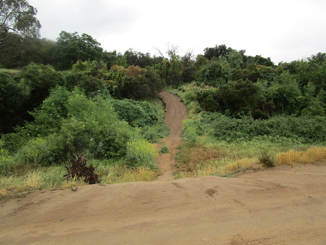
The right trailhead, parking available along road before reaching the trail
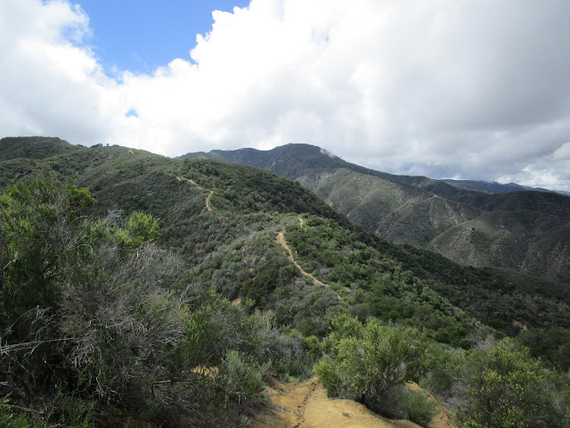
East Horsethief trail and Trabucco Peak
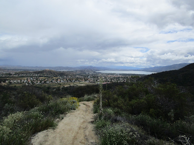
Lake Elsinore
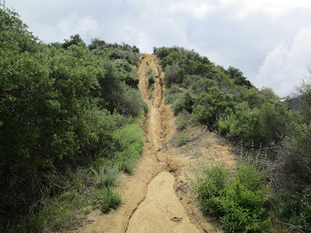
Rutted
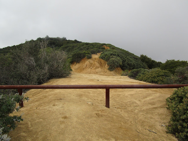
Intersection with main divide, Horsethief Peak dead ahead
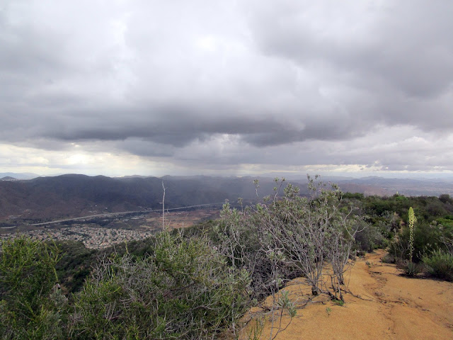
Stormy on the way down, but I only got light rain
To get to the trail from Orange County, take highway 74 over the Santa Ana Mountains into Lake Elsinore and follow it as it turns north. Turn left on Grand Avenue, then left again on Mountain Street. At the end of Mountain Steet, there is a dirt road that forks three directions. Take the middle road, Rice Canyon and go straight past the curve. You soon reach a gate on the left that Google Maps thinks is the trail, but it's not. The USGS shows the trail starting about a quarter mile further up the road on the left. Trust the USGS on this one. You can park at the first gate or at a wide section of the road around a bend and walk up the road a short distance to the trail. There was no space for parking at the trailhead.
Not knowing any better, I parked at the first gate and went through it to follow the dirt road. I immediately found myself in the middle of a hundred commercial bee hives from the Happie Bee Co., Menifee, CA. Bees were flying back and forth between the hives that lined both sides of the road. I covered my head and walked briskly past them. A few bees flew into me unintentionally without bothering to sting me. I followed use trails past some camp sites down into the creek looking for a connector trail to East Horsethief. Maybe there was a connector trail somewhere but I didn't find it, instead suffering a short thrash up the creek until I hit the main trail.
The trail climbed in manageable chunks with level spots along the ridge to catch your breath. It was in much better shape than I expected and easy to follow. Only a few spots could have used some trimming, although much of it is rutted from mountain bikes. I went through a stand of pines just before reaching Main Divide Road. From there, you can head directly up the brushy north firebreak of Horsethief Peak. I turned left and headed to the clear south firebreak. Clouds rolled over the summit of Horsethief just as I arrived. I didn't stay long and it was much faster on the way down. The views were great all along the trail. Here are a few photos:
Wrong trailhead, leads to bees and bushwhacking
The right trailhead, parking available along road before reaching the trail
East Horsethief trail and Trabucco Peak
Lake Elsinore
Rutted
Intersection with main divide, Horsethief Peak dead ahead
Stormy on the way down, but I only got light rain