Photo by Jose
Times will be measured in 24H/Military
Abbreviations:
LP: Lone Pine
HMR: Horseshoe Meadows Road
WPR: Whitney Portal Road
PJAMM Climb List: https://pjammcycling.com/zone/6.California
I am using this and several other sources for what dictates the 'hardest' or whatever-est climbs in CA. Ratings are relative, and one can do this or that to make it easier or harder. It's a good guide with tons of info and I found it very helpful.
I had a few big road climbs on my radar for a while, namely Horseshoe Meadows Road, with the downhill being something I've dreamt of for years. I cooked my brakes on my '90 240SX downhill after a trip to Cottonwood Lakes for an attempt on Langley in early winter conditions. Since then I've dreamt of running it downhill, by car or bike, with a big focus being on brakes and corner traction.
Anywho, before going off on an equipment rant (which will happen later), I'll outline my trip in numbers and simple terms before going into detail.
Day 1: Ride to Lone Pine
Day 2: Attack Onion Valley (hardest road climb in CA)
Day 3: Horseshoe Meadows Road (number 1 objective)
Day 4: Whitney Portal and return home
-=Day 1: West Covina to Lone Pine=-
https://pjammcycling.com/climb/73.Hwy%2 ... 2520Saddle
Day 1 started for me on Tuesday the 16th around 1800 hours. I met up with Kris, a fellow Dune Ape, at the base of Route 39 and we rode up to East Fork Road together. He headed up GMR for a night descent of Lower Monroe on his hardtail, and I continued up 39. Got water at the roadside spring, filling all my bottles for nearly a gallon of water. I normally hike my bike over Windy Gap to the 2, but this time I rode the closed section of 39, since it was late at night and nobody would be up there. I saw no wildlife for once, as I typically see a bobcat up there. It's a great section to ride, as you really feel you're in the big mountains away from the city. I had a full moon all week, and lunar illumination lit up Bear Creek and I was able to somewhat see what the damage was from the Bobcat fire.
I had some snacks at Islip Saddle, stretched, then continued up to Dawson Saddle, #8 hardest climb in CA, a good start to the trip. There's a fun, chill descent to Vincent Gap, a short climb to Blue Ridge, then a long fast descent through Wrightwood to the 138. Left on 138, right on Sheep Creek, then I took that to its terminus at El Mirage Road. I have ridden part of El Mirage Road before further west, and wanted to see what this eastern section was like. I am always looking for the ideal way to go places by bike, which typically means having low vehicular traffic and/or a decent shoulder. This was not the case this time, and there was some significant commuter traffic from 0400 onward. Took El Mirage east to Koala, south to Chamberlaine to the 395, where I turned north and rode straight to Lone Pine.
I got to watch the sun rise over the mountains to the east, and the sky turned colors I wish I could capture in a photo. The slight tailwind I had died off and things remained calm the rest of the way north. I stopped for food at Burger King in Kramer Junction as always, and picked up some food and drink. Food prices continue to climb, making bike touring more expensive, especially if you're going light and aren't bringing a stove, relying on civilization to provide food. I began the climb north to Randsburg. Nothing notable happened along the way, it's all the same 395 you're familiar with. At some point the sun set, I got two sandwiches at Subway in Pearsonville, and took another break at Coso Junction, where a nice gentleman named David and I talked for a while and had some chicken. I continued north through Olancha, watched the bottling plant produce water bottle packs as I rode past, and ended in Lone Pine. I had considered riding the extra 16mi to Independence, the start of my first climb, but decided against it. There's a taco truck in Lone Pine, Castro's Tacos I believe which had Chicharron, my favorite meat for Mexican food, and I got a burrito with that. It was outstanding! I also ate a mulita with cabeza, and my farts the next day would prove heinous. Highly recommend this truck. I think they close at 2300, and I got there at 2230, just in time. The only place open, which for once was the best case scenario. Thanks guys. I went to sleep behind the bathroom in the park.
*Totals for the day*
242mi
14,450ft gain
7,895ft max elevation
22h 21m moving time
28h 49m total time
40mph max speed
10.8mph average speed
-=Day 2: Onion Valley Road=-
https://pjammcycling.com/climb/32.Onion ... ad-Cycling
Onion Valley is listed as the hardest climb in CA, so I figured it would be smartest to tackle it first. It doesn't go as high as Horseshoe Meadows, nor is it as long, but it is steeper, and for quite some time.
I began my day by cleaning up my bivy site at the bathroom when a maintenance truck pulled up. I figured I'd get talked to, but they just changed the trash can liners and moved on. Maybe they didn't see me, maybe they didn't mind. I rode to the McDonalds and got some breakfast and a nice hot coffee to warm up. Rode north and put on Like a Pimp by David Banner, a true classic, followed by Amon Amarth and who knows what else. Made it to Independence, utilized their latrine, and started up the road. It feels pretty steep right from the beginning, and despite the chill weather the sun was beating down on me, so I removed my layers. I slowly climbed up the long straight start heading into the mountains.
There's a stream that roughly parallels the entire ride, so water was no problem. This is probably seasonal, and there was some light snow covering the peaks feeding the stream. I could see this being dry in the summer. I filtered a liter of water before going further up. The route passes a couple campgrounds and eventually you get into some hairpins and turns which are quite steep. I would dismount and walk for some sections, and my speed was the same at about 3mph either way. I was running a 53/39 crank and an 11/46 cassette on this trip. I normally have a 46/30 crank which gives me much lower gearing, but that was worn out and unrideable. My lowest gear with the current setup is sufficient even with a total weight of about 65lbs.
Anywho, I walked and crawled my way further up the mountain with awesome views all around. Eventually I made it to the top at around 9,200 where I put more air in my tires, did drivetrain maintenance, and downed my other footlong from Subway the day prior. I was gonna put a sticker somewhere up there but spotted one on a bear box while stretching! Hehe! Hmmm, who did that?
Fueled up with old sandwich and tires topped up, I headed down. What a dope descent! The cracks/joints every 30ft or so on the road weren't a big deal with my wide tires (650b x 47mm), I just lean back a tiny bit and float over em. I had heard there are some powerful crosswinds on the way down, and saw Safa Brian get pushed around on his fast descent, so I took a line closer to the mountain away from the edge and gave myself lots of recovery room. The winds weren't that bad when I did this, but they did push me around a bit. I suggest this tactic. There wasn't much dirt on the road, so I was able to corner confidently. The hairpins are fun and don't hold any surprises, as you can see the whole thing as you approach and enter. The steepness meant I initiated braking earlier, gently feeding in braking input before getting just below threshold braking upon entry, and applying sufficient power on exit. My weight balance was slightly towards the rear over the wheel as it is that steep! Very fun to have to apply more technique to descend a paved road. Things straighten out and you have a very long steep series of straights to power through, and a cattleguard to pass over. I hit 46mph on this and could certainly move faster if I was more aerodynamic/didn't bike tour here kinda deal. My lower back started to cramp up from holding a tucked aero position for so long so I eventually sat up a bit on the hoods to relax while flying down.
It took me about 4 and a half hours to go up and only about 20min to get back down! An outstanding route that I highly suggest to anyone in the area.
Back in Independence, I considered going to the ice cream place but decided against it, as lactose intolerance would mean discomfort in the long haul. The pics on Google Maps of that business got me craving it, so maybe next time when I'm not on a saddle all day.
I rode south, checked out Manzanar, and went to Lone Pine for dinner. When I was in the market to pickup up some food, two guys asked if I was bikepacking, to which I responded "sort of", and we struck up a conversation. They were here to film speedy descents in the area, similar to what I'm doing, and so we decided to camp together. Part of the magic of bike touring is this sort of thing, stuff you can't plan. I can be a bit standoffish sometimes when I'm doing these trips, sometimes people ask the same questions and I try to stay in the shadows, but it's good to say yes to things at times and a lot can come of it. We agreed to camp together at Alabama Hills, where I had planned to go anyway.
Pablo and Jose drove from Fresno, and Jose and I were gonna ride up Horseshoe Meadows while Pablo drove up Whitney Portal to scout it out for a filmed speed run. I bought some beer and smokes and we had a campfire before they slept in their cars and I slept in a little rock alcove out of the wind. Despite three new patches on my sleeping pad, it still went flat in the night, but my new REI Magma 30 quilt proved to be comfortable despite the wind and chilly temps. Time for a new sleeping pad I guess.
*Totals for the second day*
60.5mi
5,746ft gain
9,187ft max elevation
7h 44m moving time
10h 17m total time
46.6mph max speed
7.8mph average speed
-=Day 3: Horseshoe Meadows Road=-
https://pjammcycling.com/climb/34.Cycli ... Meadows-Rd
In the morning I cleaned up and hid my bike in some rocks, riding in the car with the boys to breakfast at the Alabama Hills Café, where I got a breakfast burrito and a coffee. A delightful breakfast. Afterwards, we headed back up and prepared for HMR, with me taking anything I didn't need for that ride and putting it in one of the cars, saving me a bit of weight. Jose and I rode out from camp up Whitney Portal Road, making a left on HMR. There is a super long straightaway that climbs up to the first hairpin on this incredible route.
Every account I've read has roadies climbing this in intense heat in the summer, and I thought that sounded awful so I planned to avoid this area during such conditions. It was wonderful weather as we climbed and eventually hit the gate near a small community. A car had passed us earlier and told us the road was closed. I suppose he isn't a cyclist. This was great news as it meant a very low chance of other vehicles on this road! We went around the gate and continued up when Pablo called and said he completed scouting WPR and was considering joining us. We told him he better come out, and he headed our way. We chilled on the roadside while he kitted up and caught up with us.
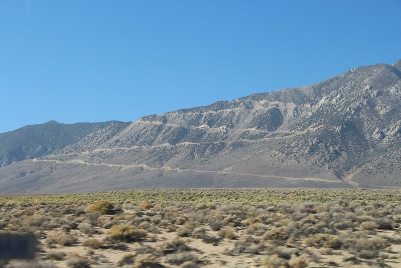
The ride up was not as steep as Onion Valley, thankfully, and much more dramatic. The road looks amazing from the valley, a series of huge hairpins that look as if they were drawn by the god of cycling and motorsport. You have 5 primary switchbacks with a 6th further up just out of view, and those 5 primaries have incredible straightaways connecting them. The upper straights have minor turns on them but are easy to straighten at cycling speed. After the 6th hairpin, you have a straight that hits a dogleg, with the end at 10,000ft at the trailhead for Cottonwood Lakes region.
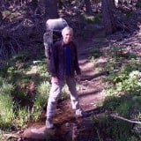
The climb was chill, with shade provided by the mountain and really just incredible views as you climb higher above the Owens Valley. Looking up the side of the mountain you can occasionally see the next straightaway so high above you, you feel as if you're in some sort of fantasy world, some comical mountain road drawn by a child to absurd dimensions. The road surface was mostly clean with some sand lower down in places and minimal rockfall, some some cracks but nothing of note. Pablo and Jose didn't have cold weather kit and were gonna be quite chilly on the descent while I was bundled up in my layers. Pablo decided to stop at the top of the real downhill around 9,600ft and wait for us to hit the top. Jose and I rode on to the trailhead, took a photo, and I layered up for the descent. There was a little snow here and there, but the road itself was completely clear and dry. We descended 2 miles to the little climb up to Pablo, and found him excited but freezing waiting for us in the sunshine, out of the wind. Upon our arrival, he set up his GoPro on his helmet, and set me up with a microphone. We filmed the descent, so I'm excited to show that footage when he has finished processing it. We had trouble getting the little fluffy microphone cover thing on the mic, as I had no experience with such things and Pablo's fingers were frozen. Poor guy had to jump up and down to warm up! Once everything was set up, we turned towards the valley and began the descent. I was keeping in mind that he's the camera operator and I can't be too far from him, and we each had our own advantages for speed with him being more aerodynamic but me with fatter tires and functioning hands (warm gloves!). I applied somewhat significant power and began the run.
Descents are one of my favorite things in life. I probably write more in detail about them than anything else. I had thought of this specific descent for years, and though I had those thoughts they didn't cloud my mind when I began my run, I just moved as I must. I found it easy to take a fast line on descent, using both lanes as I was both confident car traffic would be low to nonexistent and the line of sight on most of the descent is outstanding, which means I can see the road far, far ahead and alter my line easily, even at speed. There would be zero traffic the entire time. This descent takes you from 9,600ft to 3,700ft, that's 5,900ft of descent in one shot, which is absurdly awesome.
The descent from the 9,600ft point has some easy turns before Walt's Point, where the views open up and you're fully over the Owen's Valley. More easy turns ahead to a long straight pointing right at the valley, with a very sharp hairpin that abruptly pulls you out of the fast straight character of the previous section. A wide line to the left with a standard apex and modest power exiting would be ideal, careful of dirt in the corner, a short straight leads to the next hairpin which is nearly the same, but with a later apex and wide exit with more power upon exit for the easy right-left ahead, early braking and a left turn onto the top straight as seen from the valley. Lost of easy kinks on the top few straights which link up easily into a straight at cycling speed. A fast line is easy to take from here on down. The next hairpin comes up with insane views, and with the sun over the mountains the Owen's Valley is bathed in changing light as we race in the shade down a road from my dreams. The next straight composed of similar kinks made by the same ridges running up the mountains presents you with a right hander which feeds you into the next hairpin, allowing you to brake incrementally and slow down just right. This hairpin is a bit wide and gave me enough time to think that I should be applying more power mid-corner. I'm a bit conservative on roads I haven't run before, giving myself a recovery line and plenty of room. The hairpin spits you out into a series of corners which bring you back over the valley and in line with the 'straight', with lots of sweepers and one kink in between to keep you thinking just enough. A gentle right sweeper taken at high speed puts you onto a very fast straight directly into the next hairpin, with my mind given ample time to think of my braking input as I enter the hairpin. Wide left, gentle early cautious braking input, aware I cannot afford to come in too hot or you could fly off the side and most likely die or get truly jacked up, an easy line through the corner, wide exit and a very long fast straight. The last hairpin is ahead and the ridges have widened on the mountainside this far down, so the corners on this straight are fast sweepers, barely there, with you taking a very fast double lane line. A gentle right turn feeds you into the final hairpin, the same geometry as the previous one, and you power out onto the next straight where you look directly at the way down to Alabama Hills. A huge grin on my face as I just completed a dream descent, one I hope to repeat many times until my days are up. The gate comes up shortly thereafter, and Pablo and I stop at his car nearby and wait for Jose. Jose shows up, we put camera kit away, and Jose and I still have the long straight back to Alabama Hills to take. This one is much more chill and less steep, but still relatively fast. It flattens out near the end and I can definitely tell I was pedaling hard down the road as I chill out and slow down. We meet up back at the campsite, pack up a bit, and go meet my buddy Jared for Pizza. I bought an XL pizza which cost a fortune and just about put me to sleep. We hung out and talked before heading back to camp and sleeping.
*Totals for the day*
41.26mi
6,331ft gain
9,955ft max elevation
4h 56m moving time
6h 37m total time
47mph max speed
8.3mph average speed
-=Day 4: Whitney Portal and Heading Home=-
https://pjammcycling.com/climb/56.Cycli ... ney-Portal
We woke up at a relaxed pace today. It was windy and Pablo was concerned about the strong crosswind potential descending Whitney Portal, which he said would be a very fast descent (it is fast!). He and Jose decided to go do some scouting and I left camp to ride up WPR around 1100, a 9 mile ride to the top. It's a long straight of some steepness up to the first turn, a right hander that takes you up to the first hairpin, the only one visible from the valley. The road had a little bit of sand here and there, but not much, and traffic was pretty low. The views of Lone Pine Peak are awesome, as it rises up enormous in front of you, gradually revealing more of its ridges as you get closer. I've climbed the North Ridge before and was looking at how it would be to climb the entire north ridge instead, which would be massive but now seems quite doable. The recent fire had burned the lower section of the ridge.
The road turns right and you face Whitney and the portal region opens up around you. This continues up in a straightaway with dope walls around you, especially the one to the left which looks like a mega-Tahquitz, trees growing in incredible places. You have two hairpins followed by a short straight to the trailhead at the top. I utilized the latrine and rode to the scale where people weigh their packs. I finally know how much my bike weighs! With one full bottle of water, it was 57lbs or so. A bit over 60 with all bottles filled, then.
The descent was beautiful, not as dynamic as the others but if you're a rock climber or alpinist, this one has the most thought-provoking views. So much climbing here, a lot of history, endless potential. To have a cabin here and go solo an incredible high quality route for lunch... anywho, I came into the first hairpin a bit too hot and went into the other lane. Fortunately no cars were heading up so I didn't look too stupid, and I took more care on the next hairpin, put some power down, and stopped partway to take a photo. A wide left hander takes you onto the top straight visible from the valley, feeding you into the big wide hairpin with an easy line to take at speed single-laning, onto the next straight with a kink into the left hander where you go down into the valley at very high speed. I hit 52mph on this section, the highest speed of the trip. Pablo bet I would hit 50 but I figured I'd do 46. He was right. If I were to try to hit a personal max speed anywhere in CA, this straight is it. It continues all the way down into Lone Pine, a truly awesome and easy descent with only a couple turns on the way. Being aerodynamic and having huge gears would be best here. 53 up front with 11t in back spins out so you'd need some huge track crankset to get enough power down. People just get as aero as possible and supertuck to get the highest speed. Pablo and Jose just happened to be at a corner ahead and I yelled, stopping to chat with em. They asked if it was windy, and I told em I experienced very little wind, with the worst being where we camped. I wanted Pablo to do the descent, as they were already here and conditions were ideal. They decided to do it, and I gave em a big hug and headed to Lone Pine. I bought some food and water, ate McDonalds, and began my long ride home.
Pablo called me when I was below HMR looking up from the 395 and told me he hit 60 on the descent. Very cool! I'm glad they went for it. It's important to give things a shot cause granted the mountain may always be there, but you won't, and life is complicated. It can take a lot of things to get back to such a place, so if you're there, just give it a shot. You might not have another.
I bid them goodbye again, and continued south. The sun set and I rolled into the visitor center to utilize the latrine again before continuing south once more. A break at Coso Junction rest stop for some snacks and stretching. A cute orange stray cat was hanging out and a lady gave him some food. I dropped some Frito crumbs and he checked em out while I filled up bottles and gave him some space. I hope he does alright, as it's getting cold. Maybe he's got a human, a trucker or someone who let him out to wander.
I ate at Subway and talked with the workers in Pearsonville at dark o clock, 2100 or whatever. The subway closes at 2100 so I suppose I got there a little before. It got quite chilly at times and I was gifted a bit of a tailwind, which helped me out quite a bit on the long climb up past the Ridgecrest area towards Randsburg and Johannesburg. It's a considerable downhill from Jburg to Kramer Junction, so I stopped at the post office to refill my main bottle with the ones strapped on my downtube, snack, and stretch. Put my layers on, and took the descent at a chill pace, stretching often. This is a lengthy descent, and I got to Kramer Junction in the early morning, where the market was open so I got some fruit juice, muscle milk, and some snacks. Pounded the milk, and sipped the juice for a few hours, which helped. A long but easy climb to Kramer Hills leads to some rollers towards Adelanto. I've done this section a handful of times and it's easy but not something I really look forward to. I stopped at the Taco Bell in Adelanto for various unimportant reasons and waited for them to open at 0700 or so. I accidentally ordered too many small burritos, which turned out to be a good thing, as I easily ate em all. This gave me much more energy as I was moving at a snail's pace previously, and I began another long easy slow climb up to Cajon Pass. The 395 hits Joshua Road at the Pilot/Wendy's near the end of 395 to the 15, and I took Joshua over to Mariposa. Take Mariposa until it turns to dirt and snakes down to 3n45. This then takes you to the 138, a fun downhill, and the McDonalds. Under the 15 on the PCT route through a wash, then up over the train tracks onto old route 66. The winds were mega powerful here and I rocketed down 66 to Glen Helen. The winds would help me when heading south and nearly knock me over when going west until I got far enough away from the mountains in Rancho on the Pacific Electric Trail. Surface streets took me home, and I had to walk on part of the final half mile home because my knees hurt so much.
*Totals for the day*
246.5mi
10,762ft gain
8,379ft max elevation
20h 17m moving time
27h 31m total time
52mph max speed
12.1mph average speed (not bad!)
*Closing Thoughts*
I had HMR on my radar for years. I'd come up with various trip ideas involving riding it among the other climbs on a longer tour coming from far away places, or going out with friends in a truck or van to do it cragging-style, and so on. Work has been slow lately and I haven't had any hours in a month, so I thought fuck it, let's just ride out there and do it. I packed up and had a false start where I had nobody to go with me on the first part, so I gave up one day and slept in, feeling depressed about everything. I asked Kris to ride with me up the 39 and so that gave me a reason to get out. Often times the hardest part of any bike tour is just leaving. I've failed to leave on so many trips. It can be disheartening. When you have a buddy willing to take even the shortest first few steps, when you have to meet them somewhere at a set time, that can be the most important spark to light the fire and get you out on something of great size.
I broke up with my girlfriend in July and it has been very hard for me. I find it hard to keep myself moving when it gets dark out and all you see is a bubble of light from your headlight. Sometimes I lack the discipline to stay positive and keep moving forward. It is important to learn everything you can from breakups and all situations and not just beat yourself up or go into a negative space, something much easier said than done. I underestimated this when I left on a bike tour in October that I haven't written about yet. Setting off on this journey to the Owen's Valley, I told myself I would not entertain negativity. You encounter 'negative' situations, but you learn from them and move on. The negativity pulls you down, weighs you down, takes up a lot of space, and does you no good. I set my mind to positive thoughts only and stuck with it through the trip. I was able to prove to myself that I can do my long challenging rides and be in control of my mind again. These things can seem overwhelming, impossible even, but they're just right there. They may be just a millimeter out of reach until you apply that self discipline you have, you just have to apply it and it will be firmly in your grasp. The impossible task ahead of you has just been made very possible, and it is yours.
I had thoughts on my trip, but they didn't turn dark or overwhelming. I thought through things, of the past, felt emotions, but moved through them as if on a cloud, smoothly and gently without anger, without dwelling. Only positive caring for those involved, love, and forward movement. Thank you, everyone.
Total numbers:
593.7 Miles
38,145ft Gain
I had to manually enter in 3.2mi with 860ft of gain for my ride from LP to Alabama Hills after Onion Valley, as I didn't think there would be reception in AH.
*Bike Stuff*
What to say about bike stuff? Gear choices, things I liked, things I'd do differently... endless. So before this trip my big ring on my GRX crankset was so worn out that I couldn't apply any power without the chain skipping off. The 46/30 GRX crankset gave me really low climbing gears, which is great for what I do, but not a fast enough top gear for descending at speed, which I love. I got my 53/39 Shimano 105 crankset back from load to Kris, gave him an Oval Components set in trade for his upcoming build, and hoped the lowest gearing of 39-46 would be enough for a loaded bike up the hardest climbs in the state. Turns out it was enough, and the top gear was great for the speed I crave and need to be a healthy strong ape boy. I suffered no drivetrain issues on the ride.
Let's see, what else? Well, my saddle sagged a bit so I raised the post a tiny bit, which helped, but I need to stretch the saddle a little I have some pretty heinous sores from it but not the worst and not really an issue. Tires did fine, no flats at all, excellent corner traction. When a tire doesn't give you trouble, it's the best. Pedals were good. No problems there. My carbon fork has a shorter steerer tube than my steel one so my aerobars aren't as high as I'd like, which leads to neck pain, so I'll need to raise my aeros up more. They're at 50mm now, roughly the same height as my saddle, but I'd prefer them to be higher so my back is relaxed. I want to have it so I can see down the road a bit while in the aeros without bending my neck up or my eyes very much.
I need new shoes, that's a huge can of worms cause rarely is there a shoe that you can walk in that is stiff enough for endurance cycling over varied terrain but also soft enough to walk in AND!!!!!!!!! AND also wide enough. They always gotta be so damn narrow! Bruh, my feet are huge and not skinny. Feet expand over time! Endurance requires comfort! I won't go further on this until I get new shoes.
My 30* REI Magma quilt was awesome. My Klymit Recon pad is worn out. Gotta fix it and get a replacement.
Ah, brakes! My Juin Tech 2 pistol cable actuated hydraulic calipers are fussy. A pain to adjust, and they need adjustment often. I have Yokozuna compressionless cables and housings, the best out there. I really want full hydraulic, that is to say Gevenalle-TRP Hylex brakes and shifters mated to either Hope or Magura 4 piston mineral oil hydraulic calibers with Shimano Ice Tech rotors, but bike parts are very hard to get nowadays. What I need is mostly out of stock. I might get Paul Klamper cable calipers instead, but they're also very expensive. I will use what I have until then. I have Avid BB7's as backups for when I become enraged at the Juin Techs and throw them off a cliff like I did my Edelrid Mega Jul belay device. Threw that jumpy bitch off the top of Manure Pile Buttress. Go to hell!
So I normally get a new food craving with each bike tour but I don't think I got one this time. Odd. Maybe it wasn't long enough? Who knows.
I suppose that's all for now. I'll add some photos poorly below as always. I hope you're all doing well, ignoring the mainstream media's campaign to make the public crazy, eating a lot, getting loads of exercise, and doing cool shit. Go do more cool shit. Go do hard shit so you have an excuse to eat a massive burger.
Go Fast, Take Chances