Passin' Thru the Sierras

Archived TRs for Sierra Nevada ranges.
Post Reply
User avatar
JeffH
Posts: 1146
Joined: Sun Nov 28, 2010 7:09 am

Post by JeffH »

September 19-24, 2002

I spent 5-plus days walking from Onion Valley to South Lake last month. The cool breeze every day and below-freezing nights kept the mosquitos away and the late season start made the John Muir Trail a lot less crowded. While there I crossed Kearsarge, Glen, Pinchot, Mather and Bishop passes.

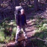
Day 1- The trail from Onion Valley to Kearsarge Pass is familiar, and the relatively gentle grade helps to ease into a long week of hiking. Carrying 35 pounds and working off a bunch of scotch from the night before makes things a little harder, so of course I took an extended break at my favorite spot next to Gilbert Lake. While here I ate the remains of a dinner sandwich from yesterday and geared myself up for the long switchbacks ahead. This pass has the best view in the Sierras, and while I was there I took some photos of a guy climbing the nearby rocks. I left a note on his backpack to contact me for copies and headed down the trail for a while, dropping 1800 feet of hard-earned elevation while joining the John Muir Trail near Charlotte Lake. I had a decision to make as I approached Glen Pass, so I walked past the last good campsite and tackled another high elevation section. The last mile of this trail gains 1000 feet and the frigid temperatures got me so cold I couldn’t even talk to another hiker when I reached the gap. From there I still had another two miles of downhill and I collapsed at the upper Rae Lake as the sun was long below the mountain range behind me. I was too tired to even eat, so I just slowly put up the tent and climbed inside to sleep. I was warm enough but I left my camera and the spare battery outside so both froze up and left me with very little power. For the rest of the week I would bring all the electronic stuff inside the tent with me - lesson learned. Actually I already knew this but forgot from being so tired.


I like to acknowledge John Muir for his work in preserving these areas.
DSC07248.JPG


Looking over Gilbert Lake after my morning snack.
DSC07259.JPG


Heart Lake.
DSC07262.JPG


Stopped here for another break to look at East Vidette Peak and refill on water from a little stream.
DSC07283.JPG


Bullfrog Lake.
DSC07286.JPG


Looking past Charlotte Lake down towards Kings Canyon.
DSC07295.JPG


Later part of the day, this is the hard part of Glen Pass.
DSC07311.JPG


Looking down from Glen Pass, Rae Lakes were already in the shadow.
DSC07324.JPG


Getting dark as I got to the outflow of Upper Rae Lake.
DSC07331.JPG


I believe it's a requirement to take a picture of the Painted Lady when passing this Rae Lake.
DSC07332.JPG


note- when I got to Bishop later that week I had a message from the hiker dude asking for his rock climbing photos, so I think I built up a little hiker karma.
"Argue for your limitations and sure enough they're yours".
Donald Shimoda
User avatar
JeffH
Posts: 1146
Joined: Sun Nov 28, 2010 7:09 am

Post by JeffH »

Day 2- I rose to some frozen pools next to the lake, and finally got on the trail once the sun warmed things up a bit. I took some extended breaks as I followed the lakes down this valley, it was great to just sit and relax next to a creek. I was a little surprised at my slow pace, taking nearly four hours walking the seven miles to the world-famous suspension bridge which of course prompted a real lunch break while visiting with lots of other hikers. After passing over Woods Creek I stepped onto new trail, following the creek along the JMT. Uphill all afternoon took a toll on me so I found a great spot near a ledge in the trees overlooking the canyon and cooked up a nice dinner. This would be my shortest day on the trail, attributed to the extra effort needed yesterday and some great views as I walked along the Rae Lakes, past Arrowhead and Dollar and then along and above Woods Creek.


Lower Rae Lake with Fin Dome behind.
DSC07337.JPG


Break time. This spot was too nice to pass up even though I had only walked a little over a mile.
IMG_9438.JPG


Dollar Lake. When I passed by here in 2015 a bear climbed out behind me near those rocks.
IMG_9440.JPG


Suspension bridge over Woods Creek.
IMG_9443.JPG


Virgin trail to me!
IMG_9449.JPG


The route ahead.
IMG_9450.JPG


Woods Creek waterslide.
IMG_9451.JPG


Woods Creek waterfall.
IMG_9457.JPG


Camp time. Those dark clouds remained behind me all week.
IMG_9461.JPG
"Argue for your limitations and sure enough they're yours".
Donald Shimoda
User avatar
JeffH
Posts: 1146
Joined: Sun Nov 28, 2010 7:09 am

Post by JeffH »

Day 3- Much better rested, I was having some breakfast when a couple of early hikers walked past my campsite on the trail a couple hundred feet way. I packed up and got on my way, only to run into them about an hour uphill so I stopped to chat for a long while. Taking off again, I was having a Snickers break when they appeared again, heading toward Pinchot Pass. We met up once again at the last stream crossing before the pass where we talked about old cars and hiking different trails. We all headed up the final stretch to Pinchot together, and then I settled in at Marjorie Lake to soak my feet and have some lunch while they forged ahead. Late in the afternoon I was looking at my guide and the next campsites were about two miles away, so I stopped at the junction of various Kings River forks, setting up camp near my two new companions who were introduced as Jim from Seattle and Chris from Yorkshire (UK). They are lifelong friends who have hiked around the world, both agree that no other trail has the same views and terrain of the JMT. After inspecting each other’s tents, we had dinner and then later sat together for some hot tea before retiring for the night. This campsite was next to the river so I had quite a bit of condensation inside my tent in the morning.


This was a day of "find the pass" as the trail switched directions. That is not Pinchot Pass, which is actually around that mountain to the left.
DSC07354.JPG


Looking back the way I came, from near Pinchot Pass.
DSC07365.JPG


View north from Pinchot.
DSC07368.JPG


Marjorie Lake.
DSC07371.JPG


One of the few days warm enough to soak my feet.
DSC07372.JPG


Plenty of rock hopping here.
DSC07375.JPG


The road goes on forever and the party never ends.... Mather Pass way up ahead.
DSC07377.JPG


Unnamed lake along the way, another excuse to have a Snickers break.
DSC07378.JPG


River at the South Fork Kings River junction, I camped just off to the left of this photo.
IMG_9462.JPG
"Argue for your limitations and sure enough they're yours".
Donald Shimoda
User avatar
JeffH
Posts: 1146
Joined: Sun Nov 28, 2010 7:09 am

Post by JeffH »

Day 4- Since everything was wet I stuffed the tent into my outside pocket and hit the trail before eating, planning to stop where I could dry things out in the morning sun. After about an hour I reached a nice meadow where I unpacked everything and also had some breakfast. Just in the time walking the moisture had turned to ice, another indicator of just how cold it was every night on this trip. After a really long break, I started moving again toward Mather Pass, and this is probably my favorite part of the trail. It is mostly above treeline, filled with small lakes and streams. Surrounded by high peaks, I could not tell exactly where the pass was located so after gentle uphill of about two miles I was at the base. It looks daunting from here, the mileage is about a mile but the rock wall is nearly vertical for about 500 feet. The trail is an engineering marvel, with a nice grade and still intact after about 100 years of weather and people tramping along. The descent from Mather Pass was not as enjoyable, mostly steep rock, high stairs and uneven footing. The Palisade Lakes were a nice distraction, and the trail leveled out for a couple of miles before going down the section known as the Golden Staircase. This was not fun, I was happy that I was not climbing but my knee was definitely hurting by the time I caught up to Jim and Chris. We spent another couple hours together which included a long break at a stream crossing and then we separated as they were heading past my trail junction. While scouting the limited places to sleep, I settled on the Middle Fork of Kings River, which was also my lowest elevation of the hike at just over 8000 feet. It also made this the warmest night of the trip as the temperature was about 30 degrees.


Frost on the grass as I left camp in the morning.
DSC07381.JPG


Drying stuff out while having some breakfast.
DSC07384.JPG


Another day of "find the pass" - Mather is the low spot on the right.
DSC07386.JPG


The nearly sheer wall of Mather looms ahead. I needed a Snickers break to be motivated for this one.
DSC07389.JPG


Looking back south from near the top of Mather Pass, trail switchbacks included.
DSC07401.JPG


Staggering up Mather. Actually a nice climb, did this mile in about 35 minutes.
DSC07402.JPG


North view from Mather.
DSC07404.JPG


Upper Palisade Lake.
DSC07411.JPG


The section below these 3 lakes is the Golden Staircase, which was my least favorite part of the trip as the downhill was hard on my old knees.
DSC07412.JPG


Very tame wildlife, this guy just stood on the trail for a while eyeing us before retreating to the trees.
DSC07418.JPG
"Argue for your limitations and sure enough they're yours".
Donald Shimoda
User avatar
JeffH
Posts: 1146
Joined: Sun Nov 28, 2010 7:09 am

Post by JeffH »

Day 5- Starting the day with a downhill walk of about two miles was a nice change, I celebrated with a long breakfast break at the fabulous Grouse Meadow. On reaching the next trail junction, I bid a fond farewell to the JMT and started up the familiar Dust Basin trail. I came down this route in 2019 so I knew that the lower part was in some nice shady trees. I took advantage with a Snickers break just before the sunny part, and then moved out into the open. At the bridge crossing I spent some time refilling with fresh stream water before going the next mile to the large lake in Dusy Basin. I had lunch while watching the fish go crazy leaping after mosquitos, I also visited with other hikers exploring the area or heading down to the JMT. Finally I convinced myself to head up again, and two miles later I reached my planned location at Lake 11360 (I’ve also seen it named Lake 11320). Having camped here before in 2015 I knew what to expect, and this time I was early enough to snag a great campsite. The wind caused some havoc setting up the tent, although I managed that task with plenty of daylight remaining. Somehow I just stared at the lake and other scenery for two hours, so I ate a quick dinner as the sun was setting and then crawled into the tent for my last night and highest campsite of the week. The wind blew steadily until about 4am, creating a fitful night of sleep.


Waterfall near where I camped.
DSC07422.JPG


Grouse Meadow. I didn't see any of these birds along the way.
DSC07426.JPG


Goodbye JMT.
DSC07431.JPG


Granite.
DSC07437.JPG


Last break in the shade as I was reaching treeline. Also my last full-size Snickers bar of the week.
DSC07441.JPG


Waterfall at the bridge on the Dusy Basin trail.
DSC07447.JPG


Lower lake in Dusy Basin. The fish were jumping here.
DSC07454.JPG


My stopping point for the day, unnamed on the maps so I will call it Lake 11370.
DSC07460.JPG


Sunset alpenglow.
IMG_9469.JPG
"Argue for your limitations and sure enough they're yours".
Donald Shimoda
User avatar
JeffH
Posts: 1146
Joined: Sun Nov 28, 2010 7:09 am

Post by JeffH »

Day 6- Because of the wind, I slept in a bit as the sun was nearly above the surrounding peaks while packing up my stuff. Another delayed breakfast meant I was on the trail relatively early and I reached Bishop Pass in less than one hour. Shortly after that I started to run into day-hikers, which I thought would be beneficial to my plan/need to hitchhike back into town to catch the last bus south this evening. Somewhere near Long Lake I sat down to eat and refill on water, and then it was just a short few miles to the trailhead at South Lake. I sat there for a long time with my thumb out but no one stopped to offer a ride. Since I had to be in Bishop by 6pm I started walking down the road and after an hour a local (Thanks Jay!) guy picked me up and brought me to the Vons in town. That gave me enough time to have a giant meal at Schat’s Roadhouse, which I recommend if staying in town and you can collapse into a hotel room immediately. I only got to sit in the park and read for a couple hours and all too soon it was time to catch the bus south. At the Mt Williamson motel in Independence they had a food truck serving up a chicken marsala dish, so the owner bought me a dinner plate as I was arriving shortly after the festivities (Thanks Lauralyn!).
On Saturday morning I met up with Mr and Mrs Rico, who were contemplating a summit of Mt Gould, so they kindly gave me a ride up to Onion Valley where I picked up the Escape and after filling all my water bottles headed home.

Just another great week in the Sierra Nevada, this completes my JMT sections and I still have a lot of places to visit.
67 miles, 14,950 feet gain and 15,400 feet lost (road section included). It's my longest trip yet.


Morning. It was cold enough that when I took my water out of the tent vestibule it froze in about 10 minutes.
DSC07463.JPG


Calm lake reflection.
DSC07464.JPG


Frozen section of the lake, this part is the lee side of the wind.
DSC07466.JPG


Sun coming up means it is time to hit the trail.
DSC07470.JPG


Nearing Bishop Pass.
DSC07474.JPG


Fifth pass of the week.
DSC07482.JPG


Bishop, Saddlerock, Long lakes.
DSC07484.JPG


Going down the Bishop Pass trail.
DSC07492.JPG


Bookend to the first picture, goodbye to John for a while.
DSC07495.JPG
"Argue for your limitations and sure enough they're yours".
Donald Shimoda
User avatar
jfr
Posts: 147
Joined: Sat Dec 12, 2009 3:01 pm

Post by jfr »

Excellent TR! Thanks for posting. That is one of the most scenic sections of the JMT, and one that I would gladly do again. Except maybe the long climb up into Dusy Basin. :D
My hiking trip reports: https://hikingtales.com/
User avatar
Sean
Posts: 3712
Joined: Wed Jul 27, 2011 12:32 pm

Post by Sean »

Thanks for the awesome report! Mather Pass sounds and looks amazing, even though it was hard on your knees. I love steps!

I had trouble sleeping once due to wind at Monarch Lake. Maybe ear plugs are the solution.
User avatar
Girl Hiker
Posts: 1297
Joined: Fri Apr 04, 2014 7:46 am

Post by Girl Hiker »

I enjoyed the pics!
User avatar
tekewin
Posts: 1183
Joined: Thu Apr 11, 2013 5:07 pm

Post by tekewin »

Too many great pics to single any of them out. What a huge trip!
User avatar
Uncle Rico
Posts: 1386
Joined: Thu Mar 20, 2008 7:48 pm

Post by Uncle Rico »

Amazing trip. Beautiful pics.
Post Reply