We hiked the main trail from San Gerardo de Rivas. Trailhead is at ~5000ft. The peak is at 12500ft. This is a lot, but many people want to do this, and most would have trouble without help. So they give you help:
- You're in a rainforest most of the time, so it's not hot, and you're not chugging water
- At 8000ft is the Llano Bonito convenience store with food, water and bathrooms
- At 11000ft is the Crestones base camp with food, water, bathrooms and beds. And shockingly: wifi.
So you can carry minimal water, minimal food and no camping stuff at all. It IS cold up on top, so you need to carry warm clothes (that you wouldn't be using at any other point during a Costa Rica trip). But even then there's a porter service you can use to haul your stuff up and/or down the mountain using horses. We didn't do that.
The trail is muddy, but well maintained. Mostly it sticks to a ridge-top, so oddly there aren't any natural water sources. But you don't need them! Most of the time you're in a cloud forest, but above 10000ft you pass into the Paramó, a drier region consisting mostly of brush.
We started a bit before dawn. KM 0:

The ample signage continues throughout (please give all your money to Banco Nacional). Initially the trail is STEEP:


And you get nice views early:


In the steeper areas the better-maintained human route is separated from the rougher horse route:

At KM 4 you officially cross into the national park:

At KM 7.5 (roughly half-way to the base camp) is Llano Bonito, the convenience store:

The one guy there works 5 days at a time, staying at the apartment on the top floor. Sadly, he has no wifi, and has to listen to the radio. Everything is hauled in by horse:

Past there is more steep trail through the cloud forest:

We didn't spend a lot of time looking for animals, although they're there. Lots of cool mushrooms, though. Here're some tiny ones growing on a thin layer of moss on a rock:

The start of the Paramó looks like this:

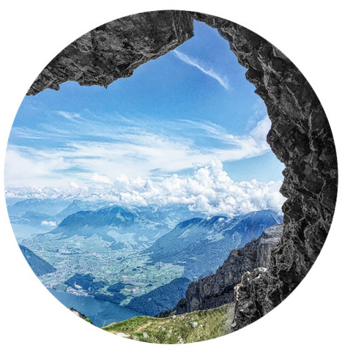
High up are dramatic views of clouds moving in/out of the valleys

And distant waterfalls

Eventually you can see the Crestones: a cool set of crags above the basecamp:

Each KM is marked with signs, and there are a few rest points along the way.


At ~ KM 12.5 is a water pipe next to a cool crag you're not allowed to climb

Then at KM 14 you get the first view of the Crestones base camp

We arrived at 12:30PM or so. The Costa Rica world cup game was about to start, and they actually brought out a TV to show it in the lodge. Tempting as that was, I've been looking at cool peaks for hours, and wanted to summit something. So after a break, we set off towards the Crestones to the East. A good, steep trail goes over there. It becomes less well-defined at the bare slabs near the top, but easy-enough. So far we've been very fortunate with the weather (no rain!) but here we entered the clouds, and it started drizzling. Eventually we made it to the "top" of Cerro Crestones


This is at the base of the highest needle, so it's not the top of anything. The rocks may not be climbed, but the word on the street is that they are bolted and chossy. It was really windy and cold on the ridge, and it looked like a storm might be about to roll in. But there was still time before sunset, and this wasn't a real peak, so I followed the ridge to the next real peak: Cerro Terbi. This is nearby, at 12336ft. So just barely lower than the high point of Cerro Chirripó, at ~ 12.5kft. The top was cold, wet, windy, and had zero views. Good-enough. On the descent back towards the base camp the clouds cleared, revealing a dramatic view of the Crestones needles

And with the better conditions came a stream of hikers wanting to see the sunset from the top. We weren't feeling the climb back up, though, so we missed out. Got back to the base camp shortly after the game ended. Costa Rica lost 2-4, after taking a 2-1 lead with ~20 min to go. Must have been a scene, but we missed out on that too. Whatever. We read the detailed covid-era instructions about proper greeting technique

We ate dinner, chatted with some other hikers, some of us took an ice-cold shower, and we went to bed. Got up at 3AM to hit the summit at sunrise. Eventually we could see the peak

The upper section has some easy class-2 climbing

Are we too late???

It was really windy and freezing cold (literally!) but we made it just in time!


Still getting incredibly lucky with the weather: it was cold, but not raining. Clouds covered both coasts, but the scene is still dramatic. I found a benchmark

And looked at the mountain lakes


and at Cerro Terbi and the Crestones where we were the previous day:

Mission completed, we began the net-7.5kft descent back into town. Somebody at the lodge saw a Tapir between the base camp and the peak maybe 20min after we passed by. It was probably in the bushes and we walked right by it! At least we found some cool lizards

And the cloud forest

And after a long, never-ending descent, we exited the park, and arrived back in town for a well-deserved dinner and shower.

Recommended!