
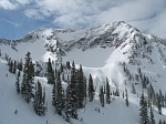
Here's our hike back in 2004 (10 years ago jeez), not great pics of the actual climb but you can see the apex of the ridge pretty well. The big exposure is North side I remember one spot where I moved to the left and looked to my left and it was all air. The apex of the ridge is the proper approach overall.
http://kathywing.smugmug.com/California ... /i-MMqcQpB
Strawberry Peak Routes
Haha, this was that day! You have a good memory Zé. The worst part was not knowing where I actually lost it. It could have been anywhere on that trail. Or someone could have picked it by then and been long gone. The odds of finding it seemed tiny. The other hikers told me, "Don't go back up. It's not worth it." No way, man! Of course I'm going. Privately, I wasn't sure if I even had enough water or the energy to do it again. I ended up hiking to where the trail gains the ridge and I came across a group of hikers who found it. I gave them some reward money to spread the good karma.

I did it a few months ago. Granted I climb a lot, but this was still extremely easy for anyone IMHO. There are ways around 'hard' spots. The paint on the rocks is still there.
Normally one faces in to downclimb, as this often means much better balance. I face out if it's very easy.
Normally one faces in to downclimb, as this often means much better balance. I face out if it's very easy.
-
OutdoorAbstract
- Posts: 32
- Joined: Thu Jan 22, 2009 4:43 am
I was there this morning and there is still a 'Trail Closed' sign at the beginning of the Colby Canyon trail to Strawberry. The two parking areas on that side of the road have large 'No Parking' signs posted. I descended the Red Box side then rode my bike (which I had deposited earlier at the Haramoknga Center) down ACH. Only saw one other person, we kind of spooked each other right at the top. I started walking at 5:20a which may have had something to do with the unpopulated trail.
I did Josephine Peak via the Josephine Peak fire road this morning...checked with the ranger station yesterday afternoon to confirm the fire road was open to hiking...it is, and is in fine shape...
Where the fire road reaches the ridge and you turn left to go to Josephine or right toward Strawberry, the narrow trail toward Strawberry did not have any signage indicating it was closed...so this might be a way to access the hard route to Strawberry...might be closed at top of Colby Canyon Trail, though, so still a good idea to check with the ranger station...
oldcoot

Climbed the Strawberry west ridge yesterday from Josephine Fire Road. As a rock climber, I would rate myself an advanced beginner, and I had no trouble getting up and down. The painted arrows help both ways. The rock is good and there are no tricky moves required. There are several places of airy exposure.
If you follow the ridge use trail, there is a 50-75' section of class 3 that goes over a bump long before you get near Strawberry. Just before the hard part, there is also a 100' class 2 notch you need to descend and ascend. Lots of bouldering and climbing fun. More in the trip report section.
If you follow the ridge use trail, there is a 50-75' section of class 3 that goes over a bump long before you get near Strawberry. Just before the hard part, there is also a 100' class 2 notch you need to descend and ascend. Lots of bouldering and climbing fun. More in the trip report section.
I think it all depends on how spooked you get by exposure. There are a few exposed spots, but they are not bad and the rock is very good. Between the first bump on the West Ridge and the Peak there was a lot of poodle dog bush last year. Does anyone know if it is still there threatening intrepid climbers?
-
janefontana
- Posts: 6
- Joined: Fri Jun 07, 2013 2:09 am
The USFS page says it's closed, but I thought they opened Strawberry Peak Trail. I know the Upper Big T part is closed, but what abou the Colby Cyn and Red Box Trails to the peak?

-
mcphersonm80
- Posts: 243
- Joined: Mon Aug 23, 2010 11:46 am
The trail from Red Box is open and in excellent condition if you want to approach from the East.
The Colby Trail is closed, but you can approach the West (i.e. fun Class 3) via the Josephine Fire Road which starts at Clear Creek junction. Head up the road to the Josephine/Strawberry saddle, take a very clear use trail across the ridge to the Colby saddle, then look for a far less obvious trial up the fun ridge. Trail above the first class 3 section is overgrown in spots with poodle dog bush, so be mindful of that.
The Colby Trail is closed, but you can approach the West (i.e. fun Class 3) via the Josephine Fire Road which starts at Clear Creek junction. Head up the road to the Josephine/Strawberry saddle, take a very clear use trail across the ridge to the Colby saddle, then look for a far less obvious trial up the fun ridge. Trail above the first class 3 section is overgrown in spots with poodle dog bush, so be mindful of that.

Mr. Maxon has been working on the Colby Canyon Trail. Cecelia and I helped him with an erosion problem today. Storm run off has been pouring out of a minor gully and spilling down the trail, so we cleared a bunch of debris and built a robust water bar out of large boulders at the crossing. Kristin Sabo made a smaller water bar below the big one and Cecelia cleared rocks. The trail is shaping up but still has lots of rocks on the upper sections. It's a good route for water lovers, especially right after a big storm. The waterfalls were rushing today, even the ephemeral ones. And the creek crossings posed a bit of a challenge initially but eased up after several hours of no rain.
- Large water bar at gully crossing.
- Small water bar below crossing.
- Waterfall on Colby Canyon Trail.