
Missing forum member (Colin Walker)
-
Paul Ayers
- Posts: 42
- Joined: Fri Sep 14, 2012 5:21 pm
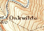
I contacted an acquaintance who likes to monitor SAR frequencies; for obvious reasons he shall remain nameless. At any rate he heard the discovery call the night of Tuesday 7/25; the coordinates given were 34.17985-117.99911. If you plug this in on next's days flight it looks like the attached. If you look at the three way-points just prior to the return flight, it takes 27 seconds to get from the first to the second point, but 1 minute 7 seconds to get from the 2nd to the third. I think that is when the pickup took place; from there the flight heads directly back to base.

-
Paul Ayers
- Posts: 42
- Joined: Fri Sep 14, 2012 5:21 pm
All indications are that he was recovered from the ravine where the marker is shown, on the west side of the main trail ridge. Until the autopsy report is issued, we won’t know cause of death; that may take up to 60 days. Basic information will be available free online at the Medical Examiner’s website.
-
Paul Ayers
- Posts: 42
- Joined: Fri Sep 14, 2012 5:21 pm
My current hypothesis on what happened. I think that Colin found the very nice 1933 aerial on FrameFinders showing what I believe to be a ca. 1925 switchback trail built by the City of Monrovia, that was more or less supplanted by a subsequent fire-break which ultimately became the main Clamshell Peak Trail. Whether he was just taking a look on his way to his ultimate destination, the ridge between Clamshell and Rankin, or he thought he would put a 1/2 day in and look just at the subject switchbacks, we'll never know. But I think its a fairly good bet that he was working on these switchbacks when things went wrong.
Attached is the 1933 aerial with a red circle indicating the location of the discovery call. I've also attached my attempt to draw the route of the switchback nearest that location of the discovery call on a 2022 aerial, with the location of call indicated. It is a safe assumption that Colin was found in the ravine from which the discovery call was made. I think it’s a fair hypothesis that Colin suffered a fall while crossing the ravine following either the bottom or top leg of the switchback. If a fall was involved, as opposed to some other cause, the only other explanation is he fell into the ravine off or near the main Clamshell Peak Trail, which is possible, but I feel less likely.
There is one other factor that plays into this. According to the PSN, the South Pasadena Deputy City Manager stated the remains were found “300’ down a ravine”. It is safe to assume the ravine the official is talking about is the same one where the discovery call was made. It would make sense that the 300’ down refers to down the ravine from the main ridge. The call location, however, is only 115’ feet down from the ridge line. One explanation for the discrepancy is that the remains were in fact 300’ down and the discovery call was made on the basis of an artifact or visual.
i was wondering about that! thank you.Paul Ayers wrote:
There is one other factor that plays into this. According to the PSN, the South Pasadena Deputy City Manager stated the remains were found “300’ down a ravine”. It is safe to assume the ravine the official is talking about is the same one where the discovery call was made. It would make sense that the 300’ down refers to down the ravine from the main ridge. The call location, however, is only 115’ feet down from the ridge line. One explanation for the discrepancy is that the remains were in fact 300’ down and the discovery call was made on the basis of an artifact or visual.
-
Paul Ayers
- Posts: 42
- Joined: Fri Sep 14, 2012 5:21 pm
The LA County Medical Examiner now has a page up for Colin; here is the link, https://mec.lacounty.gov/case-detail/?c ... 2023-09482 . The cause of death is "Deferred" pending further investigation.
updatedPaul Ayers wrote: ↑The LA County Medical Examiner now has a page up for Colin; here is the link, https://mec.lacounty.gov/case-detail/?c ... 2023-09482 . The cause of death is "Deferred" pending further investigation.
https://me.lacounty.gov/case-detail/?ca ... 2023-09482
