Allison Mine Trail

-
davantalus

- Posts: 203
- Joined: Mon Jun 08, 2009 9:09 am
I find the approach from down canyon much easier. The only thing you have to do is find the turnoff from canyon floor up the switchbacks.
I'd like to try this variation on Iron before things warm up much more. Does anyone know what conditions are of the trails from Allison\Heaton Saddle to Allison Mine and from there up the SW ridge to the peak? Just trying to figure out if this will be full x-country or if they're still being maintained by someone. I see a lot of info from '09-'10. Looks like around that point someone started some maintenance so I'm hoping there's still something established. Also does anyone have a .gpx on this route available?
Thanks,
Alan
Thanks,
Alan

I hiked from Heaton to the mine and back two Saturdays ago. The mine trail is passable, but not for the faint of heart. There are a few short slides that have to be crossed gingerly. A long stretch of the trail West of the mine is bybassed ABOVE the actual trail to get around some fairly robust overgrowth. Added bonus: TICKS ! One managed to get into my hip undiscovered until I was relaxing in bed later that evening. I trimmed back a few ambitious Yucca spears (again).
Good Luck and be careful.
Good Luck and be careful.

I think the main gully up to that ridge is below Allison Mine. I have been studying that route and was thinking of approaching from Allison Gulch. I explored Allison Gulch a short distance last fall, but my GPS went haywire in the steep canyon. No track to share.
Please post a report if you make the trip. I'd be very interested in your experience.
Please post a report if you make the trip. I'd be very interested in your experience.


-
davantalus
- Posts: 203
- Joined: Mon Jun 08, 2009 9:09 am
Vaguely on the same topic, anyone know conditions of the trail from Allison to Stanley Miller? I see it on the topo but have never seen any particularly obvious turnoff in that area.
-
Chicken Legs
- Posts: 33
- Joined: Fri Oct 19, 2007 12:04 am
Has anyone done this trail lately, the last posts I see are from 2014 and I see others on the web from 2009. But nothing recently. It might still be a little to warm for this one but thought I would check.
Thanks
Thanks
I don't have recent info, but do post an update if you try it. I was there in 2012 the last time, and given its state back then, I'd guess it's passable. Washouts would be the main point of concern, especially after the wet winter we had.Chicken Legs wrote: Has anyone done this trail lately, the last posts I see are from 2014 and I see others on the web from 2009. But nothing recently. It might still be a little to warm for this one but thought I would check.
I was there two or three years ago - I ascended Allison Gulch, checked out the mine then hiked to Allison saddle and descended the Heaton Flat trail. Just finding the point where the trail leaves the canyon bottom and climbs up out of the gulch was the hardest part. As long as you could find the correct starting point for the climb and follow the switchbacks, the trail was surprisingly good and not especially problematic. I made a couple of false starts, overshot it then backtracked and found the entrance to the trail. It seems that most of the time people fail to find the correct trail entrance and then climb some combination of eroded gullies or crumbly slopes to gain the trail high up. If I remember correctly, the entrance was behind a deadfall or snag of some kind and immediately started switchbacking up between some grassy bits - it was not obvious or out in the open like some of the other false detours. At the time, someone had even flagged some of the switchbacks with trail tape and the trail to Allison saddle was in relatively good shape as well. Good luck and let us know the conditions if you go!

I think it's about time for an update on the Allison Trail. Keith and I went up there yesterday. We took the overgrown and neglected Heaton Flat Trail to Coldwater Saddle. Frankly I felt like turning around already. My feets don't like me very much these days. But Keith and I pressed on, hoping to reach Allison Mine. Neither one of us has ever been there.
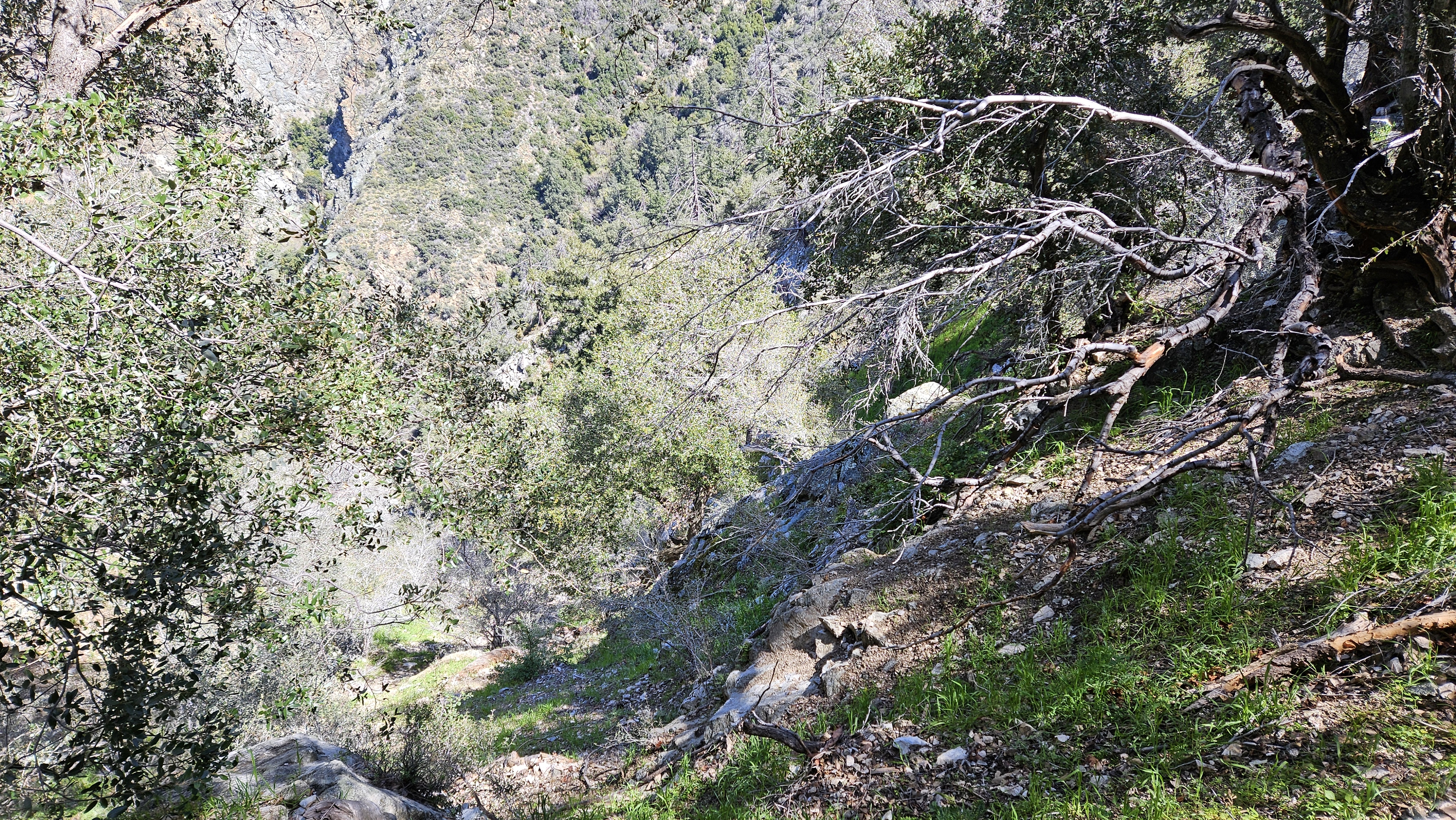
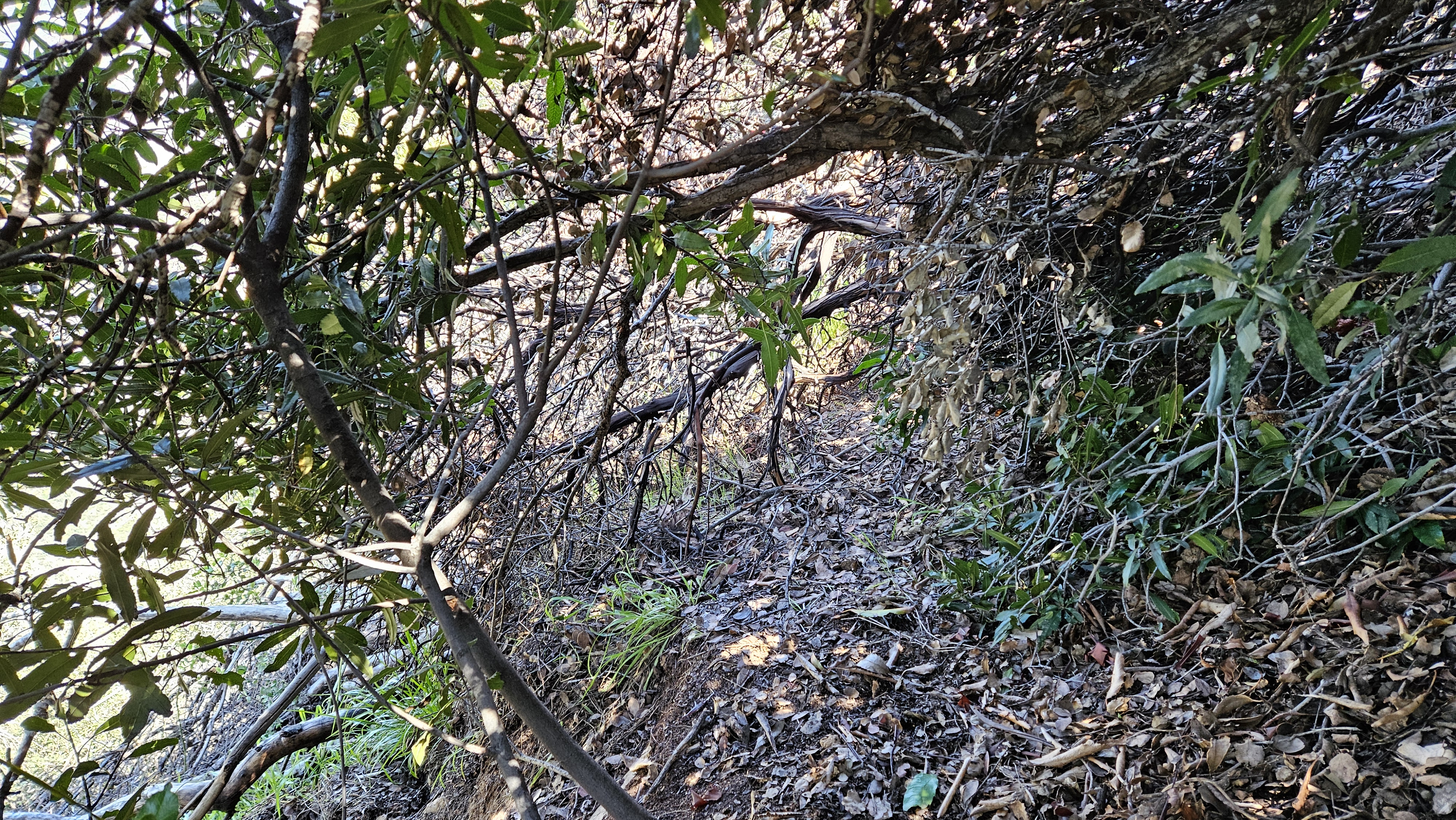
So we branched leftward and immediately tasted the awfulness of the Allison Mine Trail. Clearly it's been unmaintained for decades. Where it's not buried in slough or washed out, it's probably covered in thick brush or obstructed by deadfall. We were probably less than halfway to the mine when the danger level and slow progress totally sapped our motivation. As we approached the first substantial gully, the risk of taking a lethal fall increased nearly to our limits. Combined with the difficulty of route finding and making forward progress through heavy bushwhacking, Keith and I decided that enough was enough, and we turned around.
If you attempt this route, plan for a very, very long day, and probable failure.
I'm not surprised, but it's sad to hear. That trail was cool. Today there isn't a huge reason to go that way. To get to the Allison mine, the trail along Allison gulch is more direct and in better shape (at least the last time I've gone that way). The trail up to Heaton saddle from Heaton flat is in bad shape as well now?
It's in poor shape. Mild to moderate overgrowth with many tread issues, including rutting, rocks, and washouts. You don't have to crawl or risk your life, but you have to duck occasionally and constantly focus on foot placement.
-
Tom Kenney

- Posts: 342
- Joined: Sat Sep 29, 2007 7:51 pm
What?!? I still see good trailbed there. Quick pass with a McCloud, ship shape! 
When I was in Scouts, 'Allison' was a fear word. That was purt'near 45 years ago.
When I was in Scouts, 'Allison' was a fear word. That was purt'near 45 years ago.
It was still a fun day, and we learned something about Allison Trail. I think we could have eventually made it to the mine, but my guess is it would have required another 4 hours round trip. Very slow going. We did meet a baby rattlesnake just before Allison Saddle. Looks like it is trying to grow its first rattle. If I make another attempt, I'll try Allison Gulch. I didn't find the trail the only time I was in there. Less snow than I would have expected on the visible part of Iron.