

A recent TR with info on the Tom Sloan Trail.
I'm liking the name they use for Yucca - "stabby little asshole plants"
Hat tip to Modern Hiker.
Tom Sloan Trail
I generally substitute a F! for the YHikeUp wrote:I'm liking the name they use for Yucca - "stabby little asshole plants"
Or F!ucca #*%@
I'd like to see a GPS track for this trip... The trail while not in tip top shape was worked on last year and is quite passable
I wonder too if they were off trail. Or maybe the trail suffered the same fate as the west end of Mueller Tunnel this past spring.mattmaxon wrote:I'd like to see a GPS track for this trip... The trail while not in tip top shape was worked on last year and is quite passable
-
BrownMtnBob

- Posts: 96
- Joined: Mon Oct 15, 2012 1:55 pm
The trail from Dawn up to the Mt Lowe railway (and vice versa) is "closed so the forest can recover" (translation- we want this trail to go away, and if people don't use it for a little while, the forest will re-claim it....so it's off limits).

So in other words --- it is open.BrownMtnBob wrote: ↑The trail from Dawn up to the Mt Lowe railway (and vice versa) is "closed so the forest can recover" (translation- we want this trail to go away, and if people don't use it for a little while, the forest will re-claim it....so it's off limits).

If you're talking about the route up-canyon from Dawn Mine to Tom Sloan Saddle, then I'm pretty sure that's still in miserable to non-existent condition. However I believe the SGV meetup group tried to follow it recently:
http://www.meetup.com/SGV-Hikers/events/98291772/
There are a bunch of pictures. See 89-100.
I went down it summer of 2011. Some sections were completely washed away. Everything was overgrown. Watch out for poodle dog.
I was just at Tom Sloan Saddle on Saturday. This is what the trailhead looked like:

On the other hand, if you're talking about the trail from Dawn Mine up to the Mt. Lowe Road, that's a different story. Somebody is doing work on that trail, and it's in decent shape.
http://www.meetup.com/SGV-Hikers/events/98291772/
There are a bunch of pictures. See 89-100.
I went down it summer of 2011. Some sections were completely washed away. Everything was overgrown. Watch out for poodle dog.
I was just at Tom Sloan Saddle on Saturday. This is what the trailhead looked like:
On the other hand, if you're talking about the trail from Dawn Mine up to the Mt. Lowe Road, that's a different story. Somebody is doing work on that trail, and it's in decent shape.
-
BrownMtnBob
- Posts: 96
- Joined: Mon Oct 15, 2012 1:55 pm
For those of you who have been to Mt. Lowe Camp (aka Crystal Springs or Alpine Tavern).....there is a trail which heads westward, after walking through the campground area and past the restrooms. This trail goes just 100' or so, and then heads steeply up some rocks. Does this continue on anywhere?
From Mt Lowe Camp, how would one access the Tom Sloan Trail? I'm looking to camp at Lowe and then do Brown the following morning....but not 100% how to make it happen.
Thanks in advance!
Bob [/b]
From Mt Lowe Camp, how would one access the Tom Sloan Trail? I'm looking to camp at Lowe and then do Brown the following morning....but not 100% how to make it happen.
Thanks in advance!
Bob [/b]
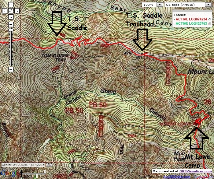
This map shows the Mt Lowe Trail Camp and Tom Sloane Trail/Saddle.
The red dashed lines are XC routes
Dashed purple are estimated XC routes or Forest Service GEODATA trail layer data
Thin Red, Black & Green are trails as hiked
Medium Red and Green are roads as hiked
I'd not depend on Tom Sloan Trail as I have not heard about it's condition post Station Fire. It was not very good before and I doubt the fire and years of closure have not improved it.
I haven't heard of anyone taking the old Tom Sloan Trail post-Station Fire, probably because much of it no longer exists. That westbound trail from the campground was probably a short path for the Alpine Tavern visitors. I believe the Tom Sloan began further up the road.BrownMtnBob wrote: ↑This trail goes just 100' or so, and then heads steeply up some rocks. Does this continue on anywhere?
From Mt Lowe Camp, how would one access the Tom Sloan Trail?
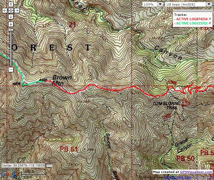
Anyway, what you want to take is the newer Tom Sloan Saddle Trail, which is in fine condition and will drop you about 800' to the saddle. This trail is clearly marked with a USFS sign and begins off of the Mt. Lowe Road approximately 1.4 miles after the campground. Where the road u-turns eastward toward Eaton Saddle, and where you first see Bear Canyon and the peaks above it (Disappointment, San Gabriel, Markham, Lowe), look left and find the trail to Tom Sloan Saddle. You pass a water tank on the right, then begin the descent.
When you get to the saddle, you'll be facing south with the old Sloan trailhead to your left. It's overgrown and doesn't look appealing. A sharp right reveals the clear Bear Canyon Trail. Now look right and find the Brown Mountain Trail heading up the ridge, immediately behind a bush which initially blocks your view of the trail. Once you get on the trail it's rather easy to follow but has a bit of simple rockclimbing.
Follow this path (which becomes a little faint near the end) for one mile to the long, flat summit of Brown Mountain. Near the end of the plateau, there is a large rock cairn with a plastic register can. Don't be confused by two or three prior large rock cairns, especially one a mere quarter or halfway along the trail.
If you make it to the summit, let me know if you find my sunglasses. Thanks.
-
BrownMtnBob
- Posts: 96
- Joined: Mon Oct 15, 2012 1:55 pm
Thanks Sean and Matt! I really appreciate it. Looks like that little trail that scrambles up rocks was some sort of short cut up to the old Sloan Trail (or maybe it's just nothing). I think I know where to go now. Much appreciated!
now tat i think of it it is to some ruins associated with the tavernBrownMtnBob wrote: ↑Thanks Sean and Matt! I really appreciate it. Looks like that little trail that scrambles up rocks was some sort of short cut up to the old Sloan Trail (or maybe it's just nothing). I think I know where to go now. Much appreciated!
-
cougarmagic

- Posts: 1409
- Joined: Wed May 07, 2008 5:21 pm
Matt's right. It was a trail to a caretaker's cabin. About all that's left is some concrete slab.

-
Uncle Rico

- Posts: 1386
- Joined: Thu Mar 20, 2008 7:48 pm
Jimbo- I haven't been on the trail, but I was at Tom Sloane saddle yesterday. The trail leading east toward Mt. Lowe looks a little more over-grown than in Sean's pic (see above) from a year ago. Doesn't appear to see much travel these days. The trail dropping into Bear Canyon looked a little better, although not much. I've got a pic I'll post later.
Jim, someone (not me) walked the trail a few months ago and did some work on it. Apparently the trail is in decent, passable shape, except for one short bit where a large bush/tree needs to be cleared. I haven't taken the trail yet, but I did check out the trailhead off the Lowe Road and it looks okay.
-
Uncle Rico
- Posts: 1386
- Joined: Thu Mar 20, 2008 7:48 pm
Trail leading to Mt. Lowe at Tom Sloane Saddle as of last Sunday.

It was perfectly passable before the fire. Last time I hiked it was probably 2007? In some spots, the old trail was blasted through rock ribs that poke out of the canyonside. I'd imagine those old trail cuts are probably still good. the drainages and softer spots in between them are probably another matter. The part that always seemed faint and confusing was where the trail eventually would meet up with the road near the mt. lowe camp/alpine tavern site. Even when it was in good shape, the trail just kind of vanished into an angled slope under the oak trees.
Once did a memorable shuttle dayhike through there starting from cobb estate to echo, onward to inspiration pt. via castle canyon, fire road to mt. lowe camp, from there via tom sloane trail to tom sloane saddle, then down bear canyon trail to switzer falls/gabrieleno trail continuing down the arroyo to oakwilde and up to ACH via dark canyon to a waiting car. Don't think I'll be doing that one again anytime soon.
Once did a memorable shuttle dayhike through there starting from cobb estate to echo, onward to inspiration pt. via castle canyon, fire road to mt. lowe camp, from there via tom sloane trail to tom sloane saddle, then down bear canyon trail to switzer falls/gabrieleno trail continuing down the arroyo to oakwilde and up to ACH via dark canyon to a waiting car. Don't think I'll be doing that one again anytime soon.
The Tom Sloan Trail was restored in 2018. After years of finding other things to do, I finally returned yesterday to see how it's holding up. The tread is mildly to moderately overgrown, with a short section of waist-high grass, where I caught a tick on my pants. Slide debris here and there, a couple downed trees, a couple giant boulders on the path, but all the rock work has survived, so no washouts or structural problems. Also, Tom Sloan Saddle is nice and clear with signage intact and a log to sit on, though I preferred the ground for a seat.