

I see on a local MeetUp that some people on this forum are going to the Allison Mine in a couple of weeks. Dunno if this is helpful, but here's what info I have:
Check out this map of the Allison Mine area. "A" marks the point where you turn off of the route to Iron Mtn. I call this Heaton Saddle, but I've also heard it called Allison Saddle. The trail contours around an E trending ridge to the Allison Mine ("B"). This trail is largely a major bush whack from "A" to "B" but it does lighten up some in the N facing spots. It gets worse every time I go. From the mine ("B"), I usually follow the old trail towards the Stanley-Miller Mine, but I leave the trail to the Stanley-Miller* at point "C" and follow the remains of an old trail that (more or less) parallels Allison Gulch. These trails are seriously overgrown and deteriorated, but I've been able to more or less follow them in the past. They're getting harder and harder to follow with each passing year. The trail paralleling Allison Gulch starts descending the ridge at point "D." There's a lot of loose slidey stuff and it's pretty steep, but it's not inordinately difficult. Don't count on the switchbacks shown on the map, although you may spot traces of the trail here and there. You rejoin Allison Gulch at "E" and hit the N Fork of the SG at "F" which is just above Swan Rock. Alternatively, you can go straight down from "B" to "E," but my understanding is that the section from "B" to "E" is technical canyoneering. See this post by Travis for some videos.
About the mine itself: None of the building shown on the map are there anymore, although the latrine was still standing -- with a wooden spool (empty) still in the toilet paper holder -- in the late 80's. No buildings are intact now. The old ore crusher was pretty cool. I think I found four shafts, one of which was upsteam of the others and full of water. I'm sure Mr. Blanchard's site will give you way more info than I can.
HJ
*Now if you want a real challenge, try going to the Stanley-Miller mine. I've only been there once, about 20 years ago. I went from the riverbed of the N fork up the side, scaling a lot of really steep stuff, some class 3, with a lot of brush. My map and compass work was "on" that day, and I got us in the vicinity of the mine. I spotted the chimney of an old miner's cabin sticking out of the brush, and that got me to the very mine itself. I didn't have much time, but what I saw was pretty cool. I was struck by a cast iron stove the size of an exective desk. There was also a lower shaft that was filled with old tin cans. It was pretty cool. I tried to go back some years later by taking the trail from the Allison mine, but that was bushwhack hell, and I aborted the trip.
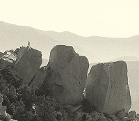
Allison Mine Trail

Trying for the other mine also is out of the question. A trip will already have the clock counting down, especially considering winter hours. While the gulch is not difficult or even intermediate,its still an organized hike...otherwise San Dimas could find the group in a precarious state, notwithstanding the permit that should be considered.
lol. I wonder who you could be referring to? 8)Hikin_Jim wrote:I see on a local MeetUp that some people on this forum are going to the Allison Mine in a couple of weeks. Dunno if this is helpful, but here's what info I have:
I am considering going up the gulch. But actually if you read Travis's TR about ascending Iron from the southwest ridge, he takes up this trail you speak of from the gulch.
http://www.gpsmountaineering.com/ironmo ... hwestridge
So actually maybe the trail up to Allison Mine is in decent shape. As for the Allison Mine trail from Coldwater Saddle, I checked out a small portion of it back when I did Iron in September, and that certainly is not seeing much use. My only question is which way is better to do the loop. I generally prefer to do the steeper stuff going up, so I am leaning toward going up from the gulch.Travis wrote: We quickly found the trail and was amazed at how well maintained it was. It had nice switchbacks with water drainage channels, yucca were nicely trimmed, a very nice trail indeed. This got me thinking why someone has been going through the trouble of maintaining this trail. It is not a frequent destination of hikers. My conclusion is that it is maintained by gold prospectors.
Oh, and I am definitely interested in checking out Stanley-Miller mine. That's next. I'm not sure about doing that as a day hike though. It will take a few hours just to hike up to the bridge let alone Iron Fork.
At some point I am also going to do an exploration of those mines beneath the San Antonio ridge. I'll hike to Coldwater saddle, then down the 1.2 mile trail to Coldwater canyon, then see where I can get from there.
At some point I am also going to do an exploration of those mines beneath the San Antonio ridge. I'll hike to Coldwater saddle, then down the 1.2 mile trail to Coldwater canyon, then see where I can get from there.
Ah, interesting. A lot of trails have been restored by enthusiasts of various stripes. That's very cool that someone has "rehabbed" the trail.Travis wrote: We quickly found the trail and was amazed at how well maintained it was. It had nice switchbacks with water drainage channels, yucca were nicely trimmed, a very nice trail indeed. This got me thinking why someone has been going through the trouble of maintaining this trail. It is not a frequent destination of hikers. My conclusion is that it is maintained by gold prospectors.
Dunno about the section from Heaton/Allison/Coldwater Saddle to Allison Mine. That section was seriously over grown last I was up which was maybe 2000 or 2001. Very cool if they re-opened the saddle to Allison section.
The old trail camp, now no longer maintained, at Iron Fork would be a good base of ops. I did it as a day hike, but it really didn't work well because I didn't have enough time to really explore the place.Zé wrote:Oh, and I am definitely interested in checking out Stanley-Miller mine. That's next. I'm not sure about doing that as a day hike though. It will take a few hours just to hike up to the bridge let alone Iron Fork.
I've been to the Baldora (marked as the "Widco" on the map), but the Eagle and the Gold Dollar (if I'm remembering my mine names correctly) would be tough indeed both in terms of brush but also perhaps just in terms of finding them. When I was last at the Baldora (late 80's), someone had restored one of the cabins. The rest of the buildings and works were in poor shape. The main shaft was completely caved in.Zé wrote:At some point I am also going to do an exploration of those mines beneath the San Antonio ridge. I'll hike to Coldwater saddle, then down the 1.2 mile trail to Coldwater canyon, then see where I can get from there.

This October I went up the Heaton Flats trail to the saddle and took the side trail to the mine. I too, was expecting a lot of bushwacking but was surprised to find many of the yuccas trimmed back. A couple of spots had washed-out sandy areas and maybe a few places where dense tree-cover obstruct the trail but other than that... I was impressed. My girlfriend and I found 4 horizontal mineshafts, one which was next to what appeared to be an old oven of some sort, which required us to crawl on our hands and knees the whole way through. I remember reading somewhere that there were other shafts on the other side of the creek, possibly vertical. We descended the Allison Gulch via the canyoneering route, which was a lot of fun. When we went, there were slings and rappel loops already in place on the route (some of which were very ill-placed). If you're doing the canyon, you might want to bring a good length of webbing to set up your own stuff. Doing the route this time of year might not be feasible if the creek is flowing as the rappels often directly follow the creek down the sides. Also, the final rappel is quite long. Our 60m rope only had a few meters to spare at the bottom, which ended in a thigh deep pool of water.
PS: the final rappel was awesome! oh, and your ropes/clothes/shoes WILL get wet, especially for this time of year.
PS: the final rappel was awesome! oh, and your ropes/clothes/shoes WILL get wet, especially for this time of year.
-
realshafer

- Posts: 10
- Joined: Sun Aug 24, 2008 6:04 pm
Just thought I'd chime in with a few pics of the Gold Dollar Mine I took back in September this year. I ended up there after a failed trip across the San Antonio Ridge, and suffice it to say that it completely sucked coming down the "Secondary Escape Route" as described on Brennen's page: http://www.dankat.com/advents/sanant.htm.
As we came down from the ridge we followed two sets of rusted cables, you can kind of see them in this pic.

The cables led us to a collapsed wooden structure and a closed shaft with raised tracks coming out of it.

What's left of the structure.

The cables ended at these trees.

A wheelbarrow or something like it.

Another angle of the structure.

We continued down from the mine hoping to find this shack that Brennen talks about in his description.

Didn't come across it though. I wouldn't suggest trying to find the mine, as it is really out of the way, and in my opinion, not worth the effort. There's hardly a trail to speak of, and what there is is confused with animal trails, and paths that look like trails but aren't. Also, on the way out of Coldwater Canyon, we passed the area on the map called "Wildman Ranch" which was deserted, but we were later stopped on the road by a guy in an suv that really laid into us for trespassing. We straightened things out with him, but he mentioned security cameras in the area and seemed pretty pissed that we were there (understandably, I'd have to agree).
As we came down from the ridge we followed two sets of rusted cables, you can kind of see them in this pic.
The cables led us to a collapsed wooden structure and a closed shaft with raised tracks coming out of it.
What's left of the structure.
The cables ended at these trees.
A wheelbarrow or something like it.
Another angle of the structure.
We continued down from the mine hoping to find this shack that Brennen talks about in his description.
Didn't come across it though. I wouldn't suggest trying to find the mine, as it is really out of the way, and in my opinion, not worth the effort. There's hardly a trail to speak of, and what there is is confused with animal trails, and paths that look like trails but aren't. Also, on the way out of Coldwater Canyon, we passed the area on the map called "Wildman Ranch" which was deserted, but we were later stopped on the road by a guy in an suv that really laid into us for trespassing. We straightened things out with him, but he mentioned security cameras in the area and seemed pretty pissed that we were there (understandably, I'd have to agree).
thanks for the photos realshafer. yeah i see may not be worth trying to check out those mines.
i'm really excited for this hike. i'll check out the area where there used to be a trail to Stanley Miller mine. now with the gps I'll put in some of those coordinates of where the trail "should" be although I'm guessing it will be totally gone.
I'm going to definitely plan a backpacking trip in a month or two to hike up the east fork past the narrows, camp out, and do some exploring around Stanley Miller mine. that should be great too
-
Sewellymon
- Posts: 97
- Joined: Tue Feb 12, 2008 8:55 pm
Ho Man,
I used to love to visit Coldwater Canyon and the Eagle and Gold Dollar mines (and San Antonio Ridge) in the late '70s. All those places felt like the end of the earth.
I've been to that tumble-down shack on 3 separate occasions. The “use” trail from Coldwater Canyon to the cabin was steep, but I recall no route-finding challenges. Although I must admit one time when I was up there, I was tripping hard on acid (in the fog) and was convinced the mist-soaked hillside right below San Antonio Ridge was going to avalanche on top of me. I spooked outta there and hiked non-stop down Coldwater Canyon and Cow Canyon back to the car in one straight shot.
The trail from Heaton Saddle to Coldwater Canyon used to have a washed out, exposed and dangerous section back in the 70’s. Has it been shored up?
I think I preferred hiking up Cow and Cattle Canyon. 10 miles vs 7 (via Heaton Saddle), but easier going.
And bummer that Widman Ranch/ Coldwater Canyon is off-limits. Sucks that the public had easement rights? But I guess the dirt road crosses their private land and that’s that? Anybody got any additional 411? Same thing with Thompson Ranch, right? Can’t pass it w/o big risk of bad scene from the owners? I guess far too much riff-raff from East Fork/ San Gab River made their way up canyon and wrought mayhem?
One rumor I had heard back in the mid 70’s was in the 50’s and maybe into the 70’s, one of the mine owners hired a native Indian to be a care-taker. Rumor was he lived up at one of ‘em (Baldora? Be the least isolated, though I always though it was Eagle or Gold Dollar…
So when we y’all going back up there?
best...paragraph...ever?!Sewellymon wrote: I've been to that tumble-down shack on 3 separate occasions. The “use” trail from Coldwater Canyon to the cabin was steep, but I recall no route-finding challenges. Although I must admit one time when I was up there, I was tripping hard on acid (in the fog) and was convinced the mist-soaked hillside right below San Antonio Ridge was going to avalanche on top of me. I spooked outta there and hiked non-stop down Coldwater Canyon and Cow Canyon back to the car in one straight shot.
That section has been shored up. For a while the USFS was promoting it as an active trail. It's been a few years since I've been down it, but last I was there it was quite passable.Sewellymon wrote: The trail from Heaton Saddle to Coldwater Canyon used to have a washed out, exposed and dangerous section back in the 70’s. Has it been shored up?
There is a public right of way. The problem is that someone has to sue to have it opened. So far, no one has done so. The USFS is super whimpy about preserving public rights of way. On multiple occasions over the years, they've closed historic trails because a land owner has complained. If the trail has been used for more than seven continuous years, it becomes a public right of way.Sewellymon wrote: And bummer that Widman Ranch/ Coldwater Canyon is off-limits. Sucks that the public had easement rights? But I guess the dirt road crosses their private land and that’s that? Anybody got any additional 411?
-
Sewellymon
- Posts: 97
- Joined: Tue Feb 12, 2008 8:55 pm
Thnx Ze! But what I very distinctly recall as a 17 yr old hoofing up Upper Coldwater Canyon as I was starting my "trip" was what I really wanted is to be with a girl nakked and having sex in those woods, under that altered state. Versus alone without another soul within many miles....
So what's the 411? I cannot mt bike ride down from Cow Canyon Saddle because Thomson Ranch ? Or they OK w hikers? But if I go up Coldwater Canyon, the deal killer is Widman Ranch? And can I enter from East Fork San Gab River, or is that approach off-limits?
Please don't be shy. We're an open minded group here.Sewellymon wrote:Thnx Ze! But what I very distinctly recall as a 17 yr old hoofing up Upper Coldwater Canyon as I was starting my "trip" was what I really wanted is to be with a girl nakked and having sex in those woods, under that altered state. Versus alone without another soul within many miles....Zé wrote: best...paragraph...ever?!
You can enter the upper Coldwater area via Heaton Saddle, but you can't go downstream from where the trail from the saddle drops into the canyon. Both Widman and Thompson Ranches are no trespassing zones, no hikers, no bikers, and no anyone.Sewellymon wrote:So what's the 411? I cannot mt bike ride down from Cow Canyon Saddle because Thomson Ranch ? Or they OK w hikers? But if I go up Coldwater Canyon, the deal killer is Widman Ranch? And can I enter from East Fork San Gab River, or is that approach off-limits?
Jim, is the Baldora mine worth visiting at all? I've heard from someone else who says Dry Gulch isn't too bad.
As for the other two, it would seem to be a pain to get to them, although Sewellymon remembers it not being too bad- he always was, ahem, under the influence- so I am curious.
As for the other two, it would seem to be a pain to get to them, although Sewellymon remembers it not being too bad- he always was, ahem, under the influence- so I am curious.
The Baldora (aka "Widco" per the topo map) isn't bad to get to as I recall. If you go up the Heaton Flats Trail and turn right at Heaton/Allison/Coldwater (pick your favorite name) Saddle instead of left to the Allison or straight to Big Iron, you'll go down the remains of a trail that eventually turns into a road. From where the road hits the bottom of the canyon, it's not too far nor is it too difficult to head up the drainage to the Baldora. The shafts that I found were completely collapsed. There were several mining buildings still standing (more or less) and one cabin that had been restored by someone. I think mines where the shafts are still intact or have extensive buildings and/or machinery are more interesting. The Allison, for example, is more interesting and more accessible, but the Baldora is worth checking out since it's not all that much harder to get to than the Allison.
One word of warning: I have not been to the Baldora since the turn of the century (doesn't that sound dramatic).
One word of warning: I have not been to the Baldora since the turn of the century (doesn't that sound dramatic).
Ok so on my birthday weekend my wife and I attempted to make it to Allison mine via Heaton flats trail. We had no problem finding the Allison Mine trail about 5 miles in, it seems someone has opened the entrance.
The "trail" is more like a faint path on a loose and crumbling hillside with few areas to actually stand, mostly your holding on. It faces west, first it seemed to cut right (north/nw) and then began to switchback down the hill side (west). We only got down about 4 levels of the switchback when we hit a part that was completely washed out, the only way to continue was by sliding down a very steep and rocky wash to continue the faint trail. My wife at this point stood atop a harvester ant hill and got attacked, she nearly fell in a panic and at this point I decided it best to abort. Unless the trail got better after this point, it seems you might need a rope to safely get back up. Does this sound right for those that have made it? Wrong trail? Does it get any better? (cant imagine 2-3 miles of this to the mine) Wrong way? I want to make a second attempt shortly!
There is no water up there, the trail is fully exposed and we had to hike all the way back to heaton flats, 10+ miles , 2000+ Ft elevation gain to spend the night at heaton flats Good times lol
The "trail" is more like a faint path on a loose and crumbling hillside with few areas to actually stand, mostly your holding on. It faces west, first it seemed to cut right (north/nw) and then began to switchback down the hill side (west). We only got down about 4 levels of the switchback when we hit a part that was completely washed out, the only way to continue was by sliding down a very steep and rocky wash to continue the faint trail. My wife at this point stood atop a harvester ant hill and got attacked, she nearly fell in a panic and at this point I decided it best to abort. Unless the trail got better after this point, it seems you might need a rope to safely get back up. Does this sound right for those that have made it? Wrong trail? Does it get any better? (cant imagine 2-3 miles of this to the mine) Wrong way? I want to make a second attempt shortly!
There is no water up there, the trail is fully exposed and we had to hike all the way back to heaton flats, 10+ miles , 2000+ Ft elevation gain to spend the night at heaton flats
it's not an "official" trail.
Rather it is a "USE" trail that has been improved here and there over the years by whomever had the time, energy, and inclination to do it.
But that aside you are in a natural area, with many hazards. You need to be aware of the hazards. Be able to determine what your abilities are . Or more importantly what your limitations are.
Then not exceed your abilities / level of risk tolerance. We all have different levels of risk tolerance.
Going into a natural area has inherent dangers. Insects, Flora, Fauna, Geologic, and more importantly encounters with humans
This isn't Disney Land where all danger has been eliminated and you will be safe as a babe in it's mothers arms
We've all had learning experiences over the years. Some good, some not but we live and learn.
We enjoy the natural places BECAUSE they are just that. We like to marvel at the attempts to extract minerals. See the folly of the bridge to nowhere etc... We are vistors there mother nature is in charge and she can be cruel to any creature that isn't aware.
-
moppychris

- Posts: 87
- Joined: Mon Sep 07, 2009 12:56 pm
I disagree. Disney Land is probably more dangerous. Look at what disney land and it's movies have done to children, made them spoiled and rotten monsters, then look at what nature has done...made them better human beings.
Most trails in this mountain range are not like yosemite trails, hwys for hundreds of peoples per day. The beauty of these trails is how naturally rugged they are. These trails may seem shitty to some people, and that is just their perception.
To answer your question, from what you described, you were not on the trail. The trail has a long history, who cares if its unmaintained or not, its probably tired.
-Fris
Not sure what your implying but I routinely like to go into areas with many hazards, I understand and accept them and do my best to be prepared. I have been "mountaineering" for many years since I was a child. My wife is learning and I did not expect her reaction to the ants, we had a long talk about how it put us both in danger.mattmaxon wrote: ↑it's not an "official" trail.
Rather it is a "USE" trail that has been improved here and there over the years by whomever had the time, energy, and inclination to do it.
But that aside you are in a natural area, with many hazards. You need to be aware of the hazards. Be able to determine what your abilities are . Or more importantly what your limitations are.
Then not exceed your abilities / level of risk tolerance. We all have different levels of risk tolerance.
Going into a natural area has inherent dangers. Insects, Flora, Fauna, Geologic, and more importantly encounters with humans
This isn't Disney Land where all danger has been eliminated and you will be safe as a babe in it's mothers arms
We've all had learning experiences over the years. Some good, some not but we live and learn.
We enjoy the natural places BECAUSE they are just that. We like to marvel at the attempts to extract minerals. See the folly of the bridge to nowhere etc... We are vistors there mother nature is in charge and she can be cruel to any creature that isn't aware.
I understand your trying to make sure an inexperienced hiker does not go beyond his limits but the whole Disneyland remark was sorta insulting. I guess you expected me to outline my past experience before asking?
I am fully aware of what the trail is, im asking is the whole trail as bad as the beginning? Does it sound like it was the right trail, it faced west just after Heaton saddle? Are there other sections that are washed out enough to need rope to get back up? Does the trail switchback all the way to the mine or do I start to travel in a general direction at some point?
Just looking for a better idea of what to expect and discuss this awesome location!

I've been on the Allison Mine trail many times and though it's crappy in places, It was never as bad as your report indicates. Either it's gotten worse, or you may have managed to wander off of it. Have a gander at
https://eispiraten.com/a ... ht=allison
and see if our track from the Heaton / Iron Mountain trail jibes with yours.
I would certainly heed Mr. Maxon's warnings, though the beauty of this area high above the East Fork is quite captivating.
https://eispiraten.com/a ... ht=allison
and see if our track from the Heaton / Iron Mountain trail jibes with yours.
I would certainly heed Mr. Maxon's warnings, though the beauty of this area high above the East Fork is quite captivating.
I was not intimidated by the trail, I like to go where few others have. My wife doesnt have the experience I do and when she started flipping out I felt it best to abort the mission for her safety.moppychris wrote: ↑I disagree. Disney Land is probably more dangerous. Look at what disney land and it's movies have done to children, made them spoiled and rotten monsters, then look at what nature has done...made them better human beings.
Most trails in this mountain range are not like yosemite trails, hwys for hundreds of peoples per day. The beauty of these trails is how naturally rugged they are. These trails may seem shitty to some people, and that is just their perception.
To answer your question, from what you described, you were on the trail. The trail has a long history, who cares if its unmaintained or not, its probably tired.
-Fris
Cool have you ever been down it? If so, could you take a shot at the questions in my second post?

Relax.........
See the link below too to compare/figure out what elevation changes and directions you need to travel in order to get to the mine...
http://socalhikes.com/2009/01/east-fork ... lat-trail/
See the link below too to compare/figure out what elevation changes and directions you need to travel in order to get to the mine...
http://socalhikes.com/2009/01/east-fork ... lat-trail/
I'm not implying anything, just making a statement
I don't know you or your level of experience etc...
You seemed to be asking some pretty basic questions. I just wanted to make a clear statement about what is out there to what appeared to be an inexperienced outdoors person.
SInce you where offended I sincerely apologize
As we all know you can get into serious trouble fast if you are not cautious
I checked out your post, I have not read the whole thread but im not sure how I could compare our trip, really great photos btw!Elwood wrote: ↑I've been on the Allison Mine trail many times and though it's crappy in places, It was never as bad as your report indicates. Either it's gotten worse, or you may have managed to wander off of it. Have a gander at
https://eispiraten.com/a ... ht=allison
and see if our track from the Heaton / Iron Mountain trail jibes with yours.
I would certainly heed Mr. Maxon's warnings, though the beauty of this area high above the East Fork is quite captivating.
The trail opening is really clear, about ten feet down the trail you come to a tree with a small flat spot created by derbis caught between the hillside and slope. Then you cross a steep area with no signs of a trail about 15-20 feet wide to anther area between a rock formation and trees. This is the beginning of the switchback, which is pretty easy to recognize. We followed the vauge switchback down about 4 steep levels where there was a complete washout about 8-9 feet before what looked like anther piece of the trail below and this is where I gave up. Does it sound like I lost the trail by any chance?
Yea im a high strung guy, sorry I try not to come off that way. That trip is from Allison gulch, its a different approach, i guess ill get out the topo and do the homework myself if the trail really is that hard to follow.HikeUp wrote: ↑Relax.........
See the link below too to compare/figure out what elevation changes and directions you need to travel in order to get to the mine...
http://socalhikes.com/2009/01/east-fork ... lat-trail/
The report clearly has a map with a gps trace doing the entire loop.Pata wrote: ↑Yea im a high strung guy, sorry I try not to come off that way. That trip is from Allison gulch, its a different approach, i guess ill get out the topo and do the homework myself if the trail really is that hard to follow.HikeUp wrote: ↑Relax.........
See the link below too to compare/figure out what elevation changes and directions you need to travel in order to get to the mine...
http://socalhikes.com/2009/01/east-fork ... lat-trail/
There are no switchback on that portion of the old Highline trail. I suspect you got off track.