
Eaton Canyon Trails
Let's say I want to go past the first falls in Eaton canyon. And let's say Their is no way I will ever take that ridge like I did at 13, and almost died,...and still quiver at the thought. Is there a reasonable way to hike around, or drop in from anywhere? I am not talking about way up like Idlehour. I did try some road to nowhere from Henninger, but got the quivers somewhere up at a turn when it became tight with a 500 foot drop, and turned around

Here's a map of Eaton Canyon -- the section above Henninger Flats but below Idlehour.
I've marked out a route in red with a little blue telephone by it. That's called the "Telephone Trail" because a phone line used to go along it.
It goes in more or less followable shape to the saddle at about 2600'. The trail (an old road) basically stops there, but there's a fairly tentative faint path that continues a bit past the saddle. There's a very steep drop in where I've placed the icon of a guy slipping and falling. You can do it without ropes/gear, but I'm not sure it's a good idea. I've done this route.
Looking at the map, I can see other routes that might go. I haven't tried any of them. You may be able to come up with your own as well. It's pretty steep over there.
Good luck,
HJ
Hey Hikin Jim. Yes, Telephone trail is the one I tried, and turned back from. The far corner as I remember gets very narrow at a sliding rocks area. So Its not only narrow, but the ground under your feet is not stable, with a forever drop. (the kind of drop you don't look at while moving). I have a rule. No risk taking if the odds are worse than 1 in 50,000. I figured I might slip one out of 500 times, with a high 50% probability of being unable to stop, making it a 1/10 of 1% chance of dying. (One in one thousand) In the scheme of life, that is a risk. You would live less than three years doing that everyday. I have kids ya know....
Thanks for the map, but the link came up nothing....unless you were showing the north pole in a snowstorm.
I learned about the telephone trail from a webpage I can't find right now. The old timer explained all the old trails going back to the 1940's. He also mentioned something about a parking lot on that road, or the other one directly above Henninger on the East side.
Well, like I say, that drop in isn't for the faint of heart (without equipment). Very loose and slidey.
The map link works as I try it just now. Try refreshing your screen. Caltopo gets stuck some times.
Some of those other routes are worth looking at although I haven't tried them. The one with the blue dot by it looks like it would not need equipment.
HJ
The map link works as I try it just now. Try refreshing your screen. Caltopo gets stuck some times.
Some of those other routes are worth looking at although I haven't tried them. The one with the blue dot by it looks like it would not need equipment.
HJ
-
cougarmagic

- Posts: 1409
- Joined: Wed May 07, 2008 5:21 pm
Hey fort, I applaud your conservative nature about dangerous routes.
The telephone trail isn't too bad, overall. It gets used enough that the 'trail' is pretty stable. However, if you hiked it, and took the steep and loose drop-in into Eaton, you could only go upstream. The technical part of Eaton starts immediately downstream of the drop-in.
There is a really nice non-technical section of Eaton canyon in the middle, between the drop-in and the lower two waterfalls (and a few smaller falls). Canyoneers don't like this part, since it's 'just' hiking, but it's very beautiful. I haven't found a way down into it though, seems like very thick brush and poison oak down from Henninger, any way you cut it.
I'd say, go to Idlehour and hike down canyon from there, but unfortunately without ropes you can't get to see much of the canyon.
The drop in north of the saddle the old road leads to, looking back up (taken in the middle).
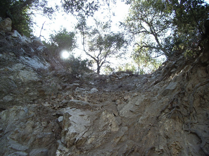
The drop in, looking down (taken in the middle).
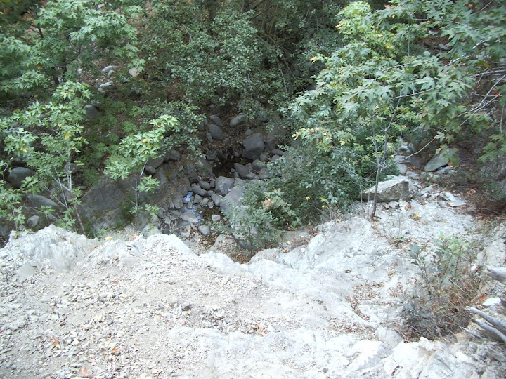
Pretty sketchy w/o gear.
The canyon, once you're in it, is very negotiable from there to Idlehour, or at least it was in 2009.
HJ
The drop in, looking down (taken in the middle).
Pretty sketchy w/o gear.
The canyon, once you're in it, is very negotiable from there to Idlehour, or at least it was in 2009.
HJ
The rumors are flying fast and furious that there will be some kind of closure imposed by the Forest Service in Eaton Canyon effective July 1, 2014, presumably in the area where people keep getting themselves killed. Details are sketchy (pretty much non-existent). Anybody got anything solid on this?
The problem of course is that a closure would affect competent canyoneers, not just the idjits that go without a clue.
HJ
The problem of course is that a closure would affect competent canyoneers, not just the idjits that go without a clue.
HJ

I dont think we should be spreading any rumors like others are.
Its incredulous cause as far as what has been posted, someone talked to someone at the forest service who said they might have heard about it. I think most people on here know how reliable that is.
It would take a major undertaking to close Eaton. It has been tried before with fences, but that didnt work. It would be HIGHLY unpopular.
The rumor is that the canyoneering section is the only one to be closed(to Idlehour perhaps). Too bad the death route is not above the waterfall. It starts before(downstream) of the falls. In other words, there is a lot of ignorance here.
Lastly this subject was deliberated last year. Yes, Judy Chu pushed for the closure for her cronies then . Yes, shes doing it again and demanding "safer trails" because of the recent memorial of the death of an asian-american gal last year....and she can use that to poll for her legislation.
-
cougarmagic
- Posts: 1409
- Joined: Wed May 07, 2008 5:21 pm
Heres some links:
http://www.sgvtribune.com/government-an ... -area-bill
"Chu spoke of hikers who have fallen and died in Eaton Canyon in northeast Pasadena, and in the Chantry Flat area of the forest above Sierra Madre and Arcadia, saying a National Park Service presence would help prevent such falls by adding Park Service rangers and better management practices......Those invited to the staged event included a wide range of supporters, from cities, the Los Angeles County Department of Parks and Recreation, retail water agencies and labor and job-training groups who see dollar signs not only for the forest but for park-poor communities in urban Los Angeles and San Bernardino counties...."
http://www.sbsun.com/government-and-pol ... o-congress
"....Mark Masaoka, the policy director of the Asian Pacific Policy and Planning Council, an umbrella group of 40 Asian-American organizations including the Asian Youth Center and the Chinatown Service Center, said many Asian Americans need a safer forest experience.
He noted the tragic death of 17-year-old Mark Keppel High School student Esther Suen, who fell 200 feet to her death while hiking Eaton Canyon in northeast Pasadena during spring break in March 2013.
“We are involved because we see the potential for increased resources,” Masaoka said Wednesday. “We want to make trails safer and more accessible, like you’d see at national parks.”....."
I don't think we should be spreading rumors either -- hence my post. I was hoping someone could post something solid.
And "closing" Eaton will be oh-so-highly effective I'm sure. But first we should put up a sign that says "please obey all signs".
HJ
And "closing" Eaton will be oh-so-highly effective I'm sure. But first we should put up a sign that says "please obey all signs".
HJ
-
cougarmagic
- Posts: 1409
- Joined: Wed May 07, 2008 5:21 pm
You should see my email inbox right now!
I have it nailed down to either Elvis or Obama behind the closure, and the reason being to protect the endangered San Gabriel Yeti.
-
Uncle Rico

- Posts: 1386
- Joined: Thu Mar 20, 2008 7:48 pm
Coming to a trail near you...“We want to make trails safer and more accessible, like you’d see at national parks.”....."
-
cougarmagic
- Posts: 1409
- Joined: Wed May 07, 2008 5:21 pm
There are no plans for closure of Eaton Canyon, via District Ranger Mike McIntyre, today 6/16/14.


JUDY CHU, AND THE LAND GRAB IS ALWAYS RELATED TO AGENDA 21.
PART OF THE 650,000 ACRES IS ALSO FOR THE "Environmental Justice"
MOVEMENT. basically AN AFIRMATIVE ACTION FOR LAND, WHICH ULTIMATELY INVOLVES AGENDA 21.
"Proponents of environmental justice generally view the environment as encompassing "where we live, work, and play" (some definitions also include 'pray' and 'learn') and seek to redress inequitable distributions of environmental burdens (such as pollution, industrial facilities, and crime)."
WIKIPEDIA
That mean that every single road, waterway, transportation and more would all be controlled because it is how access is made available for those who are "unjustly" not able to access the mountains as anyone else.
http://gulagbound.com/37479/judy-chu-ex ... communist/
http://mtmotorstables.blogspot.com/2013 ... u-and.html
SHE IS ALSO ON THE RURAL COUNCIL
http://www.theblaze.com/stories/2011/06 ... agenda-21/
But don't get me started.......sorry, couldn't help it.
Well, I don't know anything about "Agenda 21" (is it related to Area 51?),  but clearly if there are maps being drawn and mock ups of proposed closure notices then there is a serious closure discussion occurring. That said, I don't believe that any "go" decision has been made on closing Eaton Canyon above the first (lowest) falls.
HJ
HJ
-
cougarmagic
- Posts: 1409
- Joined: Wed May 07, 2008 5:21 pm
