

It was kind of funny going to Kauai with the news that Eaton canyon was being semi-closed to canyoneers.
It wasnt long before encountering a lame closed area on Kauai. And that would be typical....a nanny state where everywhere natural was so dangerous. This extreme distrust of anything natural is instilled in children and the people. Control of the market by helicopter pilots, boat operators,etc. There were so many closed areas and no police....there was one lifeguard bullhorning some people who dared to stray onto rocks that were coned off.
And then I get an update from the 'canyoneers' that we are supposed to sport a fake grin smile and do a clown chaka hand wave at ANF rangers.
Eaton Canyon Trails
Taco wrote: ↑ ]All I think one should really do is place a sign that talks about this. It's then up to people to be mature and know when to turn back, or say no completely[/quote ]
Aside from that sign being covered in graffiti within 2 hours after it's plopped into the ground ---- it doesn't seem to convey much of a threat or scare in my eyes.
I'm sure the forest service can't get tooooooo graphic with their graphics but that silhouette of the person falling on the sign doesn't even scare a chicken like me so i can only imagine how much a gutsy 20 year old with very little fear or knowledge of a crumbling cliffside would scoff at that sign.
Hell, as obvious and horrific as drinking and driving disasters are - we can't even stop that shit from happening...so throw in some pretty trees, sunshine, warm temperatures and the anticipation of reaching a waterfall and we really have a situation where that sign might stop a few but not many....
Aside from gruesome photos on the sign, the least they could do is put the $$$$$$$$ amount of the fine in the brightest and largest font possible and hope that info hits them on the wallet they won't be landing on...
I went up to the 2nd waterfall this past weekend. I did not go the exact way in the YouTube videos. I debated whether to post this TR, but I wanted to give some observations.
It is impossible to accidentally wander onto this route. The beginning is not a side trail that you just stumble upon. To be on this route requires very deliberate action from the very beginning. It’s not fair to blame the Forest Service or anyone else for not making this “safe.” Everyone knows this route is not normal and it is very obvious this is unsafe after just 1 minute on this route. I agree with Taco that it's up to people to be mature and know when to turn back, or say no completely.
There is a lot of exposure for a Class 3 climb. Because the sides of the ridge are loose and slope off quickly or go vertical, if you slip, you will start to fall very fast. If you don’t enter free fall, you will probably tumble and impact the rocky walls before reaching the canyon bottom.
The 2nd waterfall was just a trickle. The whole area was pretty bad with graffiti and trash everywhere...even underwear (what?).
Going down is harder than going up. Down climbing requires more skill and care about where to place hand and foot holds. It's also possible to get lost and cliff out if you're inexperienced. Down climbing and traversing is probably where people fall. They climb up without thinking about how they will get back down. When going down you have to stare right at the exposure. This can freak you out, leading to possible mistakes. There is really is no second chance after making a mistake. You will probably fall immediately off the ridge after a slip.

-
cougarmagic

- Posts: 1409
- Joined: Wed May 07, 2008 5:21 pm
The closed signs went Wednesday, July 30. They said warnings for a while, then up to $5,000 fine, and six months jail. I am waiting for homeland security aiming sharpshooters, with the tanks to come blazing in with Blackhawks. Police state expanding everyday.
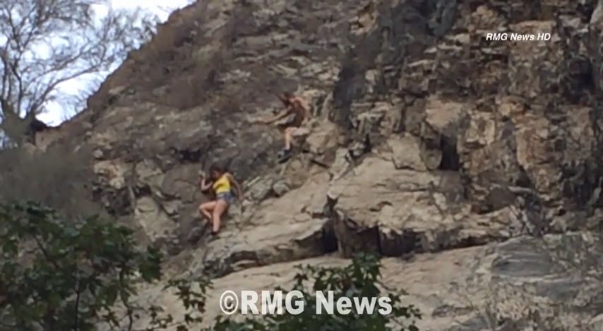
I was watching the morning local news today on KABC and they showed some video of a young women falling from the ridge yesterday, just as the signs were being put up. The video was pretty dramatic. The women was on the side of the cliff, well below the ridge. She lost her footing and quickly fell before a tree barely caught her leg and stopped her fall. A helicopter then came in and airlifted her off the cliff and you could see her legs were all cut up from the fall. She's very lucky. Without that tree, she would have fallen all the way to the bottom of the canyon. Here's the story, but I can't find the video online:
http://abc7.com/news/eaton-canyon-upper ... y-/229268/
http://abc7.com/news/eaton-canyon-upper ... y-/229268/
-
Uncle Rico

- Posts: 1386
- Joined: Thu Mar 20, 2008 7:48 pm
'Hikers' like this is why that stretch could be renamed 'Eat It Canyon'...
So where she fell ---- is that on the north side of the 'razorback' ?
I guess even if you COULD post this video at the base of the 'razorback' many 'hikers' would say "seeee, she didn't die, she's OK, what's the problem ?"
As its been suggested here by others, I sure wish the forest service could set up a permit system that would allow qualified canyoneers to keep doing their thing. But at the risk of sounding like 'Hiking Hitler' yeah, I'd say if you find yourself tumbling down the razorback, you might need to pay for that mistake, on more than the level of the skin of you thighs...

Thanks....I think that they have to post a trespass sign before someone enters. Some people dont enter from the bottom, so how is this fair notice?
And there is still the confusion of what is actually closed....is Eaton Falls closed or not? If its open, then how can someone be cited for rappelling it?The top of the falls is part of Eaton Falls by any reasonable definition. From the picture circulated ,the top of the falls is in an open area.
I mean, who violates closure orders?
http://www.fs.usda.gov/Internet/FSE_DOC ... 811118.pdf
Lower Eaton Falls is off-limits.
"then continues north and westerly along the eastern edge of the user-created Lower Eaton Canyon Falls Trail to its intersection with
Lower Eaton Canyon Falls , then continues northwesterly and then southeasterly along the pool at the base of Lower Eaton Canyon Falls to its intersection with the western edge of the user-created Lower Eaton Canyon Falls Trail"
-
VermillionPearlGirl
- Posts: 239
- Joined: Wed Apr 06, 2011 9:57 am
I understand that closing one canyon is a slippery slope, but is this one canyon really such a great loss to canyoneers? Aren't there loads of other options?
I mean there's only one Eaton situation. People do dumb things everywhere, but this particular place is a particular problem.
Although I do think maybe they could close entry from the bottom without barring entry from the top. That's a little difficult to police, but I think most people going up from the bottom wouldn't be able to come up a convincing story of where they started from and what route they took if they got caught. And it's not unprecedented. When I did The Narrows in Zion, you're only allowed to walk up from the bottom so far, then you are supposed to turn around. But you can do the whole thing and start from the top if you have a permit. Oh. Permits? How about canyoneering permits? That wouldn't be a terrible solution.
Here's a link to a little more footage of the girl falling and rescue...
Boy oh boy - I hadn't seen this video before but it shows you how much further she would have kept going had she NOT totally lucked out and got snagged onto that skimpy tree !!!
Unless she had a ton more luck on her side, the rest of the fall woulda done a lot more damage to her, if not killed her.
You're probably right Taco --- signs and threats of fines probably won't stop those that really want to go up the Razorback way...
Playing armchair dare devil, maybe there will even be an up tick of scramblers that will think the cover of darkness might be a good time to avoid getting caught - hey, darkness may even increase the thrill factor...
I've always marveled at those trees that managed to grow out of seemingly 'nothing' on a San Gabriel Mountains cliffside--- now I'm sure there is at least more person that sees those trees as more than a wonder and more like a 'limb' and life saver...

One of the big problems with Eaton Canyon is that it is so close to the city, easy to drive up to it, and easy to get to the Razorback. There aren't dozens of rescues in any other single location in the forest AFAIK. Hard places to get like San Antonio Ridge don't attract the inexperienced thrill seekers. Easy access and social media make this one place more dangerous than others.
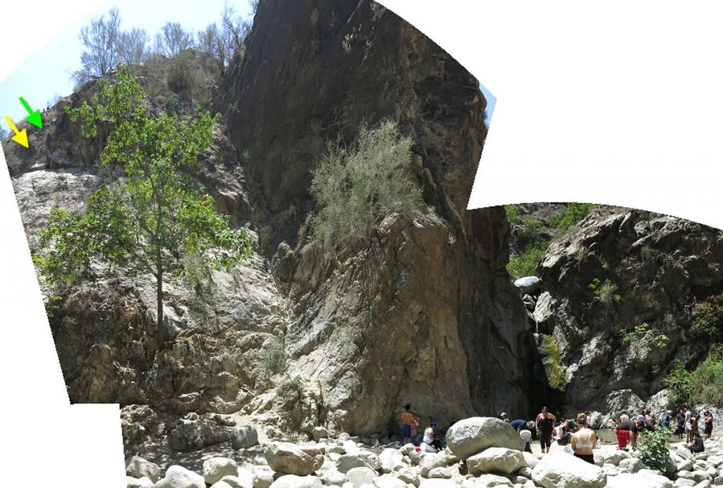
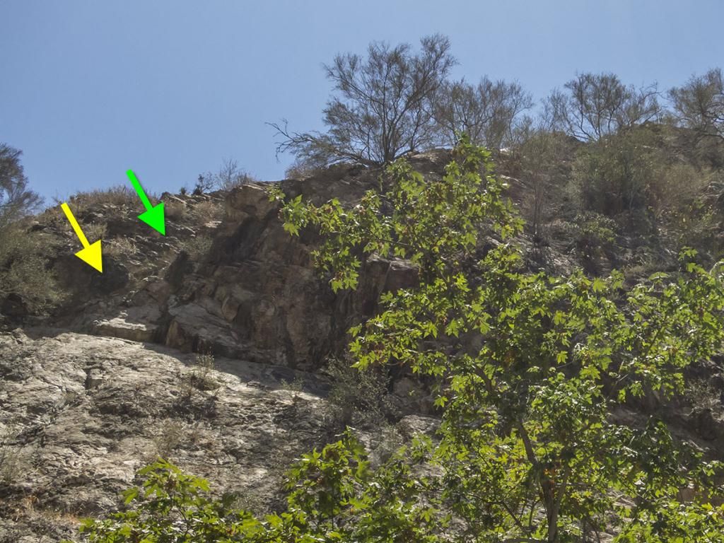
Thanks outwhere for the link to the full video. The girl fell from the north side of the Razorback. Apparently this happened late in the day, so my guess is they were on the way back and coming back down. I don't know why they were so far below the ridge. Either one of them fell earlier and ended up on the side of the cliff or they forgot the route back down and exited the ridge too soon, thinking (incorrectly) this was the way down.
In my pictures below, the girl was at the yellow arrow location and the guy was at the green arrow. The main gully in the middle is where people end up when they fall from the crux on the route. The other place they fall is from the south side of the ridge, usually because they mistakenly exit the ridge that way. There is another place they fall, but they'll end up in an area above the falls.
In my pictures below, the girl was at the yellow arrow location and the guy was at the green arrow. The main gully in the middle is where people end up when they fall from the crux on the route. The other place they fall is from the south side of the ridge, usually because they mistakenly exit the ridge that way. There is another place they fall, but they'll end up in an area above the falls.
Tim
Now it makes sense. I thought they were coming down almost where the water falls.
Are you old enough to have gone up the stairs? I did razor back once at 13, and the stairs twice a little older. I don't know how I made it this old. Thank god large sodas in New York and school brownies are against the law in schools now. Now THAT is dangerous!!!!
Interesting photo....imagine Razorback trail like this.
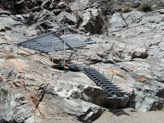 Bridge to Nowhere Hike by simonov, on Flickr
Bridge to Nowhere Hike by simonov, on Flickr
That's at the Bridge to Nowhere. It's just above the northern end of the bridge. There is a corresponding structure way down in the canyon just above the water, with an eyebolt in the rock wall.
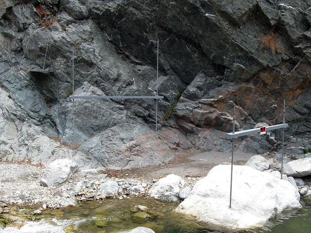
My theory is the Bungee America people are going to put in a zipline. Bad news is that might force them to close off some of the pools that will be under the zipline. Good news is they will be obliged to improve the trail beyond the bridge so zipline customers can safely climb back up.
Nunc est bibendum
Yes,,,, thanks Tim for sorting that out...
Aside from waking up and finding myself trapped at a Phish concert, finding myself in the lovely spot these two PUT themselves is right up there on the Razorback, well they were almost on top of the Razorback...
-
whatmeworry
- Posts: 57
- Joined: Tue Mar 03, 2009 1:28 pm
People have often gotten confused by the small drainages that drop off the ridge on both sides. Dropping over the side early leads into this particular area.
In my experience, people tend to be very narrow in their focus when they are in these kinds of areas. They aren't seeing the bigger view because they are focused on the 2 foot area around their hands and feet. I'm sure most of you have noticed that things often look very different when retracing a route.
Once someone commits to a course of action they often keep pressing forward in spite of conditions.
-
wheninROAM

- Posts: 9
- Joined: Sun Aug 17, 2014 6:46 pm
Im usually just lurking in the shadows around here but being an avid canyoneerer i thought other folks would appreciate the fs is allowing canyon travel again provided you follow thier requests... Not the best but at least its accessible to the right folks again....
http://www.fs.usda.gov/wps/portal/fsint ... road.shtml
Check out the current closures and map section on main page!
http://www.fs.usda.gov/wps/portal/fsint ... road.shtml
Check out the current closures and map section on main page!
-
Slowest_Hiker
- Posts: 245
- Joined: Sun Jul 31, 2011 12:31 pm
Maybe this is common knowledge, but I missed the memo. There are signs at both ends indicating the bridle trail ("Walnut Canyon?") is closed due to rain damage. We saw 2 people in orange vests up on it, so perhaps some trail work is going on.

The Idlehour Trail now has a very bad section just north of Idlehour Camp. A narrow piece of tread washed away in the recent storm, leaving little more than a muddy cliff. I kicked small footholds into the cliffside in order to cross the dangerous spot. The fall would be approximately fifteen or twenty feet into brush and rock. Be careful until someone can get back there with tools and create new tread.
I used a rock to improve the bad section. There is now a strip of level tread across the washout, the narrowest spot being six or seven inches wide. When I get actual tools back there, I can make it better.
There are a couple more trees down on the Idlehour. A big, messy one (north of the campground) required a bypass through poison oak. Once the weather clears, I'll go in with a saw and try to make it less of a mess. By my count there are now four or five large trees across the trail.
The Idlehour is being improved, I'm told by the Lowelifes. They are knocking back the heavier brush, removing downed trees, and doing treadwork. The spring growth, however, has light vegetation covering sections along the creek. I plan to attack it soon with my machete.
(Path overgrown with grass and plants.)
(New rock retaining wall)
(Path overgrown with grass and plants.)
(New rock retaining wall)
I've started repairing the bad spot on the Idlehour. This is the washed out section near the campground.
The plan is to stabilize the slope with a multi-tiered, dry rock retaining wall, then use the top tier to widen the trail tread.
Over the weekend I finished the bottom tier and started on the second one.
Hopefully I can return and complete the project before another one of those atmospheric rivers comes our way.