
VIDEOS - Post or link to videos!
I've never seen people work that fast - they get shit done 

I always think it's important to say "Thanks" everytime I see them working in the wilderness, they have a dedication and enthusiasm without compare - very hard work, good job I say and thanks for all you do.
I always think it's important to say "Thanks" everytime I see them working in the wilderness, they have a dedication and enthusiasm without compare - very hard work, good job I say and thanks for all you do.


A little about Tomaz: http://en.wikipedia.org/wiki/Toma%C5%BE_Humar
The majority of the video shows him climbing Reticent Wall on El Cap, which is a hard line. Really good stuff. Those moments are what life is all about. Very beautiful.
Here's the vid:
Cheers folks
The majority of the video shows him climbing Reticent Wall on El Cap, which is a hard line. Really good stuff. Those moments are what life is all about. Very beautiful.
Here's the vid:
Cheers folks
-
HikingGeek.com
- Posts: 126
- Joined: Thu Jan 01, 2015 6:15 pm
My first two attempts at making a long time lapse video. Hopefully they get better:
http://www.hikinggeek.com/2015/12/03/hi ... r-21-2015/
San Jacinto and SGW Time Lapse vids
http://www.hikinggeek.com/2015/12/03/hi ... r-21-2015/
San Jacinto and SGW Time Lapse vids

In light of the recent accidents on Mt. Baldy, here is a video of a husband and wife who tried glissading off Mt. Whitney. The snow had frozen over in the shade and the lady took a 750 foot fall. Luckily, she survived.
http://www.rockandice.com/weekend-whipp ... gone-wrong
http://www.rockandice.com/weekend-whipp ... gone-wrong
-
Huff and Puff
- Posts: 35
- Joined: Sun Feb 07, 2016 1:33 pm
She had an ice axe yet she could not self-arrest since she was out-of-control. When you are in that situation you are hosed. It is easy to loose control on a steep slope.
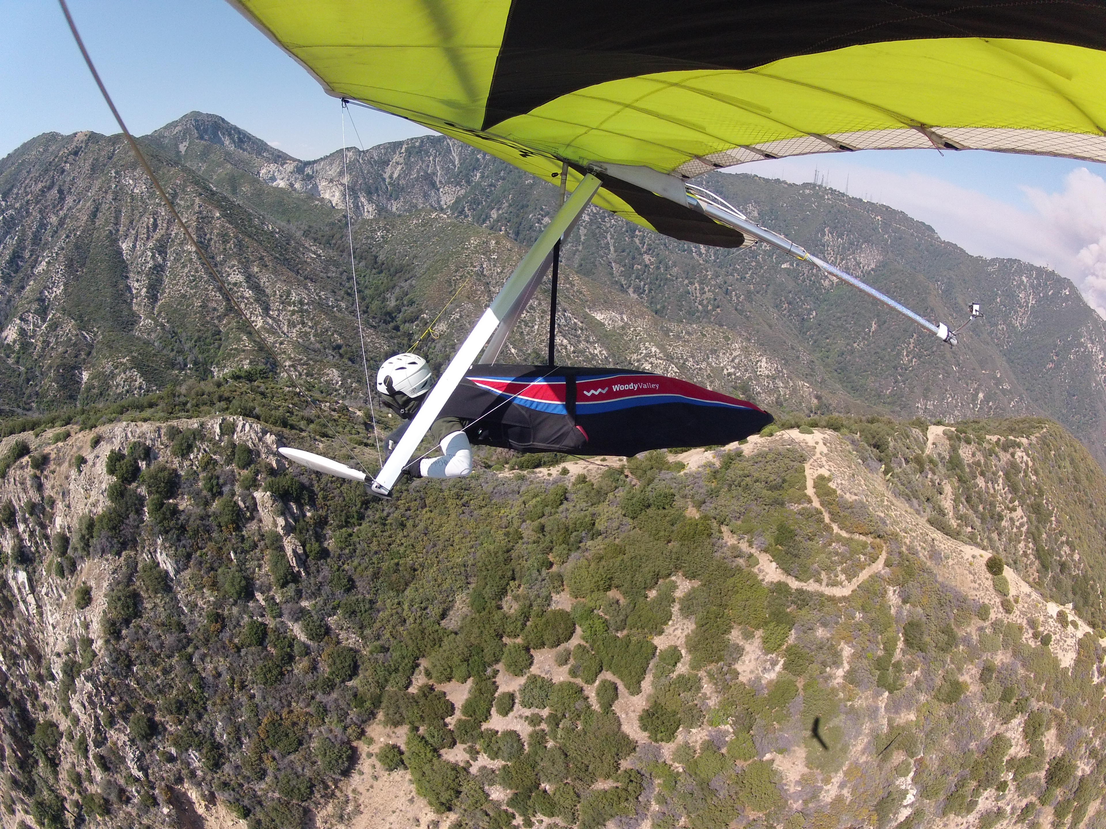
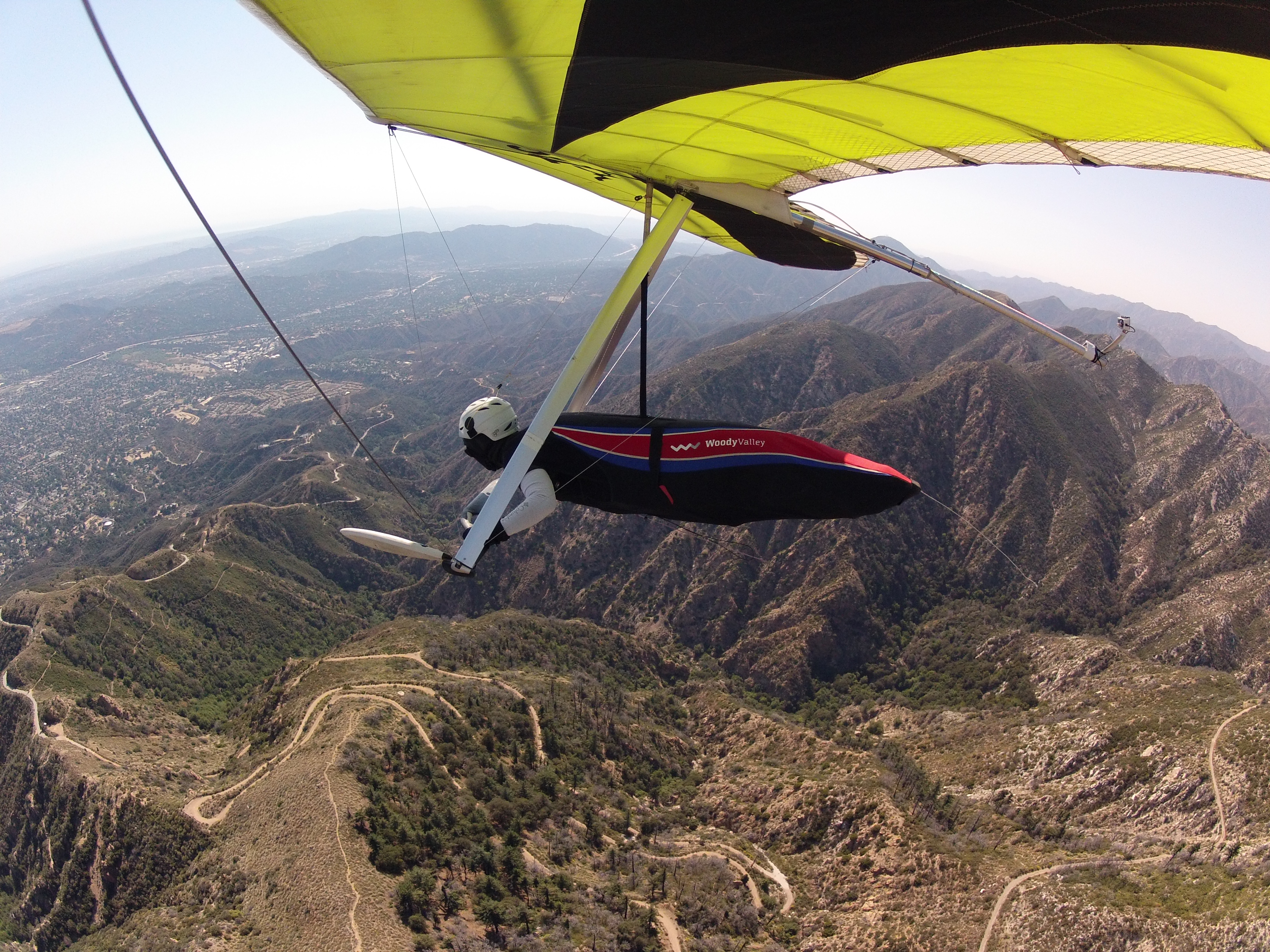
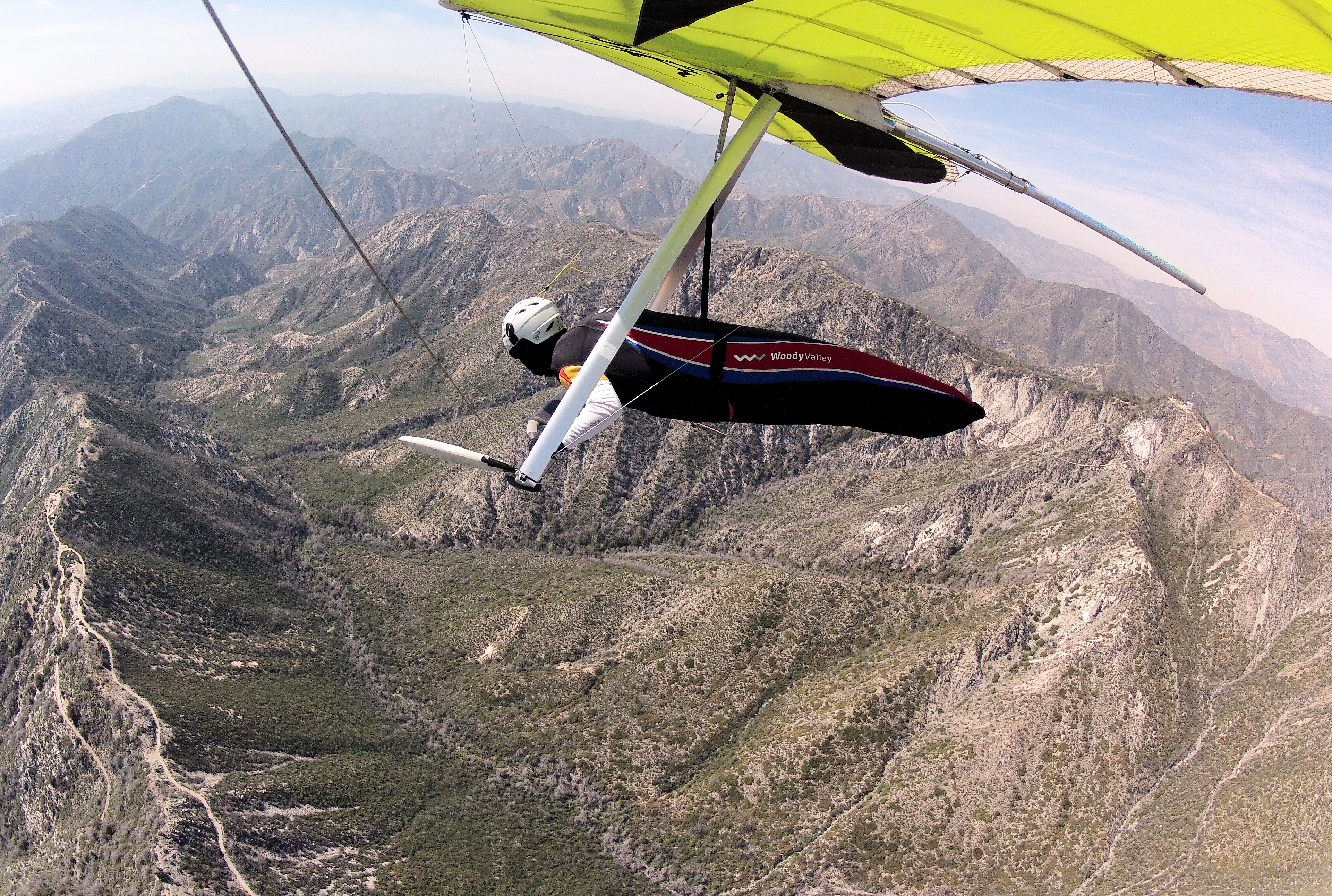
I used to hike the trails above Altadena through Monrovia during the late 80's but stopped decades ago. Over the past 7 years I have traversed the San Gabriel range the best I can via hang glider. On Monday I accomplished my lowest run ever between Brown Mountain and Muir Peak during the early stages of the San Gabriel Complex fire which appears in the background of my flight video.
I venture fairly close to a number of A number of popular trails and for anyone curious how this looks from an aerial vantage point I have edited this short video:
Cheers,
Jonathan
I venture fairly close to a number of A number of popular trails and for anyone curious how this looks from an aerial vantage point I have edited this short video:
Cheers,
Jonathan
-
Uncle Rico

- Posts: 1386
- Joined: Thu Mar 20, 2008 7:48 pm
I have no idea what you just said on the video but it was cool. 8)


I said a bunch of glider gibberish.Uncle Rico wrote: ↑I have no idea what you just said on the video but it was cool. 8)
I combed through your blog photos and lost count of the places I've flown over and past but have forgotten idea how great the views are from the trails. I have not hiked or mountain-biked since 1989.
Thanks. Although I have landed in some relatively small places, hang gliders generally need a lot of open space to land safely. OTOH - Paragliders can land in extremely tight areas and are an excellent means of soaring along mountain ranges, landing on top, camping overnight, then re-launching the following day and continuing on. This is known as Vol-Biv which is short for Free-flight Bivouac.
The technique was started in the 80's along both the Sierra Nevada and the Swiss Alps, IIFC at a time when paragliders were not well developed. Over the past decade or so, the rate at which paragliders have been used to traverse large mountain ranges has grown exponentially. I plan to add paragliding to my quiver for its many advantages. The hiking aspect will remain out of my reach.
Dave Turner has an excellent blog on vol-biv paragliding: http://sierraparagliding.com/what-is-xc ... iv-flying/
I suggest reading about his recent vol-biv trips: http://sierraparagliding.com/trip-repor ... dventures/
There are many excellent paragliding instructors/schools from Santa Barbara to San Bernardino. There are only a handful of hang gliding schools/instructors. It's a declining sport while paragliding is a growing sport. I started hang gilding in 1973 when I was 15 (Chicago area) and quit in 1982 then resumed in Los Angeles in 2008 and very quickly glommed on to as many local X/C (cross-country) pilots as I could in order to learn the ropes. Since that time at least half have dropped out of the sport. We are an aging population. Also, since that time X/C paragliding has been growing non-stop.
I am a dinosaur and one of the few remaining hang glider pilots willing to go long distances at low altitudes. I have had to call 911 for minor assistance on a few occasions and used my PLB one time for assistance getting out of the Santa Ana riverbed behind Seven Oaks Dam before I was caught in the dark. I carry a limited supply of emergency equipment in order to survive going down in remote areas. It's not much different than any other remote area activity--especially when going solo.
Getting back to your questions--if you want to combine mountain climbing/traversing with soaring then take up paragliding. If you want to fly across the mountains faster and in the prone position (like Superman) then learn hang gliding. I think it's best to learn both if you have the time and funds.
I suggest you take a tandem flight on a paraglider and on a hang glider and see what each is like. Feel free to message me and I'll try to suggest some places. This is our national organization resource locator: https://www.ushpa.org/page/find-a-school-or-instructor
Cheers, Jonathan
What a difference from the flights back in the early seventies. I used to live at San Gabriel Dam and pilots would jump off the Glendora Mountain road, fly along a ridge that runs into the dam, then land in the river bed below. It was actually the lake bed of Morris Dam reservoir and a no entry area. We were so fascinated by the flights we would pick them up, scould them (wink wink) and drive them up our entrance road to Hwy 38.GlideLA wrote: ↑My pleasure Gene!
I created this YouTube playlist of my longer flights. Many of these pass by hiking trails and peaks although I don't normally point these out.
Cheers,
Jonathan
They would catch a few thermals as the up canyon breeze hit the ridge, but the flights were relatively short. Eventually they managed flights to the mouth of the canyon landing near Azusa.
Have you considered a Camelback for hydration during long flights?
I have the bed of the Morris Dam reservoir in my waypoints as a potential bailout in case I don't get across from Pine Mountain to Glendora Mountain. Lately I found it works better to stay out front.Gene wrote: ↑....What a difference from the flights back in the early seventies. I used to live at San Gabriel Dam and pilots would jump off the Glendora Mountain road, fly along a ridge that runs into the dam, then land in the river bed below. It was actually the lake bed of Morris Dam reservoir and a no entry area. We were so fascinated by the flights we would pick them up, scould them (wink wink) and drive them up our entrance road to Hwy 38.
They would catch a few thermals as the up canyon breeze hit the ridge, but the flights were relatively short. Eventually they managed flights to the mouth of the canyon landing near Azusa.
Have you considered a Camelback for hydration during long flights?
Having started in 1973 and been following the sport for some time before that, it truly is amazing how far things have progressed but sad that there ar so few of us left. Every now and then I will land out somewhere and meet someone who was around in the early days and watched the shorts sled rides down the mountain from their home. Then I tell them where I took off and they react with amazement.
A few years ago I launched from Sylmar and landed in the soccer field in Claremont off of Padua Ave. The thermal coming from Potato Mtn just didn't have enough lift to get me across Mt Baldy Rd. One of the girls soccer coaches introduced himself and told me how he worked for Pacific Airwave Hang Gliders during the 80s while he was in high school. He had never seen anyone come in to land from flying a long distance. That was pretty cool.
On a flight from Mt Laguna to Whitewater I was talking 2-meter to a hiker who was standing on the summit of Mt San Gorgonio and waiting for his friend in a sailplane to fly by. I tried my best to get across the Banning Pass with enough altitude but it was all blown out which made from an interesting landing.
Yes, we do fly with hydration packs. I avoid drinking water during flight or I'll have to pee. Some pilots wear external catheters and run a vinyl tube down one pant leg then just unzip their harness and dangle that leg.

Very wild and crazy! I've always wondered how beginners practice before taking their first flight. It seems like you are allowed to make many mistakes during a flight or it would be your last flight. I helped some guy get his cables hooked up above Lake Elsinore a couple of years ago. It all looked quite technical.
Thanks for sharing this video. It is a completely different world.
Thanks for sharing this video. It is a completely different world.
Modern instruction consists of tandem mountain flights and solo bunny hill flights. The tandem method works great so novice pilots get to learn how to steer the glider and how the air works right away. Then they learn to launch and land by themselves without ever being more than a few feet off the ground. It's a very gradual and progressive system that advances based on the individual pilot. Not like the early days when I first learned.tekewin wrote: ↑Very wild and crazy! I've always wondered how beginners practice before taking their first flight. It seems like you are allowed to make many mistakes during a flight or it would be your last flight. I helped some guy get his cables hooked up above Lake Elsinore a couple of years ago. It all looked quite technical.
Thanks for sharing this video. It is a completely different world.
-
Uncle Rico
- Posts: 1386
- Joined: Thu Mar 20, 2008 7:48 pm

Thanks. And thanks again to you and everyone else who does trail maintenance. Does this scene show the West Fuji and the Lone Tree Trail?
 click for full-size
I'm doing file maintenance for a project and put up a small album of trail images: http://imageevent.com/aero92/sangabrieltrails
I am especially happy with this capture.

Looks like the east ridge of Muir, elevation 4600, looking north. That one was bullodozed from the Station Fire. West Fuji is SW of that, at elev 3600.
The trail continues SW...down to Rubio canyon area-ish.
I suspect the second photo is the 'Grand Canyon'.
Cool trip!
Here's perhaps my best shot of Grand Canyon.
Is this trail on the left one of yours?

In the video, between 5:45-6:00 minutes you are heading straight for the ridge between Panorama Point (upper left) and the West Fuji plateau (lower right). The upper Lone Tree Trail used to go up that Ridge. Now it's an old firebreak with a use path and portions of the old trail still intact. And if you look closely you can see the lower trail, which is maintained, descending West Fuji from the rock outcropping in the middle of the plateau and contouring around the west slope.