
I noted in reading Neil Armstrong's obituaries last year that during the time he worked out of Edwards Air Force base, he lived in a cabin in the San Gabriels. It was variously described as "a small shack without indoor plumbing" or "an old ranger's cabin."
http://www.latimes.com/news/obituaries/ ... full.story
I've wondered since where it was. Anyone know anything of it? Answer generally or in private if vandalism is a concern.
I am thinking that the area around Hidden Springs would be reasonable for commuting in for Edwards, but that's just a guess.
History question: Neil Armstrong's cabin in the SGs
little bit more info:
http://annapuna.blogspot.com/2012/08/ne ... trong.html
http://annapuna.blogspot.com/2012/08/ne ... trong.html
Then it was off to Edwards AFB and being a test pilot where he flew the X-15. He spent seven years at Edwards. He and his wife Janet restored an old ranger's cabin in the foothills of the San Gabriel Mountains to raise their three children.

From the internet:He was a resident of Juniper Hills just before ANF territory. Not sure how far the Station Fire burned over there.
Call me cynical, but I think Juniper Hills would be making money off the cabin/him if it still existed. I noticed Palmdale kind of trying to get their share of the loot by making loose claims to his legacy....but it belongs to Juniper Hills.
Contrast that to today's govt...
http://www.laweekly.com/2011-06-23/news ... perty-war/

-
Slowest_Hiker
- Posts: 245
- Joined: Sun Jul 31, 2011 12:31 pm
Good info! Lots of hits on Juniper Hills. Thanks!
Hey there. Wondered if you ever found out Neil Armstrong's cabin location? We just watched First Man, and having property near Devils Punchbowl State Park, we were curious. Have done many hikes around that area. Haven't found anything more online......
-
Slowest_Hiker
- Posts: 245
- Joined: Sun Jul 31, 2011 12:31 pm
No, I never uncovered anything more specific than Juniper Hills. The google trail did have some interesting reading though. Apparently his wife taught practically every kid in Juniper Hills how to swim. Someone had a scan of his completion certificate signed by her.
good luck, if you "search Google for this image" there are some more shots. It's close to the foothills. Also on some First Man trivia site I saw a reference to how some old guy claimed to live in Armstrong's old cabin and let the movie crew take reference shots inside
-
Slowest_Hiker
- Posts: 245
- Joined: Sun Jul 31, 2011 12:31 pm
Awesome! Every once in a while, a colleague gets transferred to Palmdale and has to decide where to live. I always tell them Neil Armstrong figured that out decades ago. (I'd pop for indoor plumbing myself though).

-
electric_park
- Posts: 7
- Joined: Mon Feb 20, 2023 1:16 pm
To everyone in this thread, sorry it's so late, but I just discovered this site. I do believe I figured out where the cabin is/was several years ago.
The official address that Neil filled out for his NASA application to the space program was:
29234 106th St E
,Littlerock, CA
This fits with him having the cabin in Juniper Hills, but I also think there is more evidence to suggest this is it, or just adjacent to it.
If you search in Google Maps for that address you will be taken here:
Google Maps to Cabin
Now if you try to drag the little "yellow man" from the Google Maps UI, you will notice that you can't go onto that exact dirt road, but you can place your streetview location just below that property on the main road(Juniper Hills Rd):
The view will look something like this:
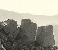
And if you zoom in a bit to that hill off in the distance to the right:
Then I'd say it's exactly that hill in the background of the photo of the cabin above in this thread.
If you also consider that you view would actually be from a much higher vantage point up that dirt road and above the cabin a bit(the vantage point of the earlier photo of the cabin) then I'd say it's pretty much almost exactly this location.
What say all of you?
The official address that Neil filled out for his NASA application to the space program was:
29234 106th St E
,Littlerock, CA
This fits with him having the cabin in Juniper Hills, but I also think there is more evidence to suggest this is it, or just adjacent to it.
If you search in Google Maps for that address you will be taken here:
Google Maps to Cabin
Now if you try to drag the little "yellow man" from the Google Maps UI, you will notice that you can't go onto that exact dirt road, but you can place your streetview location just below that property on the main road(Juniper Hills Rd):
The view will look something like this:
And if you zoom in a bit to that hill off in the distance to the right:
Then I'd say it's exactly that hill in the background of the photo of the cabin above in this thread.
If you also consider that you view would actually be from a much higher vantage point up that dirt road and above the cabin a bit(the vantage point of the earlier photo of the cabin) then I'd say it's pretty much almost exactly this location.
What say all of you?

Yeah, it's clearly there-ish. Render from today: https://caltopo.com/view#ll=34.4351,-11 ... 6.36,50.41
The hill is at the center of the render. The darker thing above it in the original photo is "Black butte". The lighter stuff to the right of that is the "Three sisters". Zoom onto the render to see it.
The assessor seems to think the original buildings were built in 1935 (effectively in 1955), so that could be it: https://portal.assessor.lacounty.gov/pa ... 3059025033
The photos on the assessor's page don't look like the building in the photo, so it's probably gone. We can also see that some structures burned down in the bobcat fire (zooming in moves the photo date from 2020 to 2022, and we can see that some buildings are gone). Maye it burned sometime too
-
electric_park
- Posts: 7
- Joined: Mon Feb 20, 2023 1:16 pm
I do know that I read somewhere that his cabin was built in 1935, but I can't recall where.
Actually maybe the building is still there. Is it this one from the assessor's photos:
It's facing the correct direction and has the chimney in the right spot. Obviously, if this is the building, there have been a number of additions built over the years, but maybe!
It's facing the correct direction and has the chimney in the right spot. Obviously, if this is the building, there have been a number of additions built over the years, but maybe!
-
electric_park
- Posts: 7
- Joined: Mon Feb 20, 2023 1:16 pm
That's what I was thinking, is that the original roofline is there and it's been added on to. All right...road trip!!!
I am not from this area or California at all. But what sort of people live out here in this half wilderness?
I am not from this area or California at all. But what sort of people live out here in this half wilderness?
The power lines are in the right spot too. This is probably it. If you're interested, look through the old aerial imagery to see if the additions disappear as you go back in time: https://mil.library.ucsb.edu/ap_indexes/FrameFinder/
The resolution on those may or may not be high-enough to tell
The resolution on those may or may not be high-enough to tell
-
electric_park
- Posts: 7
- Joined: Mon Feb 20, 2023 1:16 pm
I half wonder if the people who live there now even know that it was Armstrong's old cabin?

-
electric_park
- Posts: 7
- Joined: Mon Feb 20, 2023 1:16 pm
-
electric_park
- Posts: 7
- Joined: Mon Feb 20, 2023 1:16 pm
What is that GIS type system you linked me to and how do you use it?dima wrote: ↑Yeah, it's clearly there-ish. Render from today: https://caltopo.com/view#ll=34.4351,-11 ... 6.36,50.41
The hill is at the center of the render. The darker thing above it in the original photo is "Black butte". The lighter stuff to the right of that is the "Three sisters". Zoom onto the render to see it.
The assessor seems to think the original buildings were built in 1935 (effectively in 1955), so that could be it: https://portal.assessor.lacounty.gov/pa ... 3059025033
The photos on the assessor's page don't look like the building in the photo, so it's probably gone. We can also see that some structures burned down in the bobcat fire (zooming in moves the photo date from 2020 to 2022, and we can see that some buildings are gone). Maye it burned sometime too
-
electric_park
- Posts: 7
- Joined: Mon Feb 20, 2023 1:16 pm
I updated my post from before (#14) because I realized my Google Maps link was broken.
The caltopo link? It's http://caltopo.com. Can (among other things) render terrains, which is what I linked to above.
I did look at the historic aerials of that house. The image quality is poor, but it looks like the structure wasn't at all there in the 1950s, and appeared with all the additions intact in the 1960s. If that's true (images aren't great, so maybe I'm just not seeing it right), then the building we thought was the original structure isn't it. But the renders are right, so it's very close to that spot.
I did look at the historic aerials of that house. The image quality is poor, but it looks like the structure wasn't at all there in the 1950s, and appeared with all the additions intact in the 1960s. If that's true (images aren't great, so maybe I'm just not seeing it right), then the building we thought was the original structure isn't it. But the renders are right, so it's very close to that spot.
I looked into this some time ago. The cabin is in aerials from 1952 and 1959. You have the correct location. I'm not sure what you're missing, Dima. The additions came some time after 1959. I could have more data but I'm cheap and won't pay for the other aerial imagery available.
The aerial images aren't amazing, and trees look very much like a house would. The little loop driveway road isn't clearly visible in 1952 and 1959 either, but again, it's not obvious to me. Do you know of a source of historical imagery that's better than this but costs $? I don't want to pay $ for this one either since I think we have the right spot, but I could be interested for other things.
No. I'm just using the free, UCSB library of aerial imagery. Do you see the blurry cabin footprints in the images I posted? From the hook road, look up and left, and compare those footprints to the original structure in the Google aerial with the current footprint.
I'd bet money that they do. It was probably a talking point when they bought the house.electric_park wrote: ↑I half wonder if the people who live there now even know that it was Armstrong's old cabin?