

Angeles Crest Repairs
I rode from Vincent Gap to Dawson saddle at the end of August and found the repairs nearly completed including all new asphalt. However there is a section half a mile from the gate that must have washed out during the heavy thunderstorms and there is only one lane left and what is left is undercut badly. Since this section is on a very steep slope of Baden Powell the repairs may take a while. ( like maybe summer of '08)
Jim
Angeles Crest Highway (CA-2)

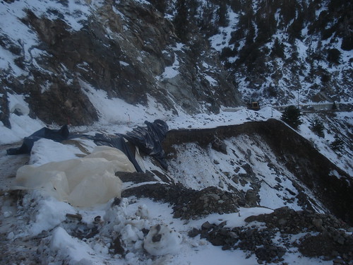
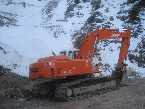
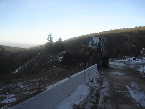
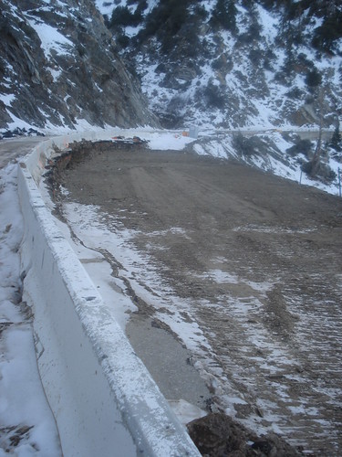
I took this picture on a ride of the closed ACH section on September 9. I posted a more complete report on another board (before this one got started).

-
luciano136
- Posts: 35
- Joined: Mon Oct 01, 2007 11:52 am
Hey folks,
Anybody been out there since the snow from last weekend? I wonder if there's any ice on the road orso? Will probably go for a quick jaunt up Waterman Sunday...
Thx!
Anybody been out there since the snow from last weekend? I wonder if there's any ice on the road orso? Will probably go for a quick jaunt up Waterman Sunday...
Thx!
We walked along the ACH from Dawson Saddle to Vincent Gap yesterday. The majority of the road has been repaved and there is working happening on 2 of the 3 washout sections. Hoever, the one MAJOR washout has no work going on and is going to need a bridge or something to fix. I am still positive and thinking that all this work means they are prepareing for opening this road in the not-so-distant future. Notice the last photo taken at a distance, the coulior above the major washout looks like it could be climbable with a little more snow and a few freeze/thaw cycles to get some ice (taco?)
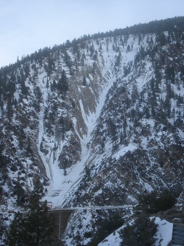

If that's the couloir leading up to near or direct the summit of Throop, I have it marked as "Driveby Couloir", and it looks good.
I feel they'll open ACH up fully relatively soon, since they've fixed a bunch up, and I've been stopped by construction near Kratka Ridge before.
I feel they'll open ACH up fully relatively soon, since they've fixed a bunch up, and I've been stopped by construction near Kratka Ridge before.
The straight on shot of that gully makes it look steeper than it is. The steepest part is just above the top of the gully and is 30-35 degrees.
This is a fine route in the spring when you can crampon up before the sun softens it and then ski down on fine corn snow after the sun does its job.
There are all kinds of fun chutes and gullys on the ridge between Powell and Throop.
I usually hit these in the spring when the road is clear of snow when I can use my mountain bike to access the routes further up the road.
I,ve climbed and skied the gullys coming off of the summits of Burnham and Throop but not the ridge between. It is steep but not much vertical.
Throop is interesting as it seems to catch more snow than the other peaks and hold on to it into summer some years.
A few years back I was able to ski top to bottom traversing a few dry spots in July!
It wasn't great skiing and the skis took a beating but it was fun to tell the story afterwards.
Throop is interesting as it seems to catch more snow than the other peaks and hold on to it into summer some years.
A few years back I was able to ski top to bottom traversing a few dry spots in July!
It wasn't great skiing and the skis took a beating but it was fun to tell the story afterwards.

TDR, I hope you're right, but from the photos posted here and on the Whitney boards, that major washout is just that: major. It's going to take a big project and lots of $$$'s to fix it. If you have seen any of the governator's proposals ... well, let's just say don't hold your breath. I sincerely hope I'm wrong (would reallly like to do that quick jaunt up Throop from Dawson saddle), but as the economy and therefore tax revenue goes into the tank, money for a non-priority hwy like ACH is unlikely to be forthcoming.TacoDelRio wrote: I feel they'll open ACH up fully relatively soon, since they've fixed a bunch up, and I've been stopped by construction near Kratka Ridge before.

I wonder if they are planning on opening up the ACH as far as Dawson Saddle instead of keeping the closure at Islip Saddle. They've done all the road improvements and Dawson (if I remember correctly) is a relatively large turnout area that would make for a good parking/turn around area. Are there existing gates at Dawson (like the ones at Islip)? Are there any existing gates elsewhere along that stretch of ACH?
Rte. 39 went out in the winter of 1969, which was a messy one. I was living in Azusa at the time and, in addition to what was going on in the Crystal Lake area, and there was a sea of mud covering much of Azusa Ave. and several other major streets. I lived in NY from 1974 - 1994 but heard from friends out here that 39 as briefly re-opened sometime in the late 1970s. Nature took care of that.TacoDelRio wrote:Yeah, I'm not betting on it, just hoping. Route 39 would be nice as well, but that' hasn't been touched much since what, 1968?
That would be great if they would reopen as far as Dawson Saddle. There is a turn out there near that big Cal Trans maintenance shed. It's not as good as at Islip, but I think it would work.
I have been kind of curious as to why they were spending so much time and money to fix up the closed part of the road. Opening it to Dawson would explain the expenditure.
I've read on forums that 39 is passable by bicycle and on foot.
I have been kind of curious as to why they were spending so much time and money to fix up the closed part of the road. Opening it to Dawson would explain the expenditure.
I've read on forums that 39 is passable by bicycle and on foot.
-
brian90620
- Posts: 123
- Joined: Sun Jan 27, 2008 8:34 pm
Hello everyone, I just wanted to let you guys know that the Angeles Crest highway is now open to the gate just beyond the Snowcrest ski area, just in case anyone was wondering  . The Caltrans road info webpage seems to be inaccurate since it says the road closure is 3.3 miles past Newcomb Ranch, I was there yesterday and was able to drive way past that.
-
Richard N.
- Posts: 91
- Joined: Tue Feb 12, 2008 9:47 pm
Don't get your hopes up to fast regarding repairs on ACH near Vincent Gap. Cal-Trans will be building a bridge across the slide area. Expect the road to be closed until late 2009 or early 2010.

-
cougarmagic

- Posts: 1409
- Joined: Wed May 07, 2008 5:21 pm
I wanted to hike Mt Waterman today - and got stopped by closed gates at that huge parking area, where the PCT crosses the road. I think it's Cloudburst Summit - it was past Newcomb's, and maybe 4 miles before Buckhorn. Anyone know what's up with that? My calls to the forest service offices are, as usual, less than enlightening: "Oh really? I don't know anything about that!" was what the supervisors office said. All the other offices just go to voicemail, and I know that will never get listened to...
Anyway, I want to know because I would like to try to hike there again tomorrow, but don't want to waste gas and time finding out! Anyone have a friend at the Angeles FS?
Anyway, I want to know because I would like to try to hike there again tomorrow, but don't want to waste gas and time finding out! Anyone have a friend at the Angeles FS?
-
JMunaretto
- Posts: 370
- Joined: Thu Feb 07, 2008 11:03 am
ummm I can contribute no information but I will be pissed off if it is closed this weekend.
The Caltrans site is usually good. It only lists the closure from Islip Saddle to Vincent Gap.