
Angeles Crest Highway (CA-2)

There might be a checkpoint after Switzer's. Lots of cars were parked at a big turnout and people were walking down the road. But when I arrived the road was cleared and no checkpoints. There is another storm coming. So if you're going up this weekend, you might need chains, especially if you start early when the road is still frozen.bapolis wrote: Sounds like a gamble? The Caltrans website has said that chains are required at around the AFH junction for a while. I assumed there were checkpoints.
-
Tom Kenney

- Posts: 351
- Joined: Sat Sep 29, 2007 7:51 pm
CA-2 was closed at Red Box today noon. Coincidentally, that was also the snowline...coming down fast and heavy.
Thanks for the report. I've also been checking these pages:Tom Kenney wrote: CA-2 was closed at Red Box today noon. Coincidentally, that was also the snowline...coming down fast and heavy.
http://www.dot.ca.gov/cgi-bin/roads.cgi
http://quickmap.dot.ca.gov
-
Slowest_Hiker
- Posts: 245
- Joined: Sun Jul 31, 2011 12:31 pm
I was up there yesterday. The 2 was closed between Red Box and Upper Big T. (Well, we didn't see the closure at Red Box with our own eyes, but that's what I understand). We had to go in from Sunland via Big T -> AFH -> Upper Big T -> ACH. Gate at Kratka was closed on the ACH. CA DOT has been putting out loads of misinformation. Newcomb's facebook is sadly a more reliable source. At the moment, based on what I saw yesterday, I think Caltrans District 7's twitter is correct, but it has been wrong in the last weeks too.
Oh yeah re: chains, all the signs saying chains required were up, but no one was checking. We saw cars that had no chains and were unlikely to have snow tires, but past Newcomb's, though, I would say chains or 4WD/AWD & snow tires were advisable.
Oh yeah re: chains, all the signs saying chains required were up, but no one was checking. We saw cars that had no chains and were unlikely to have snow tires, but past Newcomb's, though, I would say chains or 4WD/AWD & snow tires were advisable.
Good to know. Maybe calling Caltrans is the way to go?Slowest_Hiker wrote: I was up there yesterday. The 2 was closed between Red Box and Upper Big T. (Well, we didn't see the closure at Red Box with our own eyes, but that's what I understand). We had to go in from Sunland via Big T -> AFH -> Upper Big T -> ACH. Gate at Kratka was closed on the ACH. CA DOT has been putting out loads of misinformation. Newcomb's facebook is sadly a more reliable source. At the moment, based on what I saw yesterday, I think Caltrans District 7's twitter is correct, but it has been wrong in the last weeks too.
Oh yeah re: chains, all the signs saying chains required were up, but no one was checking. We saw cars that had no chains and were unlikely to have snow tires, but past Newcomb's, though, I would say chains or 4WD/AWD & snow tires were advisable.
What about LA County's website? I've been checking their road closures page too: https://dpw.lacounty.gov/roadclosures/
-
Slowest_Hiker
- Posts: 245
- Joined: Sun Jul 31, 2011 12:31 pm
LA county seems to have been generally pretty good, but I'm not sure at all why they've been reporting on Hwy 39 at all, as I thought that was Caltrans' domain, and they've contradicted Caltrans there, so I'm not sure whom to trust.
If current eyewitness reports like Newcomb's or Crystal Lake Cafe are available, I definitely let those override contradictory info from Caltrans. Probably County too, if there's not an obvious reason for disagreement.
If current eyewitness reports like Newcomb's or Crystal Lake Cafe are available, I definitely let those override contradictory info from Caltrans. Probably County too, if there's not an obvious reason for disagreement.
You were right. I checked Caltrans' QuickMap yesterday before heading out and it showed that the 2 was closed eastbound at Shortcut Picnic Area (it still shows that). However, the eastbound was actually open at that point. I'm not sure how far though; I parked at Shortcut.Slowest_Hiker wrote: LA county seems to have been generally pretty good, but I'm not sure at all why they've been reporting on Hwy 39 at all, as I thought that was Caltrans' domain, and they've contradicted Caltrans there, so I'm not sure whom to trust.
If current eyewitness reports like Newcomb's or Crystal Lake Cafe are available, I definitely let those override contradictory info from Caltrans. Probably County too, if there's not an obvious reason for disagreement.
-
Tom Kenney
- Posts: 351
- Joined: Sat Sep 29, 2007 7:51 pm
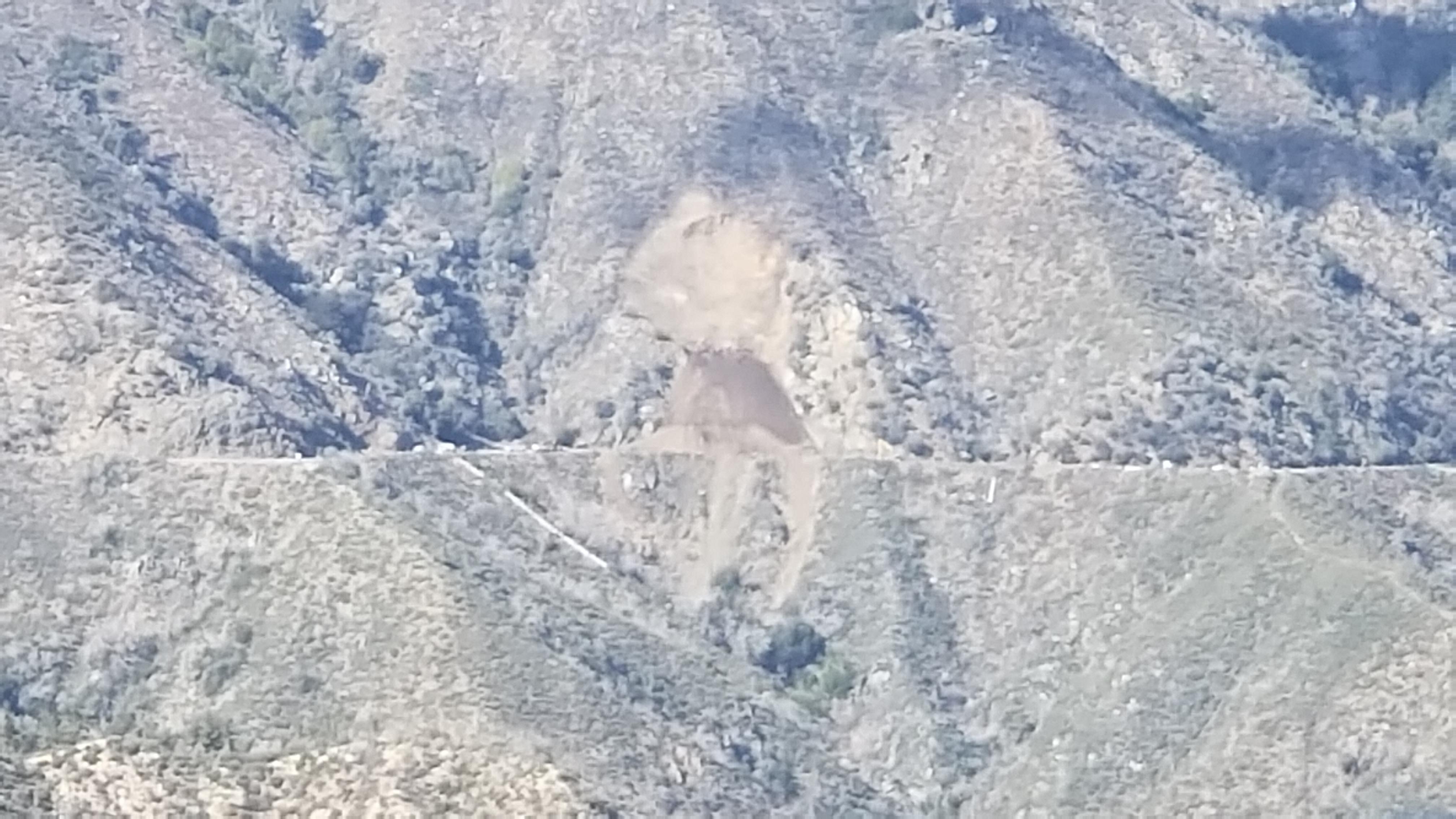
CA-2 is currently closed between Red Box and Barley Flat Road. Reason: approximately 100mH X 150mW of mountainside decided to lurch closer to the beach. The whole roadbed had been covered, but a single truck-width has been cleared. There are 2 excavators parked nearby, but (...risks sounding corny...) they're gonna need a bigger boat.
-
Tom Kenney
- Posts: 351
- Joined: Sat Sep 29, 2007 7:51 pm
Here's an interesting vid re slide cleanup (h/t to u/BlankVerse for posting at reddit on r/AngelesNationalForest): CalTrans Spyder

It is seldom seen because the road is typically closed, but there have been slides below the canyon road such that the road just ends in a drop off and a shear rock face. In those cases a bulldozer operator drives over the edge and "surfs" the nearly verticle slide to the bottom, sometime more than 600 feet down. Yes, in case you're wondering, some of those operator's anatomy is solid brass. Once at the bottom of the slide they get a flat cut into the slide and back up to the up canyon side as far as possible. Then ten wheel dump trucks back to the edge of the road and dump a load of rocks and dirt. After that the bulldozer operator packs the dirt and rocks into the flat he and again moves up canyon for the next load. This continues until the dozer is level with the existing road bed. They lay down some asphalt and move to the next slide. I have watched this process from the top of San Gabriel dam many times and often the bulldozer almost reached the lake water on the initial plunge. In 1969 there were some many slides it the road closed for nearly a year.
-
VermillionPearlGirl
- Posts: 239
- Joined: Wed Apr 06, 2011 9:57 am
And the 2 is still closed after Red Box right? Can you take Big Tujunga Canyon road and drop in above it?
-
Sammsquatch
- Posts: 4
- Joined: Fri May 04, 2018 10:46 pm
That is an affirmative VermillionPearlGirl.VermillionPearlGirl wrote: And the 2 is still closed after Red Box right? Can you take Big Tujunga Canyon road and drop in above it?
-
VermillionPearlGirl
- Posts: 239
- Joined: Wed Apr 06, 2011 9:57 am
It's funny I was at the Baldy Ranger station last weekend, they called a different station and they said the 2 was open except at Vincent Gap. But Caltrans still says it's closed 14 miles north of La Canada. It's so hard to get info!
So, I tried to find some contact info to complain, in hopes that they would rectify the situation. That didn't do any good, but I did get a phone number to a district office which will hopefully be able to give out correct information. The number is (909) 383-4631. I'm going to call that number before I try to go up from the East again.

There used to be a Wrightwood discussion forum that usually had a local providing up to date info on the 2. There also used to be a few motorcycle firums that posted the latest (including the usual weekend carnage). I am way way way too lazy to look for them though.
This page seems to provide accurate and up-to-date info: https://www.facebook.com/AngelesCrestHighway/
Here is a recent article on the landslide repairs. It includes lots of pictures and some videos. The writing is good too. I like this line: "Looming 10,000 feet over Los Angeles like an unsteady drunk uncle, the San Gabriels are among the fastest-growing and fastest-eroding mountains in the world, vomiting loose rock with prodigious enthusiasm."
Now that's a sentence. And it seems fairly accurate, too.Sean wrote: Here is a recent article on the landslide repairs. It includes lots of pictures and some videos. The writing is good too. I like this line: "Looming 10,000 feet over Los Angeles like an unsteady drunk uncle, the San Gabriels are among the fastest-growing and fastest-eroding mountains in the world, vomiting loose rock with prodigious enthusiasm."


My guess is that dumping that much material over the side would kill a lot of vegetation and make the headwall even more unstable. Normally it would have more evenly washed downslope, but the road held it up.dima wrote: Thanks for that article. I was previously assuming that the dirt would simply be pushed over the edge into the canyon below, but I guess they're trucking it out instead.
Can confirm that ACH is open on the East side from Vincent Gap to Islip Saddle. (for now) Drove up there on Monday afternoon to check on conditions, and ended up giving a few PCTers rides. Lots of small rock fall on the road, especially between Vincent Gap and Islip Saddle, with some larger rocks in some places.
-
VermillionPearlGirl
- Posts: 239
- Joined: Wed Apr 06, 2011 9:57 am
When I was still confused a couple weeks ago I ended up tweeting CalTrans and shockingly that worked. They responded quickly with correct information 
But yay if Vincent Gap is open for Memorial Day weekend
But yay if Vincent Gap is open for Memorial Day weekend