
I'm Twitter illiterate, so how did you contact them? I put Twitter on my phone so I can get better road conditions info. Thanks!VermillionPearlGirl wrote: When I was still confused a couple weeks ago I ended up tweeting CalTrans and shockingly that worked. They responded quickly with correct information
But yay if Vincent Gap is open for Memorial Day weekend
Angeles Crest Highway (CA-2)
-
VermillionPearlGirl
- Posts: 239
- Joined: Wed Apr 06, 2011 9:57 am
I just replied to their tweet about the road being closed --
-
Slowest_Hiker
- Posts: 245
- Joined: Sun Jul 31, 2011 12:31 pm
We drove the entire length La Cañada to Wrightwood today. They had reportedly re-closed Islip Saddle to Vincent Gap yesterday for the storm, but re-opened it this morning. Rocks were fairly numerous after Buckhorn or so.
-
Tom Kenney

- Posts: 351
- Joined: Sat Sep 29, 2007 7:51 pm
I think CA-2 may be opened at Red Box->Shortcut in the next few days. Most of the blockade at Red Box has been removed.
-
CrazyHermit

- Posts: 343
- Joined: Mon Sep 07, 2015 1:03 pm
Amazing footage of the slide and how they're fixing it. They have to go from the top down.
The road from Redbox up will be closed until November, but there is a long detour via Angeles Forest Hwy and Big Tujunga Road available to get around it.
Check out the SPIDER vehicle they put up at the top of the slide.
The road from Redbox up will be closed until November, but there is a long detour via Angeles Forest Hwy and Big Tujunga Road available to get around it.
Check out the SPIDER vehicle they put up at the top of the slide.
-
Tom Kenney
- Posts: 351
- Joined: Sat Sep 29, 2007 7:51 pm
A certain impediment to travel between Red Box and Shortcut has been removed...wink wink, nudge nudge, say no more!
-
Tom Kenney
- Posts: 351
- Joined: Sat Sep 29, 2007 7:51 pm
I had occasion to be at Grassy Hollow on Saturday (2020-04-25). It appears that CA-2 is closed at (and west of) Big Pines/N4 junction. I say 'appears' because I didn't actually go to the N4, but there was no traffic at Grassy Hollow, stragglers hiking the road mid-lane, and Inspiration Point was empty. On the previous weekend, crowded, so this was a 'crowd busting' tactic?
If you're a skier, plenty of beautiful corn is still to be had on Baden-Powell, but you'll have to hike up Big Rock Creek or hoof the 16km/10mi on CA-2. Somebody thought this a good trade, since there are ski/board tracks in some of the chutes.
Also, some elves told me that Dawson Saddle is not yet clear...

-
Tom Kenney
- Posts: 351
- Joined: Sat Sep 29, 2007 7:51 pm
CA-2 is open at Islip. I had to make an interesting call into CHP last night. Apparently CalTrans sent 'the new guy' to unlock the CA-2 gate at Islip. That person also opened the CA-39 gate. It was open all day yesterday, and folks were merrily driving down...and back up, since the lower gate is still closed.
Haha. That's amazing.Tom Kenney wrote: ↑CA-2 is open at Islip. I had to make an interesting call into CHP last night. Apparently CalTrans sent 'the new guy' to unlock the CA-2 gate at Islip. That person also opened the CA-39 gate. It was open all day yesterday, and folks were merrily driving down...and back up, since the lower gate is still closed.
-
Tom Kenney
- Posts: 351
- Joined: Sat Sep 29, 2007 7:51 pm
Overnight parking has been fine, just not in any closed lots (there are still a few). To 'demonstrate,' lots of my riding is at night, so I'm frequently returning to my quite late. This has been my experience on CA-2. Not sure about Chantry or any of the others. Curfew seems to mainly be about city. Also, very selectively enforced? I returned home last night after midnight, passed at least 2 patrols, didn't seem interested in me or any of the other drivers out at that time.


-
Tom Kenney
- Posts: 351
- Joined: Sat Sep 29, 2007 7:51 pm
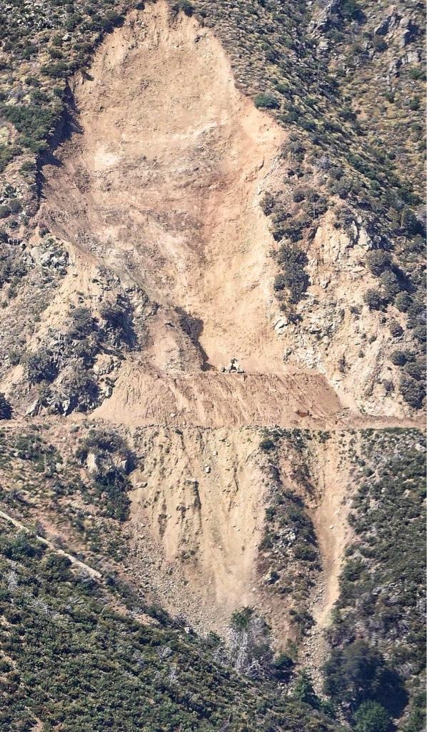
After having a look from a distance (Wilson Rd), it is my un-expert opinion that Lawlor-Barley Flats segment of CA-2 is doomed.
The huge slide on Lawlor that was repaired recently has re-slid and consumed the road again. It is unclear if the road and debris wall have left the site, or if they are simply buried. To complicate, the lush spring that caused all the trouble is clearly visible as a huge wet spot on the slope above the highway, dead-center in the slide path. Another wet spot is visible below. This says to me the whole slope is hopelessly porous.
I'm wondering if one or two tunnels might be a solution. That's my least favorite section of CA-2, merely a chicane IMO.
If you have ever driven the 1 to Big Sur, you would see that just about any construction feat is feasible. They can put pipes into the hillside to have the water flow through without bringing the hillside down. The only question is whether they will think it is worth the investment. They could always just push you over to Upper Tujunga and call it a day if it'll cost a lot to fix.

Oh wow, I didn't realize the situation was that bad. Thats frustrating the re-slid happened this summer after crews already repaired. Its also a very San Gabes thing to have happen. Does anyone have a photo?Tom Kenney wrote: ↑The huge slide on Lawlor that was repaired recently has re-slid and consumed the road again. It is unclear if the road and debris wall have left the site, or if they are simply buried. To complicate, the lush spring that caused all the trouble is clearly visible as a huge wet spot on the slope above the highway, dead-center in the slide path. Another wet spot is visible below. This says to me the whole slope is hopelessly porous.
So much of our playground is cut-off.... I really want to take the family car camping, but options on that front are really limited. Chilao, Horse Flats and Buckhorn are all closed still?
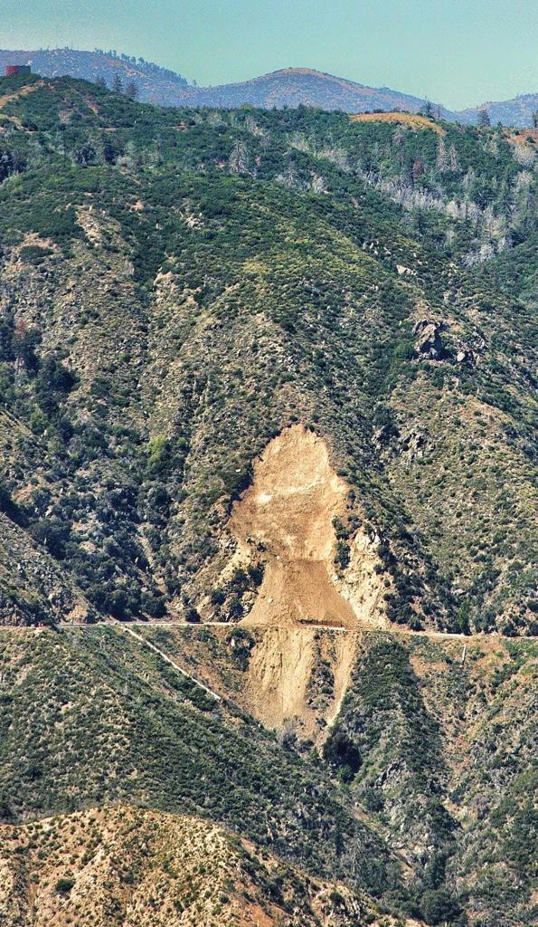

HikeUp: the water tank on the ridge towards the right of your photo is the West end of Barley Flats. The same tank is visible in one of courtney's photos. I still don't see it in your photo, though. It might be just out of view, or maybe behind something, since it's a very different angle.
Ah! I didn't notice the tank in her picture. Anyway, I had assumed it must be off to the right of the picture I took, behind the trees.dima wrote: ↑HikeUp: the water tank on the ridge towards the right of your photo is the West end of Barley Flats. The same tank is visible in one of courtney's photos. I still don't see it in your photo, though. It might be just out of view, or maybe behind something, since it's a very different angle.
-
Tom Kenney
- Posts: 351
- Joined: Sat Sep 29, 2007 7:51 pm
It's one of the bare patches in HikeUp's photo, right of center. The slide is in a western fork of Valley Forge Canyon, one ridge over from what looks like the more likely basin. The better angle is from the Wilson Rd between Eaton Saddle and the big cliff straight with stone wall. I was by there today, but neglected to stop for a pic, as I was dodging race cars.
Thanks, dima. I had used that water tank to explain the location to someone when the first slide happened.
EDIT: Here's a Goggle Maps link to exact point: the point
Thanks, dima. I had used that water tank to explain the location to someone when the first slide happened.
EDIT: Here's a Goggle Maps link to exact point: the point