

With a recent engagement told on the forum, I thought I would compile a post about romance in the San Gabriel mountains.
Not much on the internet. Sources describe the SG moutains as a bad or dark place...such as Mary Baxter & Alan Hoyt(teacher & student), or "Police speculated that Linda Sobek(model) may not have been the first pretty woman the strapping Rathbun had taken into Angeles Forest who didn't come out alive."
Not exactly the rave reviews places like Griffith Park or the Hollywood Hills get. One source questioned air temps in the mountains as being too cold at dusk or later, while others questioned the solitude of the mountains. Wind was a concern. I am not sure how G.Park and H.Hills are any better.
Marriage
Historically, there is Switzer Falls
http://www.aaaim.com/echo/v3n3/v3n3notestrails.htm
" It was Austin that built with donations the Christ’s Chapel on a rocky outcrop two hundred feet above the upper waterfalls. The Chapel and its amphitheater that sat two hundred people became a popular center for conferences, youth retreats, weddings and of course Sunday morning prayer"
Today, events take place on the outskirts with the San Gabriels as the backdrop....with places like Green Mountain Ranch(Lytle Creek), Villa del Sol D'Oro(Sierra Madre),Chantrelles(Padua Hills Theatre), Altadena Country Club, Descanso Gardens(La Canada) San Dimas Golf Course,Lindley-Scott House(Asuza), and certainly Wrightwood.
Not all events....for example,page 8 of http://issuu.com/hnabooks/docs/greenwedding
in which Sturtevant camp and its sister camps are used.
Romance
Perhaps the consensus is to research the spot before going. One wouldnt want to take someone to the West Fork San Gabriel river..that would be "fail"...especially when nearby is the East Fork, an improvement...and of course, timing is likely important in many good spots as well. Chantry Flats would be nice, but not nice to go to 12pm on a summer day when you cant find any parking. You see a negative review of Eaton canyon 'I took my girl and there were too many people'...ok, first, dont go there on Labor Day sir.......
Misc. News (Archive)
Sounds good to mecougarmagic wrote:The photo postcard - looks like Bonita Falls, doesn't it?
Certainly not an obvious trail. According to your link, its after BTN canyon...BTN canyon +1..hehehe. Somewhere in this picture is where the video footage is...Zé wrote:my guess is this: http://tinyurl.com/3xwr2q9

Four rescued after vehicle slides over embankment in Angeles National Forest
http://latimesblogs.latimes.com/lanow/2 ... orest.html
http://laist.com/2010/11/27/previously_ ... kers_r.php
"Search crews in Mount Baldy have located two young hikers reported missing Friday night, according to ABC Local. San Bernardino sheriff's officials with the help of volunteers were able to locate 13-year-old Raul Gutierrez and his 20-year-old cousin Oscar Monrreal who left for a hike on Friday morning with their dogs and did not return.
According to CBS Local, the hikers were attempting to take a short cut off the mountain near the San Bernardino county line approximately 55 miles east of Los Angeles.
“We were pretty high up in the mountains and we decided to take a short cut,” Oscar Monrreal said in an interview. “It was really rough terrain and we got lost." They were reportedly wearing winter gear and had a flashlight used to signal a search helicopter before spending the cold night sleeping under a bulldozer"
CA - San Gabriel Mountains - Mount Lowe Trail - Skeletal Remains Found - Nov'10
http://www.websleuths.com/forums/showth ... p?t=120573
ongoing thread regarding:
"...ALTADENA - Sunlight fell in hard patches Monday morning over the lush foothills inside the Cobb Estate, where authorities collected a set of human remains discovered Sunday by hikers about a half-mile up the Mount Lowe Railway trail...."
What gold looks like along the East Fork San Gabriel river
http://gpaatvp.com/forum/index.php?topi ... 775#msg775
Where is Old Man Rock?

http://adsabs.harvard.edu/full/1914PA.....22..471H
A:"very near the summit of MtWilson"
11/27/2010 13:19Sledding Injury Medical Aid Manker Flats-Movie Slope
Where is Movie Slope?
" the slope behind and seen from the campground, was dubbed "Movie Slope" for the frequent visits by actors popular in the 30s and 40s............In the 1940's, the first ski area was developed near Manker Flats, which was named Movie Slope after a motion picture was shot there.....Actually over the years several movies have been filmed either at the campgrounds adjacent to Movie Slope and on Movie slope.....We and the ski patrol also refer to Movie slope as Avalanche Slope"
^sounds like something to investigate further. For example...
http://www.anca.org/press_releases/pres ... ?prid=1715
"...The film was shot in less than one month in late 1918. Sets were built depicting Armenia, Mount Baldy represented Mt. Ararat, and desert scenes were reported to have been shot at Santa Monica beach. ..."
How to Photograph Stunning Waterfalls
http://photo.tutsplus.com/tutorials/sho ... aterfalls/
tutorial with an example of Sturtevant Falls
Report from the Board of Highway 39
http://glendoramtnroad.blogspot.com/201 ... ay-39.html
"...As of today I would not suggest riding hwy 2 above 39 to much snow and ice. Ice and snow could be a problem till 5500 feet or so. Top 3 miles of 39 horrid. Missing road, huge rocks and small landslides. Saw like three of them....
-Spoke to a cyclist today who rode up Highway 39 to the Coldbrook Gate. He respected the signage and didn't hop the gate. One of his friends received a $200 ticket in September for jumping the gate.
--Oh and $200 for 39! Its $400 for skating GMR! That's two tickets for the price of one! Seriously though you also have to go to court in Pomona if you get one of those tickets
Mickey Long, the public face of Eaton Canyon Wilderness Park, retires after 39 years
http://www.whittierdailynews.com/news/c ... z16iRUta56
"...After 39 years with the county parks system, more than 22 of them at Eaton Canyon....A recent study by Helen Wong, Eaton Canyon's superintendent, showed 270,000 visitors a year.
Not many will spot signs of the wildfires 17 years ago that scorched the earth, blackened trees and destroyed the old Nature Center, he said....Even now, with the recovery in its "final stages," he said, signs of the fire are there if you know where to look.
"Oaks are so strong, there are twigs burned brown and black that the fire killed, still there after 17 years," Long said. "I can see it, but I don't think the average visitor would..."
http://latimesblogs.latimes.com/lanow/2 ... orest.html
2 Young Hikers Rescued After Freezing Night On Mt. BaldyNovember 25, 2010 |
Four people were rescued late Thursday after a vehicle went over the side of the road and slid 250 feet down an embankment in the Angeles National Forest, a Los Angeles County fire dispatcher said.
The vehicle went over the side of Glendora Ridge Road, west of Mount Baldy Road about 8:30 p.m., said fire dispatch supervisor Andre Gougis.
Three people inside the vehicle were hurt. A fourth person who saw the accident and tried to help the victims had to be rescued as well, Gougis said
http://laist.com/2010/11/27/previously_ ... kers_r.php
"Search crews in Mount Baldy have located two young hikers reported missing Friday night, according to ABC Local. San Bernardino sheriff's officials with the help of volunteers were able to locate 13-year-old Raul Gutierrez and his 20-year-old cousin Oscar Monrreal who left for a hike on Friday morning with their dogs and did not return.
According to CBS Local, the hikers were attempting to take a short cut off the mountain near the San Bernardino county line approximately 55 miles east of Los Angeles.
“We were pretty high up in the mountains and we decided to take a short cut,” Oscar Monrreal said in an interview. “It was really rough terrain and we got lost." They were reportedly wearing winter gear and had a flashlight used to signal a search helicopter before spending the cold night sleeping under a bulldozer"
CA - San Gabriel Mountains - Mount Lowe Trail - Skeletal Remains Found - Nov'10
http://www.websleuths.com/forums/showth ... p?t=120573
ongoing thread regarding:
"...ALTADENA - Sunlight fell in hard patches Monday morning over the lush foothills inside the Cobb Estate, where authorities collected a set of human remains discovered Sunday by hikers about a half-mile up the Mount Lowe Railway trail...."
What gold looks like along the East Fork San Gabriel river
http://gpaatvp.com/forum/index.php?topi ... 775#msg775
Where is Old Man Rock?
http://adsabs.harvard.edu/full/1914PA.....22..471H
A:"very near the summit of MtWilson"
11/27/2010 13:19Sledding Injury Medical Aid Manker Flats-Movie Slope
Where is Movie Slope?
" the slope behind and seen from the campground, was dubbed "Movie Slope" for the frequent visits by actors popular in the 30s and 40s............In the 1940's, the first ski area was developed near Manker Flats, which was named Movie Slope after a motion picture was shot there.....Actually over the years several movies have been filmed either at the campgrounds adjacent to Movie Slope and on Movie slope.....We and the ski patrol also refer to Movie slope as Avalanche Slope"
^sounds like something to investigate further. For example...
http://www.anca.org/press_releases/pres ... ?prid=1715
"...The film was shot in less than one month in late 1918. Sets were built depicting Armenia, Mount Baldy represented Mt. Ararat, and desert scenes were reported to have been shot at Santa Monica beach. ..."
How to Photograph Stunning Waterfalls
http://photo.tutsplus.com/tutorials/sho ... aterfalls/
tutorial with an example of Sturtevant Falls
Report from the Board of Highway 39
http://glendoramtnroad.blogspot.com/201 ... ay-39.html
"...As of today I would not suggest riding hwy 2 above 39 to much snow and ice. Ice and snow could be a problem till 5500 feet or so. Top 3 miles of 39 horrid. Missing road, huge rocks and small landslides. Saw like three of them....
-Spoke to a cyclist today who rode up Highway 39 to the Coldbrook Gate. He respected the signage and didn't hop the gate. One of his friends received a $200 ticket in September for jumping the gate.
--Oh and $200 for 39! Its $400 for skating GMR! That's two tickets for the price of one! Seriously though you also have to go to court in Pomona if you get one of those tickets
Mickey Long, the public face of Eaton Canyon Wilderness Park, retires after 39 years
http://www.whittierdailynews.com/news/c ... z16iRUta56
"...After 39 years with the county parks system, more than 22 of them at Eaton Canyon....A recent study by Helen Wong, Eaton Canyon's superintendent, showed 270,000 visitors a year.
Not many will spot signs of the wildfires 17 years ago that scorched the earth, blackened trees and destroyed the old Nature Center, he said....Even now, with the recovery in its "final stages," he said, signs of the fire are there if you know where to look.
"Oaks are so strong, there are twigs burned brown and black that the fire killed, still there after 17 years," Long said. "I can see it, but I don't think the average visitor would..."
Hiker Found Hanging on Ledge in Eaton Canyon Area
http://altadena.patch.com/articles/hike ... ton-canyon
-Two men rescued from Eaton canyon cliffside after sketchy climb
From LASD website:"....The victim explained he had fallen from the hiking trail an unknown distance, and was hanging onto a bush to keep from falling off a cliff. He said he could not see his friend, but he could hear him as they shouted to one another a distance away. He could also hear a helicopter far away.
The victim explained that the two men had just gone for a day hike. They did not have backpacks, food or water, or warm clothing. He said he was injured, but didn't know the extent of his injuries. Deputy Toly said, "He said he was in pain and was worried he was going to go over the side of the cliff, but he did a great job of remaining calm. He is very lucky his cell phone worked in that area....Deputies hurried to find the two men, as the sun was going down and it was quickly getting dark..."
From linked website:"...I was the injured hiker whom you wrote about. My name is Eric and I am currently at the San Gabriel Hospital. If you have the time would you like to interview me? I can sell you the story and you can take a picture of me with my friend"
Angeles Crest Highway 2 could be reopened this month, officials say 12/12/10
http://www.whittierdailynews.com/news/c ... z188LYawNB
"...Now, officials are hopeful the road will reopen in mid- to late December, barring any more weather setbacks.
"I was just up there (Wednesday)," Caltrans spokesman Patrick Chandler said. "It looks a lot better. It should be within a couple weeks or so that it will be open to the general public...The road remains closed to the public until Caltrans officially opens it. Hikers, bicyclists or anyone caught in areas closed by Caltrans may be cited, Chandler said."
O/T:Search and Rescue Saves Climbers - Santa Barbara 12/13/10
http://www.edhat.com/site/tidbit.cfm?nid=44710
"...they became stranded approximately 150 feet up from the pools below. Being unable to move any further up or retrace their climbing moves back down, one of the two free climbers was able to get a cellular signal to call 9-1-1 for help as he held onto the cliff face....There were no injuries to either climbers or the rescuers."
O/T:CA: "Don’t get lost while hiking" - Ventura County sherrifs
http://www.jocosarblog.org/jocosarblog/ ... iking.html
"...During the past few weeks, people have been getting lost in the Ventura County backcountry on a regular basis. In November at least 13 people were lost or stranded and needed rescuing at night by the sheriff’s department helicopter crew or volunteer search and rescue teams...."
O/T: Update on NM SAR tradegy 6/2009
http://www2.wnct.com/lifestyles/2010/de ... ar-607658/
"A former state police chief pilot says there was pressure to fly rescue missions from the Public Safety Department's top administrator, and that may have contributed to a fatal crash in which a helicopter went to save a lost hiker near Santa Fe, according to a report by federal investigators.The report by the National Transportation Safety Board also raised questions about a pilot's decision to fly the rescue mission and whether the pilot was overworked before starting the mission, and it disclosed he was taking prescription medication for depression...The NTSB report, part of hundreds of pages of documents released on the agency's website last week, did not reach a conclusion about the cause of the accident. A separate report on that is not expected until early next year.....State Police Chief Faron Segotta said, "Nobody ever told a pilot they had to fly."..."
historical:Mt Lowe, California - the railway into the clouds
http://transpressnz.blogspot.com/2010/1 ... louds.html
"....The most impressive part of the railway was the third division or Alpine Division opened in 1896 which consisted of 3.5 miles (5.6 km) of narrow gauge track with 127 curves and 18 bridges and trestles. On this line there were three cars available for shuttling between the station of Echo Mountain and the end-of-line, though only one car ever operated at a time due to electrical limitations, and there was no two-way traffic. The division spanned the broad face of Las Flores Canyon, rounded a promontory called the Cape of Good Hope, travelled deep into Millard Canyon, reappeared at the front face of the mountain, and eventually disappeared into Grand Canyon where it terminated at the foot of Mount Lowe. This location was called Crystal Springs at an elevation of 4,995 ft (1,522 metres) for a stream of water that poured from the hillside. A 12-room Swiss-style chalet called Ye Alpine Tavern was built here.
After a major rainstorm "washed most everything off the mountain sides" in 1938, the railway was abandoned."
Bottomless lake aka Lost Lake
http://networkedblogs.com/bFR7k
"But first we have to find the Bottomless Lake! It is not clear to me how the whole thing started, but a short Google search reveals discussions of the mysterious bottomless lake in Cajon Pass....Of course one can see the bottom of the lake in the GoogleEarth image, and the crime report I read noted that divers looking for the body mentioned that the the lake is barely 20 feet deep.The lake has been a trash heap and hangout for undesirable people over the years, but it looked on my visit like the Forest Service was trying to improve the situation. There was not as much trash as I remembered from the past, and signs noted that a recreation fee was required for parking. The cattails were healthy too.A short walk up the hill provides a view of the fault scarp and the Blue Cut, an exposure of the mangled and broken rock within the fault zone...."
O/T: Keep it wild
http://lpfw.org/docs/Newsletters/2010_02Winter.pdf
"Mike Splain, Development Director of the Ventana Wilderness Alliance,shares his amazing {solo} encounter with a mountain lion in the northern LosPadres National Forest....Abruptly drawn back into the present, the tension nears breaking point. She shivers with agitation, seeming certain that I will turn tail, but as I back away, using caution not to jostle or slip, she pivots, scans the slopes behind and beats a hasty retreat up the near vertical riverbank. It’s as difficult to walk away as it was to stay put, but several hundred yards later, peaceful headspace returns and the gravity of what’s just happened begins to sink in...."
Life on the Arroyo Seco
http://southpasadena.patch.com/articles ... rroyo-seco
"....Spanish soldier Gaspar de Portola originally explored the Arroyo Seco and other Los Angeles River tributaries in 1770. He came up with the name Arroyo Seco because, out of all the canyons he had seen, this one had the least amount of water. Fed by the trickling stream, land along the Arroyo proffered overflowing vines of wild roses, grapes and blackberries...After the devastating Los Angeles floods of 1938, the Arroyo was paved into the familiar concrete channel we know today...."
more romance items: ^"I was shooting pictures of a particularly glorious sunset there one night last year when I saw a man take his girlfriend's hand, get down on his knees and pull out a little black box. I tried not to spy, but based on the happy shrieks followed by lingering kisses, her answer was yes."
http://www.smdp.com/Articles-c-2010-12- ... -wild.html
" ...On their first date, they went on a night run on the Mount Wilson Trail in the San Gabriel Mountains."We started at 7 p.m. on a rainy evening, jogged all the way to the summit and down … . It was 2 a.m. [when we finished]. It was a weekday, and I said, 'That girl is for me,'" said Chaigneau, 35, who has since climbed the highest peak in North America, Europe and South Africa with Lam...."
http://www.pasadenastarnews.com/columnists/ci_16765809
"...There could be nothing more Altadena than Zane Grey's description of meeting his future mistress Brenda Montenegro while hiking in Eaton Canyon(1920s): "I saw her flowing raven mane against the rocks of the canyon. I have seen the red skin of the Navajo, and the olive of the Spaniards, but her ... skin looked as if her Creator had in that instant molded her just for me. I thought it was an apparition. She seemed to be the embodiment of the West I portray in my books, open and wild..."

Who knew the San Gabriels were so romantic? Richard Piotrowski posted these pictures from a recent group hike on the Whitney Portal Store Message Board.AW wrote: ↑more romance items: ^"I was shooting pictures of a particularly glorious sunset there one night last year when I saw a man take his girlfriend's hand, get down on his knees and pull out a little black box. I tried not to spy, but based on the happy shrieks followed by lingering kisses, her answer was yes."
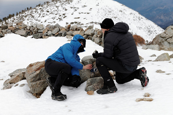
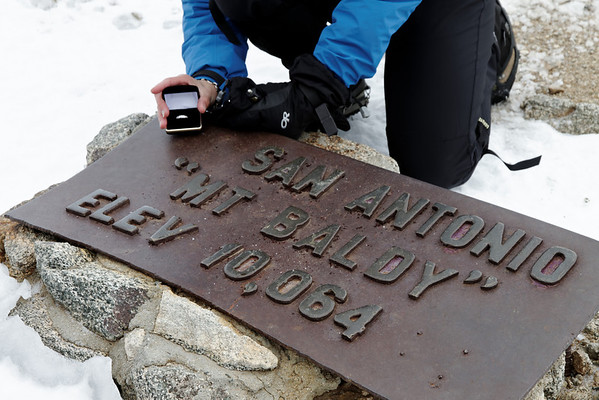
^Thats pretty cool AlanK....
SierraDescents finds the same rainy conditions on the Ski Hut trail....
http://www.sierradescents.com/current-c ... hower.html
video of creek across MtBaldy Road
http://www.sierradescents.com/tools/images/2010/rain.mp4
Pictorvision flies through Angeles Forest canyon
-apparently this is some fancy camera stabilization
MtWaterman.org
12-19-2010
The Angeles Crest Hwy and all roads to Mt Waterman are closed until further notice.
THe Forecast is calling for heavy raqin until Tuesday and then it turns to heavy snow with the snow level at 6000 feet. NWS is now showing around 4 feet of new this week in the parking lot.
Video:Hummer tows BMW back to ACH
Pretty much everything closed, western half(all access roads, Chaney trail, etc) and Lytle Creek on the Eastern half..video of Eaton creek
http://altadena.patch.com/articles/pict ... eo-4058599
Update to case April 26, 1994
http://articles.latimes.com/1994-04-26/ ... st-highway
"A Pasadena man lost an eye Monday when a motorist stopped in front of his car on Angeles Crest Highway and allegedly shot him....He said two off-duty sheriff's deputies witnessed the incident and followed Shinkman to a service station in La Crescenta, where he was calling authorities to say he had shot a man"
Update: Jury Finds Not Guilty of Attempted Murder Despite Sheriff's Eye-Witness Testimony (Case # BA014456):
http://www.spigalaw.com/case-results.html
http://articles.latimes.com/1994-06-08/ ... st-highway
SierraDescents finds the same rainy conditions on the Ski Hut trail....
http://www.sierradescents.com/current-c ... hower.html
video of creek across MtBaldy Road
http://www.sierradescents.com/tools/images/2010/rain.mp4
Pictorvision flies through Angeles Forest canyon
-apparently this is some fancy camera stabilization
MtWaterman.org
12-19-2010
The Angeles Crest Hwy and all roads to Mt Waterman are closed until further notice.
THe Forecast is calling for heavy raqin until Tuesday and then it turns to heavy snow with the snow level at 6000 feet. NWS is now showing around 4 feet of new this week in the parking lot.
Video:Hummer tows BMW back to ACH
Pretty much everything closed, western half(all access roads, Chaney trail, etc) and Lytle Creek on the Eastern half..video of Eaton creek
http://altadena.patch.com/articles/pict ... eo-4058599
Update to case April 26, 1994
http://articles.latimes.com/1994-04-26/ ... st-highway
"A Pasadena man lost an eye Monday when a motorist stopped in front of his car on Angeles Crest Highway and allegedly shot him....He said two off-duty sheriff's deputies witnessed the incident and followed Shinkman to a service station in La Crescenta, where he was calling authorities to say he had shot a man"
Update: Jury Finds Not Guilty of Attempted Murder Despite Sheriff's Eye-Witness Testimony (Case # BA014456):
http://www.spigalaw.com/case-results.html
edit: couldnt find what date this guy was found not guilty..probably old news...nor why he was found not guilty, but he did claim "alleged that Milovic(dead person) had tailgated Shinkman(shooter) in "a cat-and-mouse situation that had created reasonable fear in Shinkman's mind."The defendant in this case, an LAPD mechanic, was charged with attempted murder after an off-duty Sheriff’s deputy allegedly witnessed him shooting a man in the head while parked along Angeles Crest Highway. The victim’s car went over an embankment and plunged 200 feet down a mountainside. Miraculously, he lived – but the bullet did take out the alleged victim’s eye. Nevertheless, Carlo Spiga obtained a Not Guilty verdict on attempted murder and the defendant, who was looking at life in prison, was released with time served
http://articles.latimes.com/1994-06-08/ ... st-highway

"Alleged victim?" WTF?
Nunc est bibendum
Coroner: Snowboarder wasn't wearing helmet before fatal crash
http://www.contracostatimes.com/califor ... ck_check=1
"A 24-year-old man who crashed into trees while snowboarding in Wrightwood and died was not wearing a helmet at the time of his fatal accident, a coroner's official said today.....Ski patrol and firefighters responded to the Mountain High Resort in the east San Gabriel Mountains at about 6 p.m. Monday after the snowboarder crashed into some trees.
He was taken to a hospital in San Bernardino, where he was pronounced dead.The crash occurred on a lighted run called "Headwall," near the bottom of the north-facing mountains that compose the ski area."
Hiker Injured in 80 Foot Fall Above Eaton Canyon
http://altadenarescue.blogspot.com/2010 ... above.html
http://altadena.patch.com/articles/girl ... tmas-night
"....I decided to swing past the Pinecrest gate on the Mount Wilson Toll Road, which has been the subject of some controversy due to the fact that this public trail head is gated and that the keys to the gate are in the hands of private individuals.
About 5:30 p.m. we got to the gate and discovered a female hiker named Vivian and her dog trapped behind the gate.
Vivian, 24, cried during the entire time I talked to her. She was dressed in a long sleeved T-shirt and running shorts and was already shivering. She said she knew the gate was locked at sunset and thought she was in time but arrived to find the gate locked. I started to explain the other ways to get out of Eaton Canyon but stopped when it became clear she was not up to it....According to Sgt. Tania Plunkett of the Crescenta Valley Sheriff's Station, Altadena Sheriff's deputies unlocked the gate for Vivian at 6:50 p.m...."
Offroader: 'I was stupid'
http://www.avhidesert.com/forum/showthr ... 2&pid=3347
"...Just below Littlerock Dam, where water poured over the spillway and into Little Rock Wash, firefighters on Thursday afternoon rescued three Santa Clarita teenagers from a pickup truck that drove around a barricade and the locked gate at Mount Emma Road and into rushing water.
"I was stupid," said the 19-year-old driver, who wouldn't give his name. "I was off-roading and figured I would get my car clean."
The truck got stuck beneath high-power lines, so firefighters couldn't use a helicopter to reach the driver and two young women. Instead, firefighters hooked to safety ropes waded into the water and brought the trio to safety. The pickup truck remained in the wash, submerged above its wheels...."
Kids Blamed For Afternoon Fire
"....Fire crews at the scene said at least three children under the age of 10 were playing with matches, setting the storage shed on fire...Fire officials said it happened just before 2 p.m. Sunday near the intersection of Mount Baldy and Sierra Madre."
^Hehehe, OK that fire happened in El Paso, Texas...
http://www.contracostatimes.com/califor ... ck_check=1
"A 24-year-old man who crashed into trees while snowboarding in Wrightwood and died was not wearing a helmet at the time of his fatal accident, a coroner's official said today.....Ski patrol and firefighters responded to the Mountain High Resort in the east San Gabriel Mountains at about 6 p.m. Monday after the snowboarder crashed into some trees.
He was taken to a hospital in San Bernardino, where he was pronounced dead.The crash occurred on a lighted run called "Headwall," near the bottom of the north-facing mountains that compose the ski area."
Hiker Injured in 80 Foot Fall Above Eaton Canyon
http://altadenarescue.blogspot.com/2010 ... above.html
Young Woman Trapped Behind the Pinecrest Gate on Christmas NightDecember 28, 2010
AMRT Members and the Los Angeles County Sheriff's Air 5 Helitac Team responded to a distress call reporting a severely injured hiker who plunged approximately 80 feet from a rock cliff near the Eaton Canyon Waterfall shortly after 5 p.m. The Air 5 crew extracted the male victim and transported him to Huntington Memorial Hospital in Pasadena.
The injured male was hiking in Eaton Canyon with a group of nine people. One other group member sustained minor injuries and was treated and released at the scene.
http://altadena.patch.com/articles/girl ... tmas-night
"....I decided to swing past the Pinecrest gate on the Mount Wilson Toll Road, which has been the subject of some controversy due to the fact that this public trail head is gated and that the keys to the gate are in the hands of private individuals.
About 5:30 p.m. we got to the gate and discovered a female hiker named Vivian and her dog trapped behind the gate.
Vivian, 24, cried during the entire time I talked to her. She was dressed in a long sleeved T-shirt and running shorts and was already shivering. She said she knew the gate was locked at sunset and thought she was in time but arrived to find the gate locked. I started to explain the other ways to get out of Eaton Canyon but stopped when it became clear she was not up to it....According to Sgt. Tania Plunkett of the Crescenta Valley Sheriff's Station, Altadena Sheriff's deputies unlocked the gate for Vivian at 6:50 p.m...."
Offroader: 'I was stupid'
http://www.avhidesert.com/forum/showthr ... 2&pid=3347
"...Just below Littlerock Dam, where water poured over the spillway and into Little Rock Wash, firefighters on Thursday afternoon rescued three Santa Clarita teenagers from a pickup truck that drove around a barricade and the locked gate at Mount Emma Road and into rushing water.
"I was stupid," said the 19-year-old driver, who wouldn't give his name. "I was off-roading and figured I would get my car clean."
The truck got stuck beneath high-power lines, so firefighters couldn't use a helicopter to reach the driver and two young women. Instead, firefighters hooked to safety ropes waded into the water and brought the trio to safety. The pickup truck remained in the wash, submerged above its wheels...."
Kids Blamed For Afternoon Fire
"....Fire crews at the scene said at least three children under the age of 10 were playing with matches, setting the storage shed on fire...Fire officials said it happened just before 2 p.m. Sunday near the intersection of Mount Baldy and Sierra Madre."
^Hehehe, OK that fire happened in El Paso, Texas...

Driver rescued a day after SoCal forest plunge Tues 1/4/11
http://www.sfgate.com/cgi-bin/article.c ... z1A8QGdBQw
http://www.firsttracksonline.com/News/2 ... -Mt-Baldy/
"A 42-year-old Hermosa Beach, Calif. man survived a snowy night on Mt. Baldy after getting lost snowboarding at the southern California ski area on Sunday.....Gonzalez contacted the San Bernardino County Sheriff's Department by cell phone around 4:30 p.m. Sunday, indicating his predicament.
Search and rescue crews were dispatched to the area, but were unable to locate Gonzalez as snow began to fall upon the region in earnest, with snow levels dipping to as low as 3,000 feet overnight Sunday into Monday morning. Gonzalez again phoned the Sheriff's department at 9:45 a.m. Monday to indicate that he had found his way to a shooting range(Lytle Creek)."
^Lytle Creek road appears to remain closed and in major need of repair.
Pure Bliss
http://hankstrailmix.blogspot.com/2011/ ... bliss.html
Mt.Bliss trail run....picture of bear print
http://3.bp.blogspot.com/_F7nC6NWgWnc/T ... 110742.jpg
End the year and post with some kayak action
http://www.sfgate.com/cgi-bin/article.c ... z1A8QGdBQw
California Man Survives Unplanned Night on Mt. BaldyThe driver of a vehicle that plunged 150 feet down an embankment in the mountainous Angeles National Forest has been found alive a day after the plunge.
Los Angeles County fire Inspector Matt Levesque says skid marks led authorities to the San Gabriel Canyon Road crash site at mile marker 20 near a reservoir about 30 miles northeast of downtown Los Angeles.
He says the man told firefighters his vehicle went over the side Monday afternoon.
Rescuers carried the man up a steep slope to an ambulance.
http://www.firsttracksonline.com/News/2 ... -Mt-Baldy/
"A 42-year-old Hermosa Beach, Calif. man survived a snowy night on Mt. Baldy after getting lost snowboarding at the southern California ski area on Sunday.....Gonzalez contacted the San Bernardino County Sheriff's Department by cell phone around 4:30 p.m. Sunday, indicating his predicament.
Search and rescue crews were dispatched to the area, but were unable to locate Gonzalez as snow began to fall upon the region in earnest, with snow levels dipping to as low as 3,000 feet overnight Sunday into Monday morning. Gonzalez again phoned the Sheriff's department at 9:45 a.m. Monday to indicate that he had found his way to a shooting range(Lytle Creek)."
^Lytle Creek road appears to remain closed and in major need of repair.
Pure Bliss
http://hankstrailmix.blogspot.com/2011/ ... bliss.html
Mt.Bliss trail run....picture of bear print
http://3.bp.blogspot.com/_F7nC6NWgWnc/T ... 110742.jpg
End the year and post with some kayak action
Photo(copyrighted):San Gabriel mountains bighorn sheep lambs
Not much news to report as time to hand out adventure pass tickets and snow/water conditions remain healthy:
01/10/2011 09:17 NNC's/No Passes Mt Baldy .
01/10/2011 09:16 50 NNC's/No Passes Mt Baldy .
01/10/2011 09:15 11 NNC's/No Passes Mt Baldy .
01/10/2011 09:14 41 NNC's/No Passes San Gabriel Canyon .
01/10/2011 09:13 18 NNC's/No Passes San Gabriel Canyon .
01/10/2011 09:10 No Adventure Passes San Gabriel Canyon
Speaking of water...a lot of water.......
Resorts drawn to Mount Baldy
http://www.sbsun.com/news/ci_17060632
The massive granite peak known as Mount Baldy straddles San Bernardino County's western border with Los Angeles County and has become one of Southern California's best-known landmarks. At 10,064 feet, the mountain is the crowning high point of the rugged San Gabriel mountain range.
In official records and on maps, the mountain is called Mount San Antonio, with the name Mount Baldy usually following in parentheses. The more informal name came into wide use shortly after the first pioneers began scrambling up its rocky slopes in the late 1860s. Since that time, locals have affectionately called it Mount Baldy (or sometimes Old Baldy) because of its barren treeless summit.
When the mountain took on its formal name commemorating St. Anthony of Padua, a Franciscan priest, miracle worker and saint, is not known. One of the earliest documented mentions of the name came in March 1774, when the early Spanish missionary-explorer Francisco Garces passed by the mountain and made note of "Arroyo San Antonio" in his diary.
The first government use of the name occurred in an 1861 report by Josiah D. Whitney, director of the California Geological Survey. By the early 1870s, surveyors had calculated its height to be above 10,000 feet.
Aside from its geographic prominence and beauty, the mountain has a fascinating history as a mining, recreational and residential community.
Following the gold rush of 1849, Southern California was teeming with miners, and by the 1860s prospectors were digging into the crags and streams of Mount Baldy.
Many of the early mining claims were staked at a place called Baldy Notch, a small and relatively flat spot on the mountain, southeast of the summit at the 7,800-foot level (site of the present-day Baldy Notch Restaurant). By 1879, there were six mining outfits working on the mountain, and the Los Angeles Herald newspaper reported they were all "confident of striking it rich."
Some of the operations employed hydraulic mining, which uses a high-pressure water jet to wash dirt and rock into catch basins, where the heavier gold can be separated.
While efficient in terms of mining, the process polluted the water that was used for drinking and irrigation by customers downstream in the Pomona Valley. An injunction was served by the San Antonio Water Company that prohibited any mining that could foul the water supply.
In 1894, a small rustic resort known as Dell's Camp was established by Frank Keyes in the area of today's Baldy Village. The resort gained reputation, but getting there required the use of pack animals until a wagon road was opened in 1903.
In 1906, Charles R. Baynham opened a more ambitious resort directly across from the old Dell's Camp. Baynham's resort later developed into the very popular Camp Baldy. The establishment of Camp Baldy opened the way for several new resorts including Icehouse Canyon, Eleven Oaks, and Snow Crest.
Vacation cabins were built up around the resorts and they developed into small communities. As the communities grew, stores, restaurants, a post office, and a school house were built to accommodate the residents.
The Camp Baldy resort began its golden years when it was purchased by Foster and Ruth Curry in 1928. The Curry family had operated the famous Camp Curry in Yosemite, and they went on to develop Camp Baldy into one of the premier resorts in Southern California.
Sadly, the great flood of 1938 washed away much of Camp Baldy, as well as hundreds of private cabins and businesses, and major sections of roads. The resorts never regained their previous luster, but the surrounding communities rebuilt and continued to grow.
One of the most unique chapters in Mount Baldy's history began in 1920, when the brilliant American physicist Albert Abraham Michelson began developing a process to accurately measure the speed of light.
Michelson devised an experiment to send a beam of light some 22 miles from Mount Wilson to special mirrors affixed to Lookout Mountain, a prominent point on Mount Baldy. Over a two-year period, Michelson arrived at the most accurate measurement of the period.
As the resort communities were developing on Mount Baldy, Southern California ski enthusiasts were searching for suitable ski slopes in the local mountains. In 1922, local ski pioneer George Bauwens became the first man to reach Baldy's summit on skis.
In 1935, the Ski Mountaineers section of the Sierra Club obtained permission from the Forest Service to construct a ski hut on the slopes of Mount Baldy. A site was chosen at the base of the Baldy Bowl, a steep broad slope that rises nearly to the summit of the mountain.
Construction began in October 1935, and in January 1936 a sturdy 14-foot-by- 24-foot hut was completed. That hut was destroyed by fire in September 1936, but it was replaced immediately by a slightly larger structure that still stands today.
The first San Antonio Downhill and Slalom Championship was held at the Baldy Bowl in March 1935.
Local skiers Herb Leffler and Jim Chaffee took the first serious steps toward developing Mount Baldy into a ski resort in 1944. The men set up a rope tow powered by a Hudson engine and invested $150 to buy fuel and supplies for their first season. By the 1947-48 season, Leffler and Chaffee were advertising the Mount Baldy Ski Tows in magazines, and their first race was held on a run known as Movie Slope.
In December 1952, the Mount Baldy Ski Lifts, as the operation was called, boasted two chairlifts and a restaurant at Baldy Notch. Over the years, more lifts, ski trails, and modern snowmaking equipment have been added, making Mount Baldy one of the most popular winter resort areas in Southern California...
-
LetsGlissadeLhotze
- Posts: 20
- Joined: Tue Jan 11, 2011 9:50 pm
If I were search and rescue I would ask the party if they were in good health and then tell them to go figure it out..... What's up with all these pre-rescue rescues?? its like people are so lazy as soon as they become disoriented or feel challenged they give up like "ok I quit, can I be rescued now" My motorcycle broke down at Mt waterman at 1230 in the morning after I midnight summit and I walked my ass 35 plus miles down untill I collapsed and hitched a ride at 9 am the next morning. 9 Freaking hours!!! but I would never call to be "rescued" from my own stupidity ... its not a pride thing its just not fair. when you screw up you deal with it...
The violin was his axe. Or vice versa.From City News Service
Posted: 01/22/2011 12:16:20 PM PST
ALTADENA - A hiker who injured a wrist in a fall in the mountains north of Altadena and two young men who got into trouble in steep, narrow Eaton Canyon were safe Saturday, thanks to deputies, volunteers and a helicopter crew.
A Rosemead man who injured a wrist in Las Flores Canyon near Echo Mountain was pulled out of a ravine about 6:30 p.m. Friday and walked out of the area, according to deputies at the Crescenta Valley Station.
"This was the second rescue response by Altadena Sheriff's Station deputies in less than two hours," Capt. Mike Parker of the Sheriff's Headquarter's Bureau said.
Two 20-something men from South Pasadena, one of them carrying a violin, were airlifted out of Eaton Canyon near the lower waterfalls. One them called 911 for help when they were apparently unable to descend a section.
Other hikers in the area offered jeers, but no help, officials said.
The two men were looking for a "scenic precipice" where the violinist could play his music, Parker said.
The pair, who were uninjured, were airlifted out of the canyon, he said.
Read more: http://www.pasadenastarnews.com/news/ci ... z1BntPBO2T
I'm sorry -- but going by what I saw on that live tv rescue of violin boy in Eaton - this is a time when maybe they should just let him spend the night up there and think about all the danger he caused - that or fine his butt for that helicopter ride.
Any fool should know not to end up where he ended up. Next time, take a trumpet up there and play 'Taps'...
Any fool should know not to end up where he ended up. Next time, take a trumpet up there and play 'Taps'...
Campgrounds in the works in local mountains
http://articles.glendalenewspress.com/2 ... -mountains
"Overnight campgrounds nestled among Glendale's 5,000-plus acres of open space are on the drawing board as city parks officials launch two public input meetings next week....Weinstein said possibilities include a drive-in site at Deukmejian Wilderness Park in the San Gabriel Mountains and a hike-in site in the Verdugo Mountains. He said both areas would be dedicated to "primitive camping" — without electricity. The city would consider budget constraints when deciding whether to provide amenities such as potable water or permanent restrooms, he said...."
Fish Canyon Falls Hike 1/29/11
http://danshikingblog.blogspot.com/2011 ... -2011.html
"...On Tuesday, January 25, voters in Azusa made a decision that will forever and inextricable change the face of Fish Canyon. In a 2-1 margin of victory, Azusans voted to uphold a July 17, 2010 city council decision which approved a new mining plan for Vulcan Materials, which owns 270 acres at the mouth of Fish Canyon.....Eric from Vulcan reports that there were 457 hikers today...I am excited about the new easy-access trail that will be built through the quarry as part of the new mining plan. Hikers will be able to enjoy a nice 5-mile hike 24/7/365. No more shuttles and crowds and time constraints."
Still no news on whats happening with Lytle Creek road...but Bonita Falls is in reach
videos:
HELICOPTER RESCUE, EATON CANYON HIKING INJURY
voyeuristic view of rescue of teenage girl who fell near Eaton Canyon Falls, although nothing graffic.
Bridge to Nowhere - Helicopter - Unedited - Aerial
Short High-def fly over of BTN, with footage of Airplane Flats.
Nothing wildlife related, so from the Wrightwood forum, a link to another video of how hawks see the world
http://wimp.com/hawkssee
Also, for Ventura county:
Peakbagger's 1 day Ojai Triple Crown. Sisar>Hines>Topa Topa>Chief>Thatcher. 28 miles, 7,000 feet of up, 13 hours.
http://davidstillman.blogspot.com/2011/ ... crown.html
"Sisar Road (start): 05:35
White Ledge Camp: 07:05/mile 4.5
Bench on the Ridge: 08:10/mile 6.5
Saddle: 09:05/mile 8
Lady Bug Junction: 09:55/mile 11
Hines Peak summit: 10:30/mile 11.5
Topa Topa summit: 12:15/mile 14
Chief Peak: 15:10/mile 20
Horn Canyon Trail: 16:40/mile 24
Thatcher School: 18:35/mile 28 Total Time: 13:00 hrs"
-
davantalus
- Posts: 203
- Joined: Mon Jun 08, 2009 9:09 am
My buddy, Garret Baquet shot this a few months back. You can find him at http://www.baquetphoto.com he's also the cinematographer for the excellent web series, http://tyranny.tv
Davantalus- nice shots of MtSan Jacinto by your buddy...now if someone would fly a helicopter north along the West Fork Bear Creek 
Biker Rescued After Tumbling Off Canyon Road in Glendora
http://www.ktla.com/news/landing/ktla-m ... 6317.story
"A 22-year-old mountain biker was hospitalized after tumbling off a steep embankment in Glendora Monday morning.
The biker fell about 300 feet into a canyon near Glendora Mountain Road at Glendora Ridge Mountainway a few minutes after 10 o'clock, according to L.A. County Fire officials....And had he not had his cell phone, he would have been trapped in the canyon for hours or days, with life-threatening injuries.
"We would have found a dead body... absolutely," Desmarteau said.
The biker has some broken ribs, a collapsed lung and a sore neck and back, but he is expected to make a full recovery....."
Hi-resolution video of a rescue of car off the side Glendora Mountain road 11/5/10
Taking the Plunge in Big Tujunga Canyon
http://www.crescentavalleyweekly.com/ne ... ga-canyon/
"Before descending down a mountain of rocks underneath the second bridge in Big Tujunga Canyon, Fred Wenzel goes over his checklist, making sure he has the right equipment and is properly secured for his big test....Wenzel completed his training over the weekend to become the newest member of the Montrose Search and Rescue Team..."
Lessons from the Plight of Frogs in Southern California
http://anuranblog.blogspot.com/2011/01/ ... gs-in.html
"Researchers and managers from California and Nevada held their annual Amphibian Populations Task Force meeting January 6-7, 2011, this time in Yosemite Valley. With more than 100 attendees, the meeting once again provided a great opportunity to hear about the status of myriad frog conservation projects and catch up with colleagues. For me, the most insightful talk was that by Adam Backlin, the USGS scientist who with Robert Fisher (also with USGS), has been leading efforts to restore southern mountain yellow-legged frog populations (Rana muscosa) in the Transverse and Peninsular Ranges in southern California. This group of populations was listed as endangered under the U.S. Endangered Species Act in 2002.
Starting with only 150 frogs scattered across several populations and mountain ranges, the efforts to keep southern California R. muscosa from going extinct have begun to produce promising results. The removal of non-native rainbow trout from a reach of Little Rock Creek has allowed the resident R. muscosa population to begin to expand. The recovery of this population is still in its early stages but the fact that this population has increased to approximately 50 frogs from just a handful since fish removal is a very promising start.
Thanks to the efforts by staff at the San Diego Zoo, researchers now have access to captive-bred R. muscosa for use in reintroductions. Reintroductions using this captive stock were conducted for the first time in 2010 so it is still too early to know the outcome of these efforts. But just having the captive colony available to allow reintroductions is a huge step forward..."
Bobcats on Alzada Rd.
http://www.altadenablog.com/2011/02/bob ... da-rd.html
http://www.tragic-christian.org/.a/6a00 ... 970c-800wi
Pacific Crest Trail Data Book - Section D
http://postholer.com/databook/index.php?sec=d
A bunch of stats on the section of the PCT passing through the Angeles Forest.
blog:On Being Simply True
blog written from residence near MtBaldy
sample: http://skaymurphy.blogspot.com/2010/08/ ... eaven.html -a hike along San Antonio Creek
"...Water still spills over rocks, and I fall asleep at night directly under an open window, hearing the music it makes as it dances down the canyon.
The morning after my return home, I climbed down into the canyon and hiked up the stream. This is where I find tranquility. Rarely does anyone else hike the stream bed.....As I walk on this particular morning, I stop to watch a hummingbird feed from wild red columbine. Overheard, a red shafted flicker lets me know he is wary of my presence, though the hummer doesn’t seem to mind. A huge yellow and black butterfly drifts by—papilionidae—the “swallowtail” butterfly that was a magical creature to me in my childhood… and still is. Farther up the stream, I stop for a drink of water, setting the backpack beside the stream, and I nearly tread on an alligator lizard as I step back into the water. He is magnificent as he suns himself, and I watch him until he becomes self-conscious and scuttles under a rock.
Finally, I reach The Flat Rock, a huge boulder that I climb up on to rest and eat lunch. The stream runs over half of it, so I sit on the smooth dry side, the water flowing just inches from me. As I sit, I can look down to the valley. I hear nothing but birdsong over the sound of the stream on this brilliant day..."
Historical: Christmas at the Sierra Madre Villa Hotel -- 1878
http://eastofallen.blogspot.com/2010/12 ... hotel.html
"...The year was 1878 and it was Christmas-time at the Sierra Madre Villa Hotel. Only five years earlier, noted painter William Cogswell had purchased 473 acres of wild mesa land in the vicinity of present day Eaton Canyon Golf Course. After Cogswell's purchase, the hard work began and the property was soon transformed into one of the west coast's preeminent resorts.... I will describe a typical Christmas day in the late seventies. The day before Christmas was one of excitement for all were preparing the gifts, some driving into Los Angeles, a thirty mile drive, to get the last few gifts needed and to shop for all the rest and only about two dry goods stores, two book stores and a few other places to purchase but that made it all the more exciting. There was a tree to sit up fully nineteen feet high, that was the height of the ceiling, and a spread of branches in proportion. Then the trimmings, popping the corn and putting on the cornucopias, hanging the glass balls and the angel on the top. That day the Chinese boy, Sam, made mysterious trips to Mother's room with packages coming from the servants and Chinese on the ranch......Christmas morning the coach that ran to the San Gabriel Southern Pacific Railroad Station daily for the mail and passengers, was ready to take any who might wish to go to the Episcopal Church in San Gabriel, as was the custom on Sundays. Then the day passed and all were in readiness for the big event in the evening with the Christmas tree..."
Biker Rescued After Tumbling Off Canyon Road in Glendora
http://www.ktla.com/news/landing/ktla-m ... 6317.story
"A 22-year-old mountain biker was hospitalized after tumbling off a steep embankment in Glendora Monday morning.
The biker fell about 300 feet into a canyon near Glendora Mountain Road at Glendora Ridge Mountainway a few minutes after 10 o'clock, according to L.A. County Fire officials....And had he not had his cell phone, he would have been trapped in the canyon for hours or days, with life-threatening injuries.
"We would have found a dead body... absolutely," Desmarteau said.
The biker has some broken ribs, a collapsed lung and a sore neck and back, but he is expected to make a full recovery....."
Hi-resolution video of a rescue of car off the side Glendora Mountain road 11/5/10
Taking the Plunge in Big Tujunga Canyon
http://www.crescentavalleyweekly.com/ne ... ga-canyon/
"Before descending down a mountain of rocks underneath the second bridge in Big Tujunga Canyon, Fred Wenzel goes over his checklist, making sure he has the right equipment and is properly secured for his big test....Wenzel completed his training over the weekend to become the newest member of the Montrose Search and Rescue Team..."
Lessons from the Plight of Frogs in Southern California
http://anuranblog.blogspot.com/2011/01/ ... gs-in.html
"Researchers and managers from California and Nevada held their annual Amphibian Populations Task Force meeting January 6-7, 2011, this time in Yosemite Valley. With more than 100 attendees, the meeting once again provided a great opportunity to hear about the status of myriad frog conservation projects and catch up with colleagues. For me, the most insightful talk was that by Adam Backlin, the USGS scientist who with Robert Fisher (also with USGS), has been leading efforts to restore southern mountain yellow-legged frog populations (Rana muscosa) in the Transverse and Peninsular Ranges in southern California. This group of populations was listed as endangered under the U.S. Endangered Species Act in 2002.
Starting with only 150 frogs scattered across several populations and mountain ranges, the efforts to keep southern California R. muscosa from going extinct have begun to produce promising results. The removal of non-native rainbow trout from a reach of Little Rock Creek has allowed the resident R. muscosa population to begin to expand. The recovery of this population is still in its early stages but the fact that this population has increased to approximately 50 frogs from just a handful since fish removal is a very promising start.
Thanks to the efforts by staff at the San Diego Zoo, researchers now have access to captive-bred R. muscosa for use in reintroductions. Reintroductions using this captive stock were conducted for the first time in 2010 so it is still too early to know the outcome of these efforts. But just having the captive colony available to allow reintroductions is a huge step forward..."
Bobcats on Alzada Rd.
http://www.altadenablog.com/2011/02/bob ... da-rd.html
Straight to the photo:Alice Wessen shared some pictures in her listserv of a momma bobcat and two cubs hanging out on Alzada Rd. during the Super Bowl yesterday. Here's a picture of Momcat watching her brood
http://www.tragic-christian.org/.a/6a00 ... 970c-800wi
Pacific Crest Trail Data Book - Section D
http://postholer.com/databook/index.php?sec=d
A bunch of stats on the section of the PCT passing through the Angeles Forest.
blog:On Being Simply True
blog written from residence near MtBaldy
sample: http://skaymurphy.blogspot.com/2010/08/ ... eaven.html -a hike along San Antonio Creek
"...Water still spills over rocks, and I fall asleep at night directly under an open window, hearing the music it makes as it dances down the canyon.
The morning after my return home, I climbed down into the canyon and hiked up the stream. This is where I find tranquility. Rarely does anyone else hike the stream bed.....As I walk on this particular morning, I stop to watch a hummingbird feed from wild red columbine. Overheard, a red shafted flicker lets me know he is wary of my presence, though the hummer doesn’t seem to mind. A huge yellow and black butterfly drifts by—papilionidae—the “swallowtail” butterfly that was a magical creature to me in my childhood… and still is. Farther up the stream, I stop for a drink of water, setting the backpack beside the stream, and I nearly tread on an alligator lizard as I step back into the water. He is magnificent as he suns himself, and I watch him until he becomes self-conscious and scuttles under a rock.
Finally, I reach The Flat Rock, a huge boulder that I climb up on to rest and eat lunch. The stream runs over half of it, so I sit on the smooth dry side, the water flowing just inches from me. As I sit, I can look down to the valley. I hear nothing but birdsong over the sound of the stream on this brilliant day..."
Historical: Christmas at the Sierra Madre Villa Hotel -- 1878
http://eastofallen.blogspot.com/2010/12 ... hotel.html
"...The year was 1878 and it was Christmas-time at the Sierra Madre Villa Hotel. Only five years earlier, noted painter William Cogswell had purchased 473 acres of wild mesa land in the vicinity of present day Eaton Canyon Golf Course. After Cogswell's purchase, the hard work began and the property was soon transformed into one of the west coast's preeminent resorts.... I will describe a typical Christmas day in the late seventies. The day before Christmas was one of excitement for all were preparing the gifts, some driving into Los Angeles, a thirty mile drive, to get the last few gifts needed and to shop for all the rest and only about two dry goods stores, two book stores and a few other places to purchase but that made it all the more exciting. There was a tree to sit up fully nineteen feet high, that was the height of the ceiling, and a spread of branches in proportion. Then the trimmings, popping the corn and putting on the cornucopias, hanging the glass balls and the angel on the top. That day the Chinese boy, Sam, made mysterious trips to Mother's room with packages coming from the servants and Chinese on the ranch......Christmas morning the coach that ran to the San Gabriel Southern Pacific Railroad Station daily for the mail and passengers, was ready to take any who might wish to go to the Episcopal Church in San Gabriel, as was the custom on Sundays. Then the day passed and all were in readiness for the big event in the evening with the Christmas tree..."

GAO Continues Its Station Fire Investigation
http://www.crescentavalleyweekly.com/ne ... stigation/
"Representatives from the GAO began their investigation in December.
“The team has already been down to the Angeles National Forest and have collected quite a bit of information,” said Anu Mittal, director in natural resources and environmental team at GAO.The office is in what it calls the “design phase” of the investigation. This is the time when investigators gather information from both officials and community members.....Anyone who would like to speak to the investigators is welcome to contact Schiff’s office or the Crescenta Valley Weekly and the information will be passed along to Mittal....“We are definitely going to come back down to [the Angeles National Forest] area,” Mittal said.That visit will most likely happen in the spring. The investigation will continue and Mittal did not have a date as to when it will be completed. The design phase with most investigations takes about three months, she said...."
Continuing Engagement to Collaboratively Develop the Forest Service Planning Rule
http://blogs.usda.gov/category/forestry/
or the forest service's YouTube channel
http://www.youtube.com/usdaforestservice
" The proposed rule would establish a new national framework to develop land management plans "
If you are asking me to just say what is going on, I cant speak for the forest service, but one thing I did notice from a rush look is climate change looks to be at least one of the reasons for making these new rules.
Mt. Wilson via Upper Winter Trail
http://www.thehikeguy.com/2011/02/14/mt ... ter-trail/
Current conditions @ MtWilson
Special Notice
http://www.mwoa.org/
http://www.nytimes.com/2011/02/14/busin ... ?ref=media
"...The campaign, called “Shout your love from the mountaintop,” began Thursday and encouraged users to post declarations of love to an AT&T Facebook page. The mountain men, a group of actors equipped with HTC Inspire 4G phones, are to shout the declarations from the top of Mount Baldy in Southern California from morning to evening on Monday...."
For example:
Notes: not much "buzz" on this one and what mountaintop is this?
L'Etape du California May 7,2011
http://glendoramtnroad.blogspot.com/
"L’Étape du California provides serious recreational cyclists the opportunity to ride a complete stage of the Amgen Tour of California – and the most challenging stage of the 2011 race at that. Riders will cover the same route as the professionals on Stage 7 of the Amgen Tour of California, from the City of Claremont to the Mt Baldy Ski Area.....Its a total of 75.8 miles"
Exploring the forever-closed SR-39
http://blog.ryangs.net/2011/02/explorin ... sed-sr-39/
-Has a few pictures of Hwy39 past the closed gate
Historical:Pearblossom, CA Air Force Plane Crash, Sept 1966
http://www3.gendisasters.com/california ... -sept-1966
"An Air Force C-119 plane smashed against a towering mountain peak in the Angeles National Forest Friday night, killing all four men aboard.
Wreckage of the twin-engine "flying box-car" was found scattered on both sides of Pallett Mountain, which rises to an elevation of 7,987 feet.
The plane crashed in nearly inaccessible terrain in Devil's Punchbowl Park, about 50 miles northeast of Los Angeles....Sheriff's deputies battled darkness and the rugged terrain for almost six hours before reaching the crash scene early today.The collision set off a small fire which was quickly brought under control.All four victims were Air Force reservists assisgned to the 730th Troop Carrier Squadron stationed at March AFB...."
http://www.crescentavalleyweekly.com/ne ... stigation/
"Representatives from the GAO began their investigation in December.
“The team has already been down to the Angeles National Forest and have collected quite a bit of information,” said Anu Mittal, director in natural resources and environmental team at GAO.The office is in what it calls the “design phase” of the investigation. This is the time when investigators gather information from both officials and community members.....Anyone who would like to speak to the investigators is welcome to contact Schiff’s office or the Crescenta Valley Weekly and the information will be passed along to Mittal....“We are definitely going to come back down to [the Angeles National Forest] area,” Mittal said.That visit will most likely happen in the spring. The investigation will continue and Mittal did not have a date as to when it will be completed. The design phase with most investigations takes about three months, she said...."
Continuing Engagement to Collaboratively Develop the Forest Service Planning Rule
http://blogs.usda.gov/category/forestry/
or the forest service's YouTube channel
http://www.youtube.com/usdaforestservice
" The proposed rule would establish a new national framework to develop land management plans "
If you are asking me to just say what is going on, I cant speak for the forest service, but one thing I did notice from a rush look is climate change looks to be at least one of the reasons for making these new rules.
Mt. Wilson via Upper Winter Trail
http://www.thehikeguy.com/2011/02/14/mt ... ter-trail/
Current conditions @ MtWilson
Special Notice
http://www.mwoa.org/
Campaigns for a Holiday That Marketers LoveIn accordance with the vote of the membership, the Mount Wilson Observatory Association (MWOA) will cease all activities and go out of public business. All existing memberships and membership benefits will terminate as of 28 February 2011, and effective immediately no new memberships nor membership renewals will be accepted. The February issue of the newsletter Overview will be the last MWOA publication. That issue of Overview will include a return postcard allowing members, whose memberships expire in March 2011 or later, to decide the disposition of the unused portion of their membership dues.
The last public act of MWOA will be to host the March public lecture at the Altadena Library. All subsequent public lectures, all forthcoming issues of Reflections, all forthcoming newsletters (except the February Overview), all public outreach activities at Mount Wilson Observatory, and all other former MWOA activities and publications at Mount Wilson Observatory are now the responsibility of the Mount Wilson Institute. Any and all inquiries regarding public outreach activity at Mount Wilson Observatory should be directed, from now on, to the Mount Wilson Institute.
http://www.nytimes.com/2011/02/14/busin ... ?ref=media
"...The campaign, called “Shout your love from the mountaintop,” began Thursday and encouraged users to post declarations of love to an AT&T Facebook page. The mountain men, a group of actors equipped with HTC Inspire 4G phones, are to shout the declarations from the top of Mount Baldy in Southern California from morning to evening on Monday...."
For example:
Notes: not much "buzz" on this one and what mountaintop is this?
L'Etape du California May 7,2011
http://glendoramtnroad.blogspot.com/
"L’Étape du California provides serious recreational cyclists the opportunity to ride a complete stage of the Amgen Tour of California – and the most challenging stage of the 2011 race at that. Riders will cover the same route as the professionals on Stage 7 of the Amgen Tour of California, from the City of Claremont to the Mt Baldy Ski Area.....Its a total of 75.8 miles"
Exploring the forever-closed SR-39
http://blog.ryangs.net/2011/02/explorin ... sed-sr-39/
-Has a few pictures of Hwy39 past the closed gate
Historical:Pearblossom, CA Air Force Plane Crash, Sept 1966
http://www3.gendisasters.com/california ... -sept-1966
"An Air Force C-119 plane smashed against a towering mountain peak in the Angeles National Forest Friday night, killing all four men aboard.
Wreckage of the twin-engine "flying box-car" was found scattered on both sides of Pallett Mountain, which rises to an elevation of 7,987 feet.
The plane crashed in nearly inaccessible terrain in Devil's Punchbowl Park, about 50 miles northeast of Los Angeles....Sheriff's deputies battled darkness and the rugged terrain for almost six hours before reaching the crash scene early today.The collision set off a small fire which was quickly brought under control.All four victims were Air Force reservists assisgned to the 730th Troop Carrier Squadron stationed at March AFB...."
received a ceast and desist notice from having a photo linked from Flickr on post misc news16. The photo of Bailey Canyon supposedly has a US copyright now and a lawsuit was being mentioned. Anyways....
CA: Search and Rescue Teams Locate Three Lost Hikers in Eaton Canyon
http://www.jocosarblog.org/jocosarblog/ ... anyon.html
http://www.altadenablog.com/2011/02/cri ... -9-14.html
"4:00 PM and; 5:00 PM – a vehicle burglary at occurred at Eaton Canyon Nature Center, 1750 N. Altadena Dr. Suspect(s) entered the vehicle by shattering the front passenger window. Loss: brown/white “Coach” purse, ID, and; misc. currency. "
Warning regarding the presence of counterfeit versions of Petzl products - Update(thanks to sbsar blogging)
http://www.petzl.com/us/outdoor/news-2/ ... l-products
"February 2011: This is the first time Petzl discovered identical-looking counterfeit PPE products with the Petzl logo....
CROLL ascender (B16)
ATTACHE locking carabiner
ASCENSION handled ascender (B17 R) – old, blue right-handed version
RESCUE pulley (P50) – old version...An end-user will not be able to tell the difference between these counterfeits and authentic Petzl products (see below for more information) They have serious quality, performance and safety problems..."
Motorized vehicles - used by the disabled - could be allowed on bicycle, hiking trails
http://www.whittierdailynews.com/news/c ... z1Ejc0nbwx
"The U.S. Department of Justice has issued a rule, which will take effect on March 15, requiring all trails to be accessible for power-driven vehicles used by those with a disability, such as someone who relies on a wheelchair.
Most of these trails now ban motorized vehicles, including Los Angeles County bicycle and hiking trails along the riverbeds or Schabarum Park, the Greenway Trail in Whittier and those in the Whittier hills.
As a result, city and county officials who manage the trails say they are now determining how to comply with the new federal regulation......The Los Angeles County Public Works Department, which manages the bikeways on the riverbeds such as the San Gabriel River that goes from Long Beach to the base of the San Gabriel Mountains, is still reviewing the rule just like other cities and counties, said Mike Kaspar, department spokesman.
Motorized vehicles are banned on the bike trails, Kaspar said.
"This is a situation that was unforeseen," Kaspar said. "This is a dramatic change."
Navitat Canopy Adventures to offer zip line tour in Wrightwood
http://mickieszoo.blogspot.com/2011/02/ ... r-zip.html
"NAVITAT CANOPY ADVENTURES is bringing a world-class zip line canopy tour to Southern California....Tours currently are scheduled to begin in July.....The course site is situated on a portion of the Wrightwood Guest Ranch property, a 300-acre retreat located between the San Gabriel Mountains and Angeles National Forest. Richard Hallett is property owner and a partner in the NAVITAT Wrightwood tour.Bonsai Design Inc., the leading canopy tour installer in the country, is building the course, which will feature artfully constructed platforms nestled in the trees and connected by a series of suspended sky-bridges, zip lines, trails and rappels. The design is entirely tree-based and uses no poles or other structures to support the platforms and course features. Upon completion, the course will vary in height from 15 feet to more than 250 feet off the ground, and zip lines will range from 200 feet to 1,500 feet in length.....www.navitat.com "
Endangered frog another hurdle for mountain storm repairs
http://www.pe.com/localnews/sbcounty/st ... 0674a.html
"...Richard Thornburgh, deputy district ranger for the San Bernardino National Forest, said the area along City Creek is habitat for the endangered mountain yellow-legged frog.
The frogs can be found in fewer than 10 spots in the San Jacinto, San Bernardino and San Gabriel mountains. As a result, federal biologists must approve all construction plans in the forest to make sure they do not interfere with the frog's habitat.
The frog has been an issue with rebuilding Highway 330, since crews need to avoid disturbing the creek. However, Caltrans and the Forest Service officials said they have been able to compromise to keep construction on schedule..."
Historical: Etiwanda
http://trevorsummons.blogspot.com/2011/01/etiwanda.html
"...Firstly, the entire area was developed in 1877 by George Chaffey Senior. He had come out of Ontario, Canada to spend time with an aging relative. It was Chaffey who gave Ontario, CA its name.
He bought a house for his son in the small village of Etiwanda and it was the first in S/Bernardino to have electric light - you could see the bulb all the way from Redlands where some relatives lived.
It was Chaffey who also gave Etiwanda its name. It belonged to a distant relative who happened to be an Indian chief in his old home in Canada...."
CA: Search and Rescue Teams Locate Three Lost Hikers in Eaton Canyon
http://www.jocosarblog.org/jocosarblog/ ... anyon.html
Crime log: Feb. 9-14I think quoting another source, the Patch: Three girls were missing, but were found uninjured.
Three girls who got lost hiking were found Sunday evening, according to Rich DeLeon of the Altadena Mountain Rescue Team.
The girls were lost in an area called Coyote Canyon where a hiker fell and was seriously injured last month, DeLeon said.
The girls had gotten way off trail, said DeLeon, who described them as being on a "crazy ridge."
"I don't know what possessed them to go up there," DeLeon said.
http://www.altadenablog.com/2011/02/cri ... -9-14.html
"4:00 PM and; 5:00 PM – a vehicle burglary at occurred at Eaton Canyon Nature Center, 1750 N. Altadena Dr. Suspect(s) entered the vehicle by shattering the front passenger window. Loss: brown/white “Coach” purse, ID, and; misc. currency. "
Warning regarding the presence of counterfeit versions of Petzl products - Update(thanks to sbsar blogging)
http://www.petzl.com/us/outdoor/news-2/ ... l-products
"February 2011: This is the first time Petzl discovered identical-looking counterfeit PPE products with the Petzl logo....
CROLL ascender (B16)
ATTACHE locking carabiner
ASCENSION handled ascender (B17 R) – old, blue right-handed version
RESCUE pulley (P50) – old version...An end-user will not be able to tell the difference between these counterfeits and authentic Petzl products (see below for more information) They have serious quality, performance and safety problems..."
Motorized vehicles - used by the disabled - could be allowed on bicycle, hiking trails
http://www.whittierdailynews.com/news/c ... z1Ejc0nbwx
"The U.S. Department of Justice has issued a rule, which will take effect on March 15, requiring all trails to be accessible for power-driven vehicles used by those with a disability, such as someone who relies on a wheelchair.
Most of these trails now ban motorized vehicles, including Los Angeles County bicycle and hiking trails along the riverbeds or Schabarum Park, the Greenway Trail in Whittier and those in the Whittier hills.
As a result, city and county officials who manage the trails say they are now determining how to comply with the new federal regulation......The Los Angeles County Public Works Department, which manages the bikeways on the riverbeds such as the San Gabriel River that goes from Long Beach to the base of the San Gabriel Mountains, is still reviewing the rule just like other cities and counties, said Mike Kaspar, department spokesman.
Motorized vehicles are banned on the bike trails, Kaspar said.
"This is a situation that was unforeseen," Kaspar said. "This is a dramatic change."
Navitat Canopy Adventures to offer zip line tour in Wrightwood
http://mickieszoo.blogspot.com/2011/02/ ... r-zip.html
"NAVITAT CANOPY ADVENTURES is bringing a world-class zip line canopy tour to Southern California....Tours currently are scheduled to begin in July.....The course site is situated on a portion of the Wrightwood Guest Ranch property, a 300-acre retreat located between the San Gabriel Mountains and Angeles National Forest. Richard Hallett is property owner and a partner in the NAVITAT Wrightwood tour.Bonsai Design Inc., the leading canopy tour installer in the country, is building the course, which will feature artfully constructed platforms nestled in the trees and connected by a series of suspended sky-bridges, zip lines, trails and rappels. The design is entirely tree-based and uses no poles or other structures to support the platforms and course features. Upon completion, the course will vary in height from 15 feet to more than 250 feet off the ground, and zip lines will range from 200 feet to 1,500 feet in length.....www.navitat.com "
Endangered frog another hurdle for mountain storm repairs
http://www.pe.com/localnews/sbcounty/st ... 0674a.html
"...Richard Thornburgh, deputy district ranger for the San Bernardino National Forest, said the area along City Creek is habitat for the endangered mountain yellow-legged frog.
The frogs can be found in fewer than 10 spots in the San Jacinto, San Bernardino and San Gabriel mountains. As a result, federal biologists must approve all construction plans in the forest to make sure they do not interfere with the frog's habitat.
The frog has been an issue with rebuilding Highway 330, since crews need to avoid disturbing the creek. However, Caltrans and the Forest Service officials said they have been able to compromise to keep construction on schedule..."
Historical: Etiwanda
http://trevorsummons.blogspot.com/2011/01/etiwanda.html
"...Firstly, the entire area was developed in 1877 by George Chaffey Senior. He had come out of Ontario, Canada to spend time with an aging relative. It was Chaffey who gave Ontario, CA its name.
He bought a house for his son in the small village of Etiwanda and it was the first in S/Bernardino to have electric light - you could see the bulb all the way from Redlands where some relatives lived.
It was Chaffey who also gave Etiwanda its name. It belonged to a distant relative who happened to be an Indian chief in his old home in Canada...."

Fascinating.AW wrote: ↑ Historical: Etiwanda
http://trevorsummons.blogspot.com/2011/01/etiwanda.html
"...Firstly, the entire area was developed in 1877 by George Chaffey Senior. He had come out of Ontario, Canada to spend time with an aging relative. It was Chaffey who gave Ontario, CA its name.
He bought a house for his son in the small village of Etiwanda and it was the first in S/Bernardino to have electric light - you could see the bulb all the way from Redlands where some relatives lived.
It was Chaffey who also gave Etiwanda its name. It belonged to a distant relative who happened to be an Indian chief in his old home in Canada...."
HJ
I'd be very surprised if anyone has ever successfully sued for someone linking to public content on the web.
If you don't want anyone to see you shit, don't put it on-line.
If the Flickr upload was a copyright violation, you have no responsibility by linking to it. The copyright holder's beef is with Flickr or the Flickr account holder.
Nunc est bibendum
Update: Suicide Likely Cause of Death for Man Found in Eaton Canyon
http://altadena.patch.com/articles/body ... anyon-area
"A dead man found on the fire road above Eaton Canyon likely committed suicide, according to officers at the Sheriff's Headquarters Bureau.
The body, found Monday evening, was an "apparent suicide," according to Deputy Jeff Gordon of the Headquarters Bureau....."
news video: KCal interviews hikers going to the Cobb Estate late at night with snow possible....nothing much in this one though and dont know how long the link will last.
http://losangeles.cbslocal.com/video-ne ... nerclipid=
Frank Girardot: Devil's Gate presents political problems only Solomon could solve
http://www.fireengineering.com/index/ar ... 29756.html
"County Supervisor Mike Antonovich wants the Department of Public Works go through a complicated bureaucratic process before removing tons of muck from behind the Devil's Gate Dam.
Opposing the move are DPW engineers who argue that going through the process of obtaining an Environmental Impact Report for work at Hahamongna is unnecessary. On the other side are the environmentalists. Bruised from loss of old oak trees in the area of the Santa Anita Dam above Arcadia, the tree huggers want to make sure a strand of willows atop the Hahamongna muck is spared. They believe that doing so would protect the birds, bugs and other wildlife. Whatever comes out of a Board of Supervisors meeting on the issue today will ultimately be just the latest step along a 100-year long path of political dialogue surrounding Devil's Gate - and in a larger sense flood control in Los Angeles County....
Blame the current mess on the Station Fire. There's a state of emergency in the region that has existed since the massive blaze broke out in 2009, engineers say. And, DPW argues that most of the mud that's now piled up behind the dam is direct result of the fire the consumed 251 square miles of forest, killed two firefighters and took out 260 structures..."
Forest Service Recognizes Key Players in Stopping Invasive Threats
http://www.erosioncontrol.com/the-lates ... reats.aspx
"...Katie VinZant, forest botanist, Angeles National Forest, for her leadership to recruit a team of invasive weed eradicators use of a treatment strategy that effectively restored lands burned during the devastating Station Fire. Angeles National Forest Station Fire Invasives Removal Team, for starting a program to restore and rehabilitate more than 161,000 acres of the Angeles National Forest that burned during the arson-caused Station Fire...."
Historical Marker Dedication:Adams’ Pack Station April 17, 2011
http://www.bigsantaanitacanyon.com/75th.htm
"A new “History Lives Here” historical marker showcasing vintage and recent photographs and descriptions of the history of the last remaining mule pack station in the Angeles National Forest – Adams’ Pack Station ....The series of Historical Markers are part of the non-profit Society's mission to create broader public awareness of noteworthy historical events, people, and landmarks in Arcadia"
Video:The angry little cub that chased us out of icehouse canyon
"This hungry little cub chased us out of the Icehouse cayon, up in the Mount Baldy range. He was hungry and abandond by his mother, due to people feeding him, he became to familliar with people and his mother moved on. He then became a problem and chased us all the way back to our car. He has since been relocated by the forest service. DONT FEED THE BEARS! IT'S FOR THEIR OWN GOOD!"
Blog: "Bonita Falls in Lytle Creek–Yosemite’ish falls in SoCal?"
http://www.greeneadventures.com/2011/02 ... -in-socal/
developing hiking website.
Hikers lost above Glendora signal location with camera flash
http://altadena.patch.com/articles/teen ... ton-canyon
http://tow411.yuku.com/topic/100054
photos of a car recovery off the GMR..."We got a call from the Angeles National Forest saying a 2001 izuzu rodeo flew off a mountain and went 1800 feet "
The Blind Man Who Taught Himself To See (using echolocation)
http://community.thenest.com/cs/ks/foru ... hread.aspx
"Kish was born with an aggressive form of cancer called retinoblastoma, which attacks the retinas. To save his life, both of his eyes were removed by the time he was 13 months old....In 2003 he purchased a 12-foot by 12-foot cabin deep in the Angeles National Forest. It was built in 1916; he paid $10,000 for it. To get there he’d take a taxi to the end of the road and hike in. “My only company,” he wrote in his journal at the time, “is a small family of mice.” He explored the wilderness. “I taught myself how to negotiate tricky, winding trails with sharp switchbacks, how to cross rushing streams on slippery stones. I’ve gone for miles and days without meeting another soul.”.....The second tragedy occurred in January 2007 when his cabin burned down. He’d had a wood-burning stove installed, and the wrong materials were used for the chimney. The fire was fast-moving and horrific — “my last memories of my cabin are the ominous crackle and rumble of advancing flames” — and Kish had no idea if it would engulf the entire canyon, incinerating him as well. The disaster haunts him; he keeps a chunk of melted glass from the cabin in his home in Long Beach..."
Lorraine Jonsson's Miraculous Survival(Franklin Cyn/SantaMonica Mtns)
http://www.laweekly.com/2011-02-24/la-l ... -survival/
"Even as the poison made its way up her leg, into her heart and brain, ripping through cells along the way, Lorraine Jonsson did not hate the snake that bit her. "This is horrible," she thought. "This is not good. This could be it." Then, a curiosity satisfied: "So, this is how I'm going to die."
.....How she got to the hospital is a ridiculous story of chance encounters and nonworking cell phones. A couple of hikers chanced by. They trundled her to their car, got lost looking for a hospital, passed another hiker, a doctor, who advised them to call an ambulance — they could never make it to the hospital in time. But call how? Ordinary cell phones don't work on mountains. More frantic driving. More wrong turns. Which led them to a park ranger. Who called the paramedics. Who brought her to Cedars-Sinai. Once there, things got worse. In 30 years, the head of the intensive care unit had never seen such a bite. Doctors gave Jonsson a 5 percent chance of survival. Puffed up to three times her normal size — so big the hospital staff worried her skin might crack — she was suffocating...."
Off-topic was "Orit Fox, a reported model and actress famous in Israel,was bitten by the snake after she attempted to lick it.
Fox held the snake and waved her tongue in its face during a feature on a radio show hosted by DJ Shmulik Tayar. But the snake reacted badly to the embrace..."
Even more snakes...rattlesnakes battle it out somewhere in the SGs
Historical: San Antonio Canyon(Cascade canyon) Lapis
http://tech.dir.groups.yahoo.com/group/ ... ssage/2800
"Finally in the Spring of 1959 (I was 14 at the time), I located the source of the chips in a side canyon off of San Antonio Canyon. The mine is in a
very remote, very difficult area to get to....We entered into a 99 year(renewable) Lease with the U.S. Forrest Service. We paid an annual Lease fee and a premium on each and every pound of stone we removed from the Forest. We also had severe restrictions on the type of mining we could do in the area. Believe me, we had our lawyers do everything possible to to even try to put a road in. Impossible.......The canyon itself is very rich mineralogically. I wrote my Masters Thesis on the mineralogy of the immediate area. It would have taken a lifetime to do a thorough job of it. It is a contact metamorphic zone....Remember, too that no one may take (legally) so much as a pebble from the area."
Teenager Airlifted to Hospital after Fall in Eaton CanyonANGELES NATIONAL FOREST - A pair of hikers from Los Angeles became disoriented in the hills above Glendora Sunday night and had to be rescued, authorities said. Deputy David Smail, coordinator for the San Dimas Mountain Rescue Team, said the pair was hiking on the Mystic Canyon trail when the sun went down, leaving them lost in darkness.“Basically these people went unprepared,” Smail said. “They went without a flashlight.”Smail said the hikers were able to call Glendora police using a cell phone about 6:20 p.m. and signaled their location to officers using the flash from a digital camera. Police then alerted the rescue team, which located the hikers about 10 p.m. and led them to safety
http://altadena.patch.com/articles/teen ... ton-canyon
Man's car goes over cliff in Angeles National ForestA teenage boy up at the first waterfall in Eaton Canyon broke his leg during a hike on Saturday afternoon around 4 p.m., according to Sgt. Debra Herman of the Los Angeles County Sheriff's Department.
The youth had been climbing around in the area and fell from a cliff, Herman said. He was airlifted to Huntington Hospital by the county's Air 5 rescue team. The boy also had hypothermia, the likely result of being in cold water that is in the streambed this time of year.
Mountain recovery 6x6ARCADIA - A 58-year-old man was in the hospital today with what the California Highway Patrol called major injuries after his vehicle went over a cliff in Angeles National Forest late Thursday afternoon.
The crash was reported at 5:21 p.m. on Santa Anita Canyon Road near Arcadia, Art Marrujo of the Los Angeles County Fire Department said.
The man was transported to Huntington Memorial Hospital, Marrujo said
http://tow411.yuku.com/topic/100054
photos of a car recovery off the GMR..."We got a call from the Angeles National Forest saying a 2001 izuzu rodeo flew off a mountain and went 1800 feet "
The Blind Man Who Taught Himself To See (using echolocation)
http://community.thenest.com/cs/ks/foru ... hread.aspx
"Kish was born with an aggressive form of cancer called retinoblastoma, which attacks the retinas. To save his life, both of his eyes were removed by the time he was 13 months old....In 2003 he purchased a 12-foot by 12-foot cabin deep in the Angeles National Forest. It was built in 1916; he paid $10,000 for it. To get there he’d take a taxi to the end of the road and hike in. “My only company,” he wrote in his journal at the time, “is a small family of mice.” He explored the wilderness. “I taught myself how to negotiate tricky, winding trails with sharp switchbacks, how to cross rushing streams on slippery stones. I’ve gone for miles and days without meeting another soul.”.....The second tragedy occurred in January 2007 when his cabin burned down. He’d had a wood-burning stove installed, and the wrong materials were used for the chimney. The fire was fast-moving and horrific — “my last memories of my cabin are the ominous crackle and rumble of advancing flames” — and Kish had no idea if it would engulf the entire canyon, incinerating him as well. The disaster haunts him; he keeps a chunk of melted glass from the cabin in his home in Long Beach..."
Lorraine Jonsson's Miraculous Survival(Franklin Cyn/SantaMonica Mtns)
http://www.laweekly.com/2011-02-24/la-l ... -survival/
"Even as the poison made its way up her leg, into her heart and brain, ripping through cells along the way, Lorraine Jonsson did not hate the snake that bit her. "This is horrible," she thought. "This is not good. This could be it." Then, a curiosity satisfied: "So, this is how I'm going to die."
.....How she got to the hospital is a ridiculous story of chance encounters and nonworking cell phones. A couple of hikers chanced by. They trundled her to their car, got lost looking for a hospital, passed another hiker, a doctor, who advised them to call an ambulance — they could never make it to the hospital in time. But call how? Ordinary cell phones don't work on mountains. More frantic driving. More wrong turns. Which led them to a park ranger. Who called the paramedics. Who brought her to Cedars-Sinai. Once there, things got worse. In 30 years, the head of the intensive care unit had never seen such a bite. Doctors gave Jonsson a 5 percent chance of survival. Puffed up to three times her normal size — so big the hospital staff worried her skin might crack — she was suffocating...."
Off-topic was "Orit Fox, a reported model and actress famous in Israel,was bitten by the snake after she attempted to lick it.
Fox held the snake and waved her tongue in its face during a feature on a radio show hosted by DJ Shmulik Tayar. But the snake reacted badly to the embrace..."
Even more snakes...rattlesnakes battle it out somewhere in the SGs
Historical: San Antonio Canyon(Cascade canyon) Lapis
http://tech.dir.groups.yahoo.com/group/ ... ssage/2800
"Finally in the Spring of 1959 (I was 14 at the time), I located the source of the chips in a side canyon off of San Antonio Canyon. The mine is in a
very remote, very difficult area to get to....We entered into a 99 year(renewable) Lease with the U.S. Forrest Service. We paid an annual Lease fee and a premium on each and every pound of stone we removed from the Forest. We also had severe restrictions on the type of mining we could do in the area. Believe me, we had our lawyers do everything possible to to even try to put a road in. Impossible.......The canyon itself is very rich mineralogically. I wrote my Masters Thesis on the mineralogy of the immediate area. It would have taken a lifetime to do a thorough job of it. It is a contact metamorphic zone....Remember, too that no one may take (legally) so much as a pebble from the area."

That one actually came up from a google search a few weeks back, but I kept on forgetting to post it....I think the original search result was another post not worth mentioning, but I was curious to see what else in that Yahoo group was posted about the San Gabriels.
-
PackerGreg
- Posts: 623
- Joined: Sat Sep 12, 2009 9:31 pm
Dan Kish is a good guy. A very clever and intelligent man. However...
January 30, 2007: http://packstation.blogspot.com/2007/01 ... -folk.html
February 12, 2007: http://packstation.blogspot.com/2007/02 ... order.html
"Helicopter tour of Ramona waterfalls"(San Diego River?)
"Vernal Falls - Yosemite"
ok..3...2....1..we are back in the San Gabriels
"April Fool's Flight "
gliding around snowed Baden-Powell 4/1/11
Photo Gallery: Candid Cameras in the San Gabriel Mountains
http://monrovia.patch.com/articles/phot ... -mountains
"Since 2007, Johanna Turner has been filming Southern California wildlife using small hidden cameras placed in covert locations throughout the San Gabriels and elsewhere. She documents the results on her blog and YouTube channel, CougarMagic..."
Officials defend response to backyard bear

http://www.lacanadaonline.com/news/tn-v ... 1199.story
"A bear makes its way back toward the Angeles National Forest early last Thursday after spending most of the night dining on chickens in the backyard of a home on Bonita Vista Drive. (Photo courtesy of John Peterson)....A La Cañada Flintridge woman is raising concerns about local response to encounters with potentially dangerous local wildlife in the wake of a confrontation last week with a California black bear.
There have been multiple bear sightings recently in La Cañada hillside neighborhoods, said Crescenta Valley Sheriff’s Station Capt. Dave Silversparre, but none of those incidents have posed a level of danger to residents that would require removal of the bear....."
CA: Hiking trip turns fatal
http://www.jocosarblog.org/jocosarblog/ ... fatal.html
"A Rancho Cucamonga man fell about 360 feet to his death this weekend while hiking in Cucamonga Canyon. San Bernardino County sheriff's search and rescue personnel on Sunday found Sean Davis, 26, about two miles north of Almond Street and Skyline Road.
Sheriff's Deputy Carlos Quezada described the area as "very rough, extremely steep and very rugged."Davis and his brother, Christopher Davis, 22, were hiking in the area at 10:15 a.m. when they both fell about 100 feet down the mountainside, officials said.Sean Davis did not stop falling and dropped another 260 feet. Search and rescue personnel found him when they rappelled down to the area. The county's Sheriff-Coroner Department pronounced Davis dead at the scene...."
Los Angeles Media Event: A Treasured Landscapes Travelogue
http://www.nationalforests.org/blog/pos ... travelogue
"....Heading up to Big Tujunga Canyon for the media event announcing the watershed as a Treasured Landscapes site, we passed burned trees and buildings, reminders of the catastrophic fire that happened here nearly two years ago. Yet, greenery is everywhere, shooting out from burned sycamores and live oaks with finches, flycatchers and towhees singing in the canyon. The Wildwood picnic ground, where the event is located, is busy with tents, podiums and a latrine set up, feeling like the site of a wedding. An hour before the event, television crews and reporters readied their equipment and both staff from the forest, National Forest Foundation and Explorer’s Post 99, who volunteer on the forest and hope to be future firefighters, rush about to get everything set up. Small breezes start kicked up but luckily they never materialized into the infamous Santa Ana winds whose hot, dry gusts fuel destructive fires like the Station Fire.....We close the evening with a community reception. Mr. Hollywood and LA City Councilman Tom LaBonge opened the event by presenting National Forest Foundation with a certificate from the city. This heartfelt and local warm-up is followed by a Treasured Landscapes video highlighting some of the new tree planting funded by the South Coast AQMD. The speed at which the crews worked was truly impressive; they were planting around 45,000 trees a day!...."
w/ video of AQMD planting trees:
GAO Station Fire Investigation Update
http://corbamtb.com/news/2011/04/
"....Of particular interest to many is the length of time the forest has remained closed. Marty Dumpis publicly announced that approximately 98,000 acres of the 180,000 acres in the current closure are expected to open by memorial day weekend. That will include about 110 miles of re-opened trails. The openings will mostly occur in the northern, eastern and western borders of the current closure. Trails may not be in the best shape, he said, but many FS personnel have expressed frustration at their inability to enforce the closure. An open forest is easier to manage than a closed one.
Dumpis made no mention of the Angeles Front Country. We will continue to work with the Forest Service to help survey and restore trails in the closure area. Dumpis also added that the Big Tujunga Canyon area will likely remain closed for at least another year, as they monitor the recovery of endangered species and sensitive plant species"
More night-flying helicopters OK in LA-area forest
http://www.google.com/hostednews/ap/art ... 6402630674
"ALTADENA, Calif. (AP) — Under pressure for its handling of the largest wildfire in Los Angeles County history, federal foresters announced an agreement Thursday with local firefighters that will make it easier to get water-dumping helicopters into the air at night over fire-prone Angeles National Forest.......The deal, expected to be finalized shortly, eliminates a requirement that homes or other structures must be in immediate danger for foresters to request help from the county's night-flying helicopters. Under the pact, Angeles officials could ask for county helicopters for night firefighting any time they are considered needed, regardless of location in the 1,000-square-mile forest..."