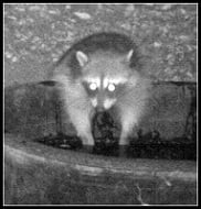
This is a mating pair. The smaller one is the female of course. The male is the one that stretches and walks away at the end. (two words...fuzzy dice)
So cool!!!!!
Ah - the two photos are of a bobcat though....

Yeah, plus that male totally looks like a tom. Excellent video!cougarmagic wrote: ↑This is a mating pair. The smaller one is the female of course. The male is the one that stretches and walks away at the end. (two words...fuzzy dice)


....The U.S. Forest Service proposes eliminating fees for three-quarters of the forest areas where they are now imposed, including 19 in Southern California....Many trail heads, day-use sites and general forest areas where fees are now in effect in the region's four national forests will become free, said Tamara Wilton, a California Forest Service manager.....The Forest Service launched a national review of the fee program last year. Regional offices drew up a list of proposed changes that will be released to the public in the next few months and submitted them to an advisory committee representing recreation interests, said Frances Enkoji, a manager in the agency's California office. The revisions would probably take effect next year.
Twenty-five fee areas would remain nationally, including 12 in the Southland. The agency plans to retain the Adventure Pass. In many areas where fees are eliminated, the agency proposes to continue charging for use of certain busy sites that are equipped with six specific amenities outlined in the 2004 law. Those include toilets, interpretive signs, trash cans and picnic tables.
That may spark more legal battles. What if you park at one of the fee sites to go hiking but don't use any of the facilities? Do you have to pay? "Yep, right now, that's the way we are managing the program and the way we are interpreting" the law, Wilton said...."
SGV board backs completion of Highway 39 to Wrightwood
http://www.whittierdailynews.com/ci_199 ... z1nv3A32Bv4 rescued from Eaton Canyon on February 21, 2012The San Gabriel Valley Council of Governments voted unanimously last week to oppose Caltrans' abandonment of 27 miles of Highway 39 from Azusa to Crystal Lake.
The local joint powers agency also voted to write a letter requesting the state transportation agency continue the project it started in 2009 to repair a 4.4-mile gap in the the state highway between Islip Saddle and Wrightwood at Angeles Crest Highway. That upper portion of State Route 39 has been closed to the public since 1978 due to a mud slide that damaged the roadway.
The COG, a collaboration of 31 cities, three county supervisors and three water agencies, addresses issues that affect the entire San Gabriel Valley and give the region a greater voice in federal, state and county government.
It is the first time the agency has weighed in on the Highway 39 issue since this newspaper reported in October Caltrans' decision to drop the roadway completion project. In December, this newspaper reported Caltrans said it could no longer afford to maintain the mountain portion of State Route 39, citing budgetary reasons, and said it was shopping the highway to other governmental entities.
It costs Caltrans about $1.6 million a year to upkeep the road, which connects county flood control workers to three key mountain dams, as well as millions of visitors to recreation areas that are part of the 650,000-acre Angeles National Forest.
A group of business leaders, cabin owners and some
environmental groups support re-opening Highway 39 as a continuous loop from Azusa and Glendora through the forest, to ski areas in Wrightwood, as well as destinations to the west in La Canada Flintridge. They contend the 34-year closure acts like a clog in the state route system, keeping visitors congregating along the west and east forks of the San Gabriel River, instead of allowing them to circulate more freely in the forest and beyond.
Barret Wetherby, a proponent of re-opening the road, called the COG action "great."
"I think that will help," he said.
Wetherby and members of the Azusa Chamber of Commerce met with state Sen. Edward Hernandez, D-West Covina, on Jan. 27, to talk about the issue. Also at the meeting were officials from Caltrans and the state Department of Fish and Game. Another meeting is set with Sen. Hernandez on March 9, Wetherby said.
At that meeting, the Department of Fish and Game will discuss whether reopening the roadway will cause harm to the San Gabriel Mountains Big Horn Nelson Sheep. Caltrans cited concern for the sheep as a reason for not pursuing the project.
Some residents of Wrightwood, however, are in agreement with Caltrans' latest decision. They say opening the road will bring too much traffic, litter and other problems from the San Gabriel Valley to the mountain resort town. Others say the mountain environment will be damaged from more cars and auto exhaust.
A two-page memo from Duarte City Councilman John Fasana, COG transportation committee chairman, notes that the re-opening project "was fully funded and was programmed in the 2008 State Highway Operation and Protection Program for $47,592,000, capital and support." Construction on the project was to begin last year.
Caltrans said in October 2011 the project was "not realistic or cost effective."
Wetherby, at the meeting with Sen. Hernandez, said he questioned Caltrans officials why an 800-foot section of Angeles Crest Highway above Pasadena was repaired in 1.5 years, while "we are still waiting more than 30 years later" for Caltrans to repair 500 feet of the 39 roadway.
When Azusa chamber officials asked what happened to the money for the project, Caltrans said they no longer had the funds.
On the issue of turning over the 27-miles of mountain highway to another entity, both the county of Los Angeles and the U.S. Forest Service have declined, according to the COG memo.
Note: Eaton canyon saw 3 rescues during that 24hrs period
http://www.amrt.org/index.php/blog/entr ... ry-21-2012Woman strikes Eaton Canyon Nature Center employee with car 2/5/12A call came out for stranded hikers in Eaton Canyon at approximately 5:30p.m. on Tuesday February 21.
By the time the first unit was dispatched we were able to make contact with one of the individuals on their mobile phone. After verifying whether there were injuries and if they were safe, we were able to determine their approximate location. The information that our victims were uninjured, in a safe location and somewhere between the 2nd pitch and the top of the falls was relayed to our field crews. The victims were updated with an occasional text, letting them know crews were on the way. A short time later the field crews made contact with the victims. The victims were located on the north side of the ridge, with two of the four over the side of the ridgeline on a ledge.Two team members proceeded up the ridgeline to set hand lines and raise two of the victims from the ledge to the ridge. The other team members remained on the canyon floor, including the crew chief, to run the operation from below.
Once in place, the hand lines allowed team members to escort the victims from the ridgeline to the canyon floor safely
http://abclocal.go.com/kabc/story?secti ... id=8531990Rancho Cucamonga stepping up trespassing enforcement at Cucamonga CanyonA dispute over a dog leash at Eaton Canyon Nature Center ended with a county park employee in the hospital.Sheriff's officials said it all started when the park employee asked a 28-year-old woman to put a leash on her dog on Friday.According to deputies, the employee asked Arune Kavaliauskaite three times to put a leash on her dog.Officials said Kavaliauskaite became angry, got into her car and then purposefully drove into the employee, knocking her into a parked car.Kavaliauskaite was arrested for assault with a deadly weapon. She's being held on $30,000 bail.
http://www.dailybulletin.com/news/ci_19 ... z1nv51ioqY
"RANCHO CUCAMONGA -- The city is stepping up enforcement against trespassers on their way to Cucamonga Canyon, the area north of Alta Loma marked by cliffs and waterfalls.There is only one legal way to enter this popular canyon -- through Big Tree Road, also known as Cucamonga Truck Trail. But many canyon visitors take short cuts through private property north of Turquoise Avenue or through the residential development west of Skyline Road.At a special meeting with the City Council and Cucamonga Valley Water District board on Tuesday, law enforcement officials said "no trespassing" signs will soon be posted and violators will be cited.San Bernardino County sheriff's Lt. Steve Smith said trespassers will be cited using the state Penal Code and prosecuted through the District Attorney's Office...."We may even film people being cited and post it on Facebook," Smith said.A public meeting on the issues of Cucamonga Canyon will take place at Stork Elementary on March 12 at 6:30 p.m."
Car plummets 600 feet on Angeles Crest Highway 2/28/12
http://maraudernews.blogspot.com/2012/0 ... geles.htmlLongboarding on the GMR: videoEarly Tuesday morning, a grey Nissan Altima went careening off a cliff on Angeles Crest Highway.The unidentified driver was on his way to work in La Cañada Flintridge when the accident occurred. George Beltram, an employee of Pro Traffic Services, was the one who walked down the hill and called the incident in. He said the car fell 600 feet. “He was all the way down there.” Another eyewitness, who works for Par Electrical Contractors, said that cars continued to speed at “70 or 80 miles an hour” even after seeing the accident before. The car was flipped, with its roof crushed, trapping the driver inside. Members of the US Forest Service, LA County Fire Department 130 and the Department of Public Works arrived on the scene. The roof of the car was sawed off and the driver was eventually airlifted to Antelope Valley Hospital. Despite the fall, he remained conscious through the ordeal.
Angeles Crest Highway remained closed for over two hours as the wreckage was removed
http://www.sunnysidelongboarding.net/20 ... n-lookout/
or a more "professional" look at the sport at non- San Gabriel locales(thanks to glendoramountainroad.com)
Water worries again....
Worries mount for Sierra, water supply
http://www.recordnet.com/apps/pbcs.dll/ ... /203010329
"Stockton remains in danger of having its driest winter since 1975-76, depending on what March and April have to offer.
"It ain't over yet," said walnut farmer Tom McGurk, whose orchards may not have the soil moisture they need this summer if Mother Nature does not deliver. Stagnant, dry weather quadrupled the number of no-burn days in San Joaquin County this winter, from 7 days last winter to 29 days this winter, the San Joaquin Valley Air Pollution Control District reported Wednesday. Inspectors wrote 88 citations for local residents who burned on no-burn days, compared with nine citations last winter. The restrictions are now over until next fall.
In 20 years of farming east of Linden, the least amount of rain McGurk ever got was 10 inches. The most was 21 inches.Right now he is at 4.5 inches, with time running out....There is still enough water stored in reservoirs to get Stockton through summer, but then we would have little left for the following year...."
O/T: Project YosemiteMontrose Search and Rescue Team members responded to a call of 12 stranded hikers at 11:08 a.m. this morning. The hikers started out of Chantry Flats earlier today, despite the impending storm, hoping to reach Mount Wilson.
“Four or five of the hikers got back to their car. The others were found and are being transported,” said CV Sheriff’s Station watch commander Lt. Debra Herman. They were found at 12:45 p.m. and were transported to their cars at the Chantry Flats area by the Montrose Search and Rescue Team and sheriff’s department vehicles.
In an interview on Friday, both MSR Team member Mike Leum and David Sweet, meteorologist with the National Weather Service, advised that no one go out into the storm if travel was not necessary.
The rain is predicted to continue throughout the day with snow levels dropping as low as 2,000 feet.

Sierra Madre rescue log for MarchAfter a busy season of injuries and rescues near Eaton Canyon Falls and other trails in the San Gabriel Mountains, local public safety agencies are hosting a press conference Tuesday to explain the dangers of the area and offer safety tips.
Representatives of the U.S. Forest Service, Pasadena Fire Department and Los Angeles County Fire, Sheriff’s and Public Works departments will be present.
The event takes place at 3 p.m. Tuesday 4/17/12 at the Eaton Canyon Park and Nature Center, 1750 N. Altadena Dr. Pasadena.


Somewhat typical news coverage of the San Gabriels on the internet-A 53-year-old man with diabetes suffered a possible punctured lung Saturday when he fell into a ravine while hiking with his family in Eaton Canyon above Pasadena, authorities said.
According to the Pasadena Fire Department, the man tumbled off the side of a canyon and into the ravine, making it difficult for a search and rescue team to find him.
Firefighters said they were notified about the fall at 10:40 a.m. Rescuers found the hiker about 50 minutes later. Authorities, who at first reported that the hiker was a teenager, said the injured man was able to talk to dispatchers on his cellphone, which helped guide searchers to his location.
Yes, the canyon is a high priority first descent that will be perfect for the fall season with plenty of red color
Sheriff's personnel rescued two rock climbers Tuesday evening in Mt. Baldy after they became stuck on a near-vertical rock face about 200 feet from the bottom of a canyon. San Bernardino County sheriff's dispatchers received a call at 6:13 p.m. from someone who heard a pair of climbers scream in the Ice House Canyon area. The caller thought the pair might be injured. Deputies in a helicopter found Andrew Clyde Ealum, 21, of Defuniak Springs, Fla. and Delley Marie Monahan, 32, of Rancho Cucamonga in about 20 minutes. Sheriff's officials said they were clinging to a shrub on the rock face and needed to be rescued. Using a hoist and night-vision goggles, deputies were able to hoist both victims out of the canyon. Officials said they were both in good health and declined medical treatment
Yet another "I wonder if..." mystery solved.AW wrote: ↑blog: canyoncartography.com
Chantry Flats to Mt. Wilson X-Country via the Winter Creek
http://www.canyoncartography.com/chantr ... ter-creek/
Trip report of MtWilson via Winter Creek(starting from upstream of Hoegees camp). No rappels or waterfalls noted.
Yup, but the San Gabriels are getting a lot smaller in that regard.
And this also reported...ANGELES NATIONAL FOREST - A man's body was found by a motorist in the Angeles National Forest at 4:35 a.m. on Wednesday.
Los Angeles County Sheriff's Department deputies responded to a call about the body found 3 1/2 miles north of city limits in Azusa Canyon.
A person driving along the canyon saw someone lying on the side of the road and thought they were dead, sheriff's officials said.
"There was no immediate sign of foul play, but there are some indications of a suicide," Lt. Andy Berg said.
The body found is described as male; no further details are available.
Homicide and coroner are currently investigating at the scene.
Memorial Signs for LACoFD Fallen Firefighters on Antelope Valley Freeway (SR-14) near Lancaster 9/20/12AZUSA - A man was discovered hanging from a tree near the riverbed Wednesday(9/19/12) night.
Azusa Police Sgt. John Madaloni said a hiker who was in the riverbed adjacent to the 1900 block of Azusa Avenue/San Gabriel Canyon Road reported finding the body. Police were notified at 6:43 p.m.
"Initial investigation by officers and detectives revealed there was no evidence of foul play. And it appears to be a suicide," Madaloni said.
Note: Actually, the Angeles Forest highway was supposed to be named after the firefighters as covered in misc news some time ago. At least there is a conclusion to this.Yesterday, a Caltrans Sign Crew from the Mission Hills Maintenance Station installed memorial signs on the northbound and southbound Antelope Valley Freeway (SR-14) for two of the Los Angeles County Fire Department’s fallen firefighters, Captain Ted Hall and Engineer Arnie Quinones.
Hall and Quinones were killed in line of duty while battling the Station Fire in August 2009 in the Angeles National Forest. The Station Fire was the largest fire in LA County history.
This sign was originally requested by Los Angeles County Supervisor Michael D. Antonovich, and the California State Legislature has designated the SR-14/SR-138 Interchange as the Los Angeles County Fire Captain Ted Hall & Engineer Arnie Quinones Memorial Interchange.

updated...
AZUSA - A man discovered hanging from a tree near a riverbed earlier this week killed himself, authorities said.
An autopsy was conducted Friday on the body of the 45-year-old Arcadia man and coroner's officials ruled the death a suicide.
Azusa police said a hiker discovered the body near the 1900 block of Azusa Avenue/San Gabriel Canyon Road at 6:43 p.m. Wednesday.
It was the second body found hanging from a tree that day.
At 4:35 a.m., a driver spotted a body of a man by mile marker 21.91 at Highway 39 in the Angeles National Forest.
Initial information from the sheriff's department erroneously said the driver saw someone lying on the road.
Sheriff's Lt. David Vega said the body was hanging from a tree.
The Los Angeles County Department of Coroner identified the man as a 25-year-old El Monte resident. An autopsy is pending.
The two cases are not linked, according to Coroner's Lt. David Smith.