
SNOW - Questions, Forecasts & Reports About Snow

-
zZClintEastwoodZz

- Posts: 9
- Joined: Fri Oct 02, 2015 4:14 pm


So whats open this weekend? Pretty much nothing west of Mount Baldy.
Hwy 2 "chains required" at La Canada
Hwy 39 closed at East Fork Road...Bridge to Nowhere trail closed anyway
Big Tujunga road et al closed.
Sierra Madre closed
High Desert closed
Hwy 2 "chains required" at La Canada
Hwy 39 closed at East Fork Road...Bridge to Nowhere trail closed anyway
Big Tujunga road et al closed.
Sierra Madre closed
High Desert closed
-
Shangri-LA
- Posts: 24
- Joined: Sun Nov 15, 2015 2:27 pm
What do you mean about Bridge to nowhere trail? I went a short distance on the EF trailhead today and I didn't see anything indicating it was closed.
It is strange that the sign at the mouth of the canyon in Azusa says that rd is open to Crystal Lake when it is not. Caltrans doesn't seem to have any idea when 39 will be open.
I was requoting the news & events section of the ANF website....Shangri-LA wrote: ↑ What do you mean about Bridge to nowhere trail? I went a short distance on the EF trailhead today and I didn't see anything indicating it was closed.
http://www.fs.usda.gov/detail/angeles/n ... EPRD488244
"Rowher Flats and Drinkwater Off Highway Vehicle (OHV) areas are closed. The South Fork, Big Rock, Gould Mesa, and Coldbrook campgrounds along with the Bridge to Nowhere Trail are closed until the storms pass. Additional closures may be implemented at any time based on storm impacts. Staff will assess the conditions following the storms and decide then whether these areas can be reopened for weekend use."
Of course under the individual pages, they are all open....maybe the EF will be open Saturday and then closed Sunday(since rain is expected Sat night)...its just they make it so unpredictable on when something will be open or not with this nanny state mentality of the new landgrabbers.

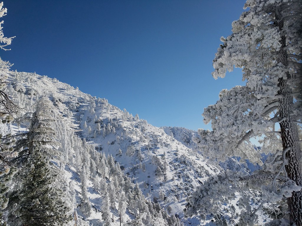
From looking at the zone area forecast for Baldy from tonight through Saturday evening it looks like there could be a total of 10-20 inches of new snow at the top, and 6-12 inches at Manker Flat. Might head up early Sunday morning with some spiky winter accouterments and see if I can make it to the top.Sean wrote: Fresh powder on Baldy. Go get some before it melts!
-
headsizeburrito

- Posts: 279
- Joined: Wed Nov 15, 2017 1:18 pm
I had a half day on Wednesday and did a short trip partway up Baldy from Bear Canyon (up to 7,600ft). There was a couple inches almost the whole way in the shaded areas and steady snow cover by 7k. By 7.6k it was maybe 4in with up to 12in drifts in places. With higher elevations and with the new snow since then you might want to consider snowshoes depending on how wet the snow ends up being and how it settles. When I was up there it was pretty dry and powdery above 7k, not sure if it'll stay that way but it has been consistently cold.
I did an easy trip up to Waterman today, here is the summit as of about noon.
Planning on getting a long day in on Thursday. Debating avoiding the snow and taking a shot at West Mermaid, or embracing the snow while we have it and doing Baldy...
I did an easy trip up to Waterman today, here is the summit as of about noon.
Planning on getting a long day in on Thursday. Debating avoiding the snow and taking a shot at West Mermaid, or embracing the snow while we have it and doing Baldy...
I got up early and hit the trail up Register Ridge at 6:00 this morning. About an inch or two at Manker and around 8-10 on the ground up to 8400'. Thinner where it was windblown, thicker in the drifts. Lots of rime ice...
Oh yeah, and it was a zoo when I headed down the hill at 10:00. There were still a few icy spots on the road and it snarled traffic. Traffic going up the hill was backed up all the way from Manker to just before Baldy Village @ the Buckhorn Resturant. Glad I was heading down and not up..
Oh yeah, and it was a zoo when I headed down the hill at 10:00. There were still a few icy spots on the road and it snarled traffic. Traffic going up the hill was backed up all the way from Manker to just before Baldy Village @ the Buckhorn Resturant. Glad I was heading down and not up..
-
Uncle Rico

- Posts: 1386
- Joined: Thu Mar 20, 2008 7:48 pm
Kratka Ridge yesterday. Coverage was about 6"- 8" with lots of rime ice on the trees. The ACH was crowded with folks letting their kids play in the snow roadside. It was melting quickly though. Probably be largely gone in a few days...unfortunately.
I went up the Vivian Creek trail today, but hit my turn-around time before getting to the summit. Beautiful day in the snow. Mill Creek canyon is melting out fast, but there is solid snow cover as soon as you get up into Vivian Creek canyon. I left my snowshoes in the car and didn't regret the decision. Vivian Creek and High Creek are flowing nicely. As usual, the easier place to fill a water bottle from High Creek is about 100 ft below the spot where the trail crosses the creek.

Did you have any traction devices - Microspikes, crampons instead?bcrowell wrote: ..... I left my snowshoes in the car and didn't regret the decision...
My general feeling about snowshoes is we don't get the right kind of snow for them, unless there is a huge load and you get there when it's really fresh. Other than that it always seems too icy, or at least when I've tried them. I have a pair that have moved twice with me without being used.
"Argue for your limitations and sure enough they're yours".
Donald Shimoda
Donald Shimoda
We had a second snowstorm this week, so I went up to San Gorgonio again, and got my butt kicked even more severely. My brilliant idea was to improve my chances of summitting by starting earlier, so I left home early and was able to start up trail at 6 am. This of course meant that I had arranged for myself an opportunity to break trail solo through the fresh powder. It was actually enjoyable, although strenuous, and Vivian Creek was super pretty. The willows were bowed down over the trail by the weight of the snow, which was poised on top of the slender branches like knife blades. At one point I resorted to crawling on my hands and knees through the tunnel formed by the willows. I knocked the snow off the branches before going through, which seemed like a pity because it was so pretty, but otherwise I would have been inundated with snow
Heading up the ridge above Half-Way Camp, I met a guy named Luke who was coming down from having spent the night at ca. 10,000 ft, and he described a fierce storm that had dropped several feet of fresh powder at the higher elevations. Since I had left my snowshoes in the car, this did not bode well for my goal of summitting. Luke continued down my boot track, and I continued up his.
Around 10 am, as I got up to about 8800', the sun was hitting the trees, and temperatures started going up like crazy. Pretty soon I was hiking in only a shirt, but the snow was melting off of the trees so fast that it was like being rained on. The snow got very wet, like the kind of conditions you normally see late in the afternoon, and I learned that although having snow balling on your boots in globs the size of bowling balls may not be as big deal when you're going down, it makes for very difficult progress when you're trying to go uphill. I decided to wimp out and turn around at this point, having probably made about three miles in four hours.
On the way down, I said hello to a lot of bedraggled hikers who had been tree-rained on. The happiest one I met was a yellow labrador retriever, who didn't seem to mind that he was soaked to the skin.
The crazy-fast melt-out of all this fresh snow, hours after it fell, was like nothing I'd ever seen before, so I don't know what to predict about snow conditions this weekend.
Do you mean the snow on the ground was melting fast, or just the stuff in the trees?bcrowell wrote:The crazy-fast melt-out of all this fresh snow, hours after it fell, was like nothing I'd ever seen before, so I don't know what to predict about snow conditions this weekend.
-
VermillionPearlGirl
- Posts: 239
- Joined: Wed Apr 06, 2011 9:57 am
Hey! Is there any snow between Little Jimmy and Windy Gap right now? (I am actually trying to avoid snow....) I'm going to try to sneak a hike in tomorrow morning before the rain/snow comes. Maybe to Hawkins. But I can go the long way from Crystal Lake (which is pretty dry guguy now, was there last week) if the North side is snowy.
-
VermillionPearlGirl
- Posts: 239
- Joined: Wed Apr 06, 2011 9:57 am
There definitely was btw  I had to put on spikes almost immediately after I got out of the car and I saw many hikers without appropriate gear turning around. And this was before the extra snow over the weekend.
-
VermillionPearlGirl
- Posts: 239
- Joined: Wed Apr 06, 2011 9:57 am
Hey, it's me, always trying to avoid snow I've seen some trip reports on the tall mountains lately where people seem to still have spikes on. Any idea what elevation the snow line is at these days? (Obviously it'll vary North/South face of the mountains). Just looking for a vague estimate. How high can I go before hitting snow right now?
Last weekend, the north side of Tahquitz Rock had snow visible on some ledges, elevation probably ca. 7000-7500'. For south-facing slopes, I'm guessing maybe 9000' right now, just as a ballpark figure.VermillionPearlGirl wrote: Hey, it's me, always trying to avoid snow
-
VermillionPearlGirl
- Posts: 239
- Joined: Wed Apr 06, 2011 9:57 am
That certainly tracks with what I can see from the ground. Thanks for the info!

-
VermillionPearlGirl
- Posts: 239
- Joined: Wed Apr 06, 2011 9:57 am
I feel like this whole thread is me popping in asking how I can avoid snow
Are the big mountains clear enough these days? Anyone been around the Islip/Throop/Burnham area?
Are the big mountains clear enough these days? Anyone been around the Islip/Throop/Burnham area?
As long as you're not trying to score some snow, you're good.VermillionPearlGirl wrote: I feel like this whole thread is me popping in asking how I can avoid snow
Rico just reported on conditions from Islip. It looks clear. Check out post #18 in this thread.Are the big mountains clear enough these days? Anyone been around the Islip/Throop/Burnham area?
-
VermillionPearlGirl
- Posts: 239
- Joined: Wed Apr 06, 2011 9:57 am
Ah I checked the TRs for updates, but this one was hidden! Thank you!