Since it was National Park Week and also the tail end of spring break, not one campsite was available inside the park. That didn't bother me too much since I was planning on camping on National Forest land outside, during some reading prior to the trip a few people had mentioned good spots nearby. However, since it takes approximately forever plus a couple hours to get there, it was dark by the time I reached Forest Road 688 - but I got lucky in finding a flat spot pretty near the highway junction. These are popular with RV's, however most spots I saw didn't have too much level ground for pitching a tent. Didn't matter too much since I set my alarm for 4:20am, planning on enough time to have some breakfast, break camp, drive to the Visitor Center and catch a bus to the SK trailhead. That all worked out great, after cleaning some frost off my windshield I drove in and parked at 5:55 and walked 100 yards to the VC where I caught the 6:00 bus. Just 10 minutes later I was chatting with a backpacker at the trailhead, who asked me if the trail was easy to follow.....He had waited three days to get a permit and didn't want to miss anything. I think maybe during that time he could have read about it or checked a map.
The trail switchbacks down right away, and in the shady part of the canyon it was a morning suited to long pants, long sleeves and gloves. I shed all of these while taking a long break at Cedar Ridge, which is about 1.5 miles down the trail and the point where things get much sunnier. After that, it's just more and more downhill, with a short detour to the actual Skeleton Point where the cliff edge provides a great east and west views. I reached the tunnel leading to Black Bridge a little over three hours after hitting the trail, at this point I waited for a church group spread out on the trail to finish their (very long) prayer time. On reaching Boat Beach at the river, there was a group of rafts tied down with folks packing up their gear. Seems some people walked down to meet the rafters there and would join them for the next two weeks of adventure. I shed my shoes, socks and gear, ate some salami and cheese tortilla wraps for lunch and also enjoyed the celebratory Golden Road beer I carried down. I also cooled off in the frigid river, wading out about thigh-depth a couple of times although not for long due to cold feet.
For the walk back up, I checked to make sure I had enough water to reach Pipe Creek, which the trail crosses four times in the first couple of miles. I refilled my Camelbak bladder there, along with a Powerade bottle to ensure I would have enough water. The temperature at the bottom of the canyon was supposed to reach about 94 degrees this day so it was plenty warm. Once past Pipe Creek, the trail starts to climb quite a bit, so the near term goal is to reach Indian Garden which at 4.5 miles is about halfway up the Bright Angel trail. At this point I was still making pretty good time, reaching this milestone about 20 minutes earlier than I had figured. One drawback now is that one of the giant cottonwoods here is now in cut pieces, meaning a lot less shade. I did stop for a while to do some more eating, along with refilling my bottle of water with Gatorade mix. The thermometer was just nosing close to 100 in mixed sunlight as I left IG, unfortunately the rest of the hike is almost directly south or into the mid-day sun. From here to the rim there are two rest-houses, at 3 miles and 1.5 miles which meant that I could plan for just three separate 1.5 mile hikes. Sounds easy....I figured by now I might be doing about 1.5mph, meaning an hour for each one. So I was pleasantly surprised when I reached the 3-mile house after 45 minutes, although it was a bit tiring as I got closer and the shady break was nice. Then I made it to the 1.5-mile stop in less than an hour, although I stopped for uh, photo opportunities a lot more. From there it was just a slog back up the last 1.5 miles, I was very tired and like always figured I should get myself into better shape before I attempt things like this. However, once I saw the rock tunnel below the rim I found a little spring in my step and reached the end point after about 9:40 total time on the trail.
Trying to break this down into 10 pictures:
View from the the first 100 feet of trail
Reaching Cedar Ridge, where the trail really opens up into the canyon
Almost to Skeleton Point, the trail follows along that ridge and then switchbacks down quickly
Arriving at Boat Beach, I walked over and sat down in the shade for almost an hour
Looking back at Silver Bridge after crossing the river
Time to leave Indian Garden, halfway up Bright Angel trail
Looking back down just after leaving 3-mile rest house, IG is the lower group of trees
Almost to the top - I like how some of the trail looks like it is going into nowhere
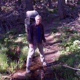
Tourist photo from the rim, after my break which included drinking two full bottles of water
AllTrails track of the route, I missed about a half mile when I left the river. The last 1.5 miles took over an hour to walk.
It's a great hike, although probably too hot from now until October or so......