
Bobcat Fire: closure info, what's open


-
Uncle Rico

- Posts: 1386
- Joined: Thu Mar 20, 2008 7:48 pm
Seems like the ANF is being deliberately vague about status. The LPNF has announced on its landing page that it is mostly back open effective today.
Until they issue a document like this but for the bobcat fire https://www.fs.usda.gov/Internet/FSE_DO ... 780808.pdf everythings technically open. Might be the only window of opportunity to go into certain areas for a while. Edit they said on twitter they're releasing the map later today. Edi2: they released it https://www.fs.usda.gov/Internet/FSE_DO ... 822448.pdf
-
ReFreshing

- Posts: 66
- Joined: Mon Nov 26, 2018 1:00 pm
Right? lolol Can't see any details whatsoever. Found a better map:Slowest_Hiker wrote: ↑Another quality ANF closure map. ?
-
stonehillnews
- Posts: 72
- Joined: Thu Dec 15, 2016 1:31 pm
I transcribed the legal description from closure order into CalTopo. Please note any mistakes you may find so we can make it accurate.
https://caltopo.com/m/9KEQ
I made a tiny url for it too https://tinyurl.com/bobcat-closure
I plan on adding the specific trail and road closures as red lines, eventually.
NB: I'm virtually certain there are a couple of typos in the legal description. The order refers to sections 34 and 33 where I believe it should say 54 and 53.
Another plausible explanation is that the data on the CalTopo layer is wrong. In either case, it's impossible to draw the line as described in the order without transposing 34 to 54 and 33 to 53.
-
- Excerpt of CalTopo Map
-
- Excerpt of Closure Order Legal Description
-
stonehillnews
- Posts: 72
- Joined: Thu Dec 15, 2016 1:31 pm
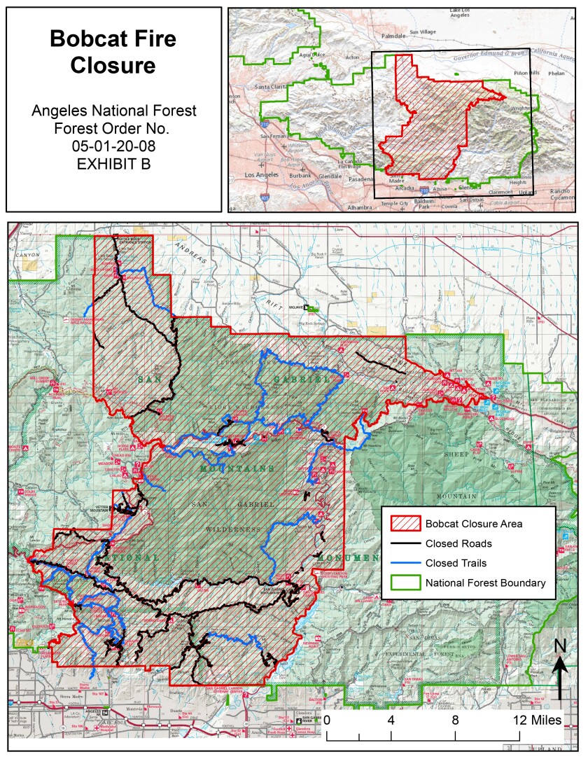
It looks like this map contradicts the one in the official closure order that was circulated. See NE corner of the boundary.
Right? lolol Can't see any details whatsoever. Found a better map:
-
- Contradictory map
-
- Map included in the official order
-
Tom Kenney

- Posts: 351
- Joined: Sat Sep 29, 2007 7:51 pm
If one was in need of bagging Iron/Rabbit/Roundtop for some reason (list completionist?), now would probably be a good time. The 3N17 was open from Mill Creek to Three Points yesterday. There were lots of hunters everywhere. Somebody was exiting the Gleason seg of 3N17. Does the USFS give out the code for that like they do for Rincon?
Yesterday, I visited Horse Flats Campground via pacifico mountain road to try and boulder! All the gates were open and the road has been smoothed out probably from the fire trucks. There were a few flare ups around wilson and cogswell but other than that, the skies were clear and beautiful! I believe the road to chilao from pacifico is open as well if you want to visit there.
I took some 35mm from the trip so i'll make sure to share those photos when I get them developed
I took some 35mm from the trip so i'll make sure to share those photos when I get them developed
-
stonehillnews
- Posts: 72
- Joined: Thu Dec 15, 2016 1:31 pm
I've more or less finished adding the trail and road closure layers from the FS Bobcat Closure order. There is some pretty obscure stuff on there, like "Pine Hollow Picnic Area Road (3N91)" which I think I found on the USGS layer by pure luck. I put a question mark after each one that involves speculation/guesswork.
There are still one road and three trails I just can't piece together from the information I've looked at so far.
Any help with finding these missing lines, as well as proof reading of what I put up there, appreciated https://caltopo.com/m/9KEQ
There are still one road and three trails I just can't piece together from the information I've looked at so far.
- Cienega Well Road (3N86)
- Wolf Tree Interpretive Trail (1311W12)
- Sierra Alta Trail (139W01)
- West Fork Trail (232N28)
Any help with finding these missing lines, as well as proof reading of what I put up there, appreciated https://caltopo.com/m/9KEQ
-
Slowest_Hiker
- Posts: 245
- Joined: Sun Jul 31, 2011 12:31 pm
Great work.
Sierra Alta trail seems to be the little nature trail at Jarvi Vista
https://goo.gl/maps/vgij7rmLHpAPHsYu5
Sierra Alta trail seems to be the little nature trail at Jarvi Vista
https://goo.gl/maps/vgij7rmLHpAPHsYu5
-
David Martin
- Posts: 85
- Joined: Sun Nov 08, 2020 7:08 pm
As part of our big San Gabriels loop my buddy and I plan to hike the PCT from Mill Creek Summit to Three Points this weekend. We've had 2 recent hikes to Mill Creek and I know all the trails are open there but I wasn't 100% sure about the Three Points side, so I drove up there with my wife today for a look.
At Three Points the northbound PCT is totally open. The eastbound side is not blocked or gated but there's a yellow sign at the trailhead warning of trail hazards caused by the fire, and a map of the closure area (crummy photo attached).
My question: I'd sure like it if there was some hike we could do heading east from Three Points. The warning sign I saw seems to say "enter at your own risk", but not "trail closed." Any ideas for some reasonable option here? I was looking at PCT from there to Cloudburst Summit and Cooper Canyon then either clockwise around Buckhorn Peak back to the highway, or north to Burkhart Saddle and then up to Devil's Punchbowl Rd. Or the Mt. Waterman trail???
Does anyone think there is any possible option in that direction...or should I just forget about it and move on to another area.
Also, what does "Congressional Boundary" on this map refer to?
The best official word is the map stonehillnews transcribed from the ANF order: https://caltopo.com/m/9KEQ
It clearly shows that E of Three Points the PCT is closed, but I have heard that some things (the road for instance) are open past where they claim. No idea what the actual conditions are. Has anybody gone up there?
It clearly shows that E of Three Points the PCT is closed, but I have heard that some things (the road for instance) are open past where they claim. No idea what the actual conditions are. Has anybody gone up there?
-
Tom Kenney
- Posts: 351
- Joined: Sat Sep 29, 2007 7:51 pm
I have no info on the trails/roads within the closure, but the Mt Wilson Road is open again.
'Congressional Boundary' is probably a reference to the National Monument designation. Funny how all the signs for the new Monument are placed 'outside' the old ANF signs, so you'll see them first/earlier?
'Congressional Boundary' is probably a reference to the National Monument designation. Funny how all the signs for the new Monument are placed 'outside' the old ANF signs, so you'll see them first/earlier?

Probably that. But if your "crazy uncle" decides to enter the closure area, please tell us about his adventure.David Martin wrote: ↑...or should I just forget about it and move on to another area.
-
David Martin
- Posts: 85
- Joined: Sun Nov 08, 2020 7:08 pm
After hiking from Mill Creek Summit to Three Points yesterday Kurt and I had a little time left, so we scouted the trailheads and highway to get more info. Here’s what I learned...
First, the eastbound 2 was open to Cedar Springs. That place isn’t shown on the Harrison Map but it’s about halfway between Buckhorn and Islip Saddle, a few hundred feet west of the 6600’ indication and the picnic table symbol. Near Buckhorn a sign states that chains are required if continuing east, but we saw several dozen cars on the road and none had them. There was no snow or ice on the roadway. (I’m not sure about the eastern side of the closure. When we hiked to the the glider 2 weeks ago it was closed at Grassy Hollow, but when we walked the closed section to Vincent Gap, it was clear.)
At Three Points we talked with a nice couple who'd hiked the area a few times since the Bobcat Fire. They said that some of their walking had been off trail, but recently they hiked the circular loop route around Buckhorn Peak and it was mostly fine. They said they didn’t encounter much fire damage, and the trails themselves were in ok shape.
Between Three Points and Cloudburst Summit the PCT parallels the 2, crossing it 4 times. So there are 8 signed trailheads along that stretch, and I gave each one a quick look. None were marked closed in any way. On the PCT north of Three Points there was a yellow warning sign like the one I’d seen south of the highway. I didn’t see any “closure” indications at all, except the map I mentioned earlier at the south PCT crossing at Three Points, and a sign near the former PCT trailhead just east of Cedar Springs stating that the trail is closed due to restoration of the frog habitat. The trail north from Buckhorn Spring didn’t appear to be closed or signed.
I take all this as a dim green light to attempt one or two more hikes through this area, and will ponder the options. Maybe the PCT sections that follow the highway and then the Buckhorn loop. Or maybe some route that includes the Little Rock fire road or the trail north that passes Burkhart saddle…those options could require a long car shuttle but I’m very interested in walking through the “Pleasant View” area to the north, if it’s possible. (I would not enter the frog habitat.) Maybe I can find some recent trip reports on Strava or AllTrails. If anyone has a suggestion please let me know, and if we do continue out that way I’ll post a trip report.
In the end I’d like to keep walking all the way to Vincent Gap somehow, ideally via Baden-Powell. If the only way through is the 2 in some places we can do that on foot or by bike; so be it.
Are there any maps that accurately show the areas of actual fire damage, and maybe the severity of it?

-
David Martin
- Posts: 85
- Joined: Sun Nov 08, 2020 7:08 pm
I hope to bring my MTB up to that section in the next week or two to give it a try. I want to get a better idea of the burn damage and see what hikes might be do-able around there. Maybe next Tuesday, to beat the new snow that’s forecast for Weds/Thurs.
When we hiked to the glider last month the 2 was closed at Grassy Hollow, a few miles east of Vincent Gap. That’s still the case, according to roads.dot.ca.gov/, so you’d probably have to start riding from there.
The other end of the closure is at Cedar Springs, so there's 16 miles of closed road between the two gates. I wonder if some of this is due to fire damage. Has part of the 2 been closed ever since the Bobcat Fire?
I’ve been up to to the Cedar Springs area 4 times in the last couple weeks including a 12 mile hike yesterday east of Three Points. (Everything was about half-burned. The trails showed some evidence of recent repairs and were easily walkable. There were no closure signs or barriers. Saw a few other hikers, mostly near the trailheads. https://www.strava.com/activities/4903702379)
I’ve seen no LEO’s up there. I think I’m more concerned about slipping on ice or being unable to get through than getting a ticket or a lecture.
-
Tom Kenney
- Posts: 351
- Joined: Sat Sep 29, 2007 7:51 pm
According to the CalTrans Map, the CA-2 closure has been dialed back to Eagle's Roost.
NVM...seems it was mentioned above.
NVM...seems it was mentioned above.
-
David Martin
- Posts: 85
- Joined: Sun Nov 08, 2020 7:08 pm
As of yesterday the western side is still gated about 1000 feet before Eagles Roost, as it has been for at least a month.
The eastern side had been gated at Grassy Hollow, but that gate is open now and the closure is at Vincent Gap.
I've seen and walked most of the pavement in between, and it's almost all clear. Just a few minor rockslides, mostly near the tunnels. There are one or two spots near Dawson Saddle where ice and snow cover the eastbound lane. No fallen trees on the roadway or pavement damage, no slides worth mentioning. It looks like that whole closed section could be re-opened without much clean up effort, and maybe that will happen in the next few weeks.
West of Dawson Saddle some areas are burned but others look fine; it's hit and miss. East of Dawson it all looks great.
-
Uncle Rico
- Posts: 1386
- Joined: Thu Mar 20, 2008 7:48 pm
Bobcat Fire closure order set to expire April 1.
Anybody hear that the FS intends to extend it further? Being the good, law-abiding citizen that I am, I want to make sure I don't violate the order. That would cause me terrible distress.
Anybody hear that the FS intends to extend it further? Being the good, law-abiding citizen that I am, I want to make sure I don't violate the order. That would cause me terrible distress.
Who are you kidding? Your feelings don't matter.Uncle Rico wrote: ↑Bobcat Fire closure order set to expire April 1.
Anybody hear that the FS intends to extend it further? Being the good, law-abiding citizen that I am, I want to make sure I don't violate the order. That would cause me terrible distress.

A call yesterday indicated that 04.01 remains good. The discussion did include that this was not being advertised too aggressively for fear that certain areas such as the WF San Gabriel River will get overrun by the BBQ and dirty diaper masses. I am all for public use - simply not public abuse. I intend to call again towards the end of March to be sure of the 04.01 date.Uncle Rico wrote: ↑Bobcat Fire closure order set to expire April 1.
Anybody hear that the FS intends to extend it further? Being the good, law-abiding citizen that I am, I want to make sure I don't violate the order. That would cause me terrible distress.
Im getting my daipers ready.
I too would feel distress if i happened to cover ground closed to the regulars. I might have to take my spark-emitting shoes and leave my suit made of matches and gasoline at home this time as well.
And my feelings also dont matter. Much happier that way, strangely enough.
But furreal, looking forward to riding Rincon.