
Kurt and I had planned to hike from the Aliso Canyon Rd. / power line road junction to Mill Creek Summit but road closures and icy conditions put the kibosh on that, so I planned an alternate route from Vasquez Rocks up to Bouquet Canyon. I hadn’t given much thought to that area before, but since we’d already walked from Kurt’s house in Glendale to Vasquez Rocks, it seemed like a good spur route. We’d be able to look north back towards the Magic Mountain Wilderness, and hopefully see some of the firebreaks and peaks that we’d hiked in recent weeks.
After driving for 2 hours and leaving a shuttle car at Bouquet Canyon Rd., we started north from the Park a few minutes before 6, with the temperature just above freezing. The PCT has a gap here, so we took side streets and Agua Dulce Canyon Rd. 3 miles to Peterson Rd., where it resumes. That section isn’t very interesting, but approaching the trailhead we were surprised to see a large passenger plane fuselage affixed to the ground, to our left. (It turns out that the L10-11 fuselage is part of the Agua Dulce Movie Ranch and is used for interior shots.) At Peterson Rd. the first PCT sign sent us up a fire road; a half mile later the trail proper began on the left, climbing towards the snow covered ridge.
The going was very pleasant; sun rose over the hills and warmed us. But after crossing a creek bed and bending northeast, a sad sight was revealed — a large burn zone lay ahead. After a few more bends in the trail, all was rock and ash, with no live vegetation. I’d never hiked through a recently burned area, and being amidst all that devastation was shocking. Everything was rocky and burned, with no green except some small tufts of grass. The air had a terrible sour odor, like a doused campfire, but much stronger. Flocks of birds of prey noisily patrolled overhead. Maybe the lack of ground cover made for good hunting. The PCT was narrow and looked like it had been re-graded recently — more of a line through the dirt and rocks than a trail.
On the plus side, we had excellent views of Magic Mountain summit, two of the long firebreaks we’d climbed out there, High Point, and the Santa Clara Divide.
(After getting home I tried to figure out what this fire this was, and when it happened. There have been many fires near Agua Dulce, but it might have been this one from July of last year.) We could hardly wait to get out, and after crossing a firebreak it was suddenly behind us.
At about 3600’, we began climbing through patches of fresh snow. At the ridgeline, PCT makes a hairpin turn east and climbs up. We followed a short, steeper firebreak up to the left to have views in both directions and weren’t disappointed. From the small bump at about 4690’ we could see the Gorman area and Sespe Wilderness, parts of Palmdale, and the High Desert, due north.
From the ridge, PCT zigzags down to Bouquet Canyon Rd., through some beautiful forest. Since it’s northern slope there was much more white stuff and this was very nice walking, crunching through snow while enveloped by greenery, with Bouquet Reservoir in the distance.
We reached our shuttle car just after 1, about 7 hours after starting. It was 12.5 miles, 2443’ of climb: https://www.strava.com/activities/4707764856. We encountered about 20 runners and hikers. This was a very enjoyable, almost-all-weather option to the San Gabriels hikes we’ve been doing, and it was nice to experience some trees and greenery after all those mean looking, barren slopes of the Magic Mountain Wilderness.
The next 30 or 40 miles of PCT look promising for future day hikes, with good access from paved and fire roads past Sawmill and Bear Mountains, and ultimately Lancaster Road. It'd require a lot of driving, but we don't really mind much, and may continue northwest through these sections on and off over the next few months. If so, I’ll follow up here.
Heading North on the PCT from Vasquez Rocks
-
David Martin
- Posts: 85
- Joined: Sun Nov 08, 2020 7:08 pm
-
- Heading down to Bouquet Canyon Rd., with Bouquet Reservoir to the west
-
-
- Descending from the ridge
-
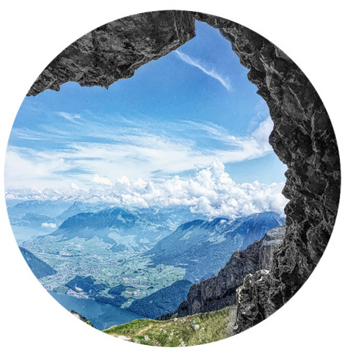
- Panorama from the summit
-
- This firebreak marked the end of the burn zone
-
- All in this section was burned and dead
-
- Morning breaks over the summit ahead of us
-
- The Agua Dulce Movie Ranch
-
-
David Martin
- Posts: 85
- Joined: Sun Nov 08, 2020 7:08 pm
Kurt and have been continuing north through these hills so I thought I’d amend this thread. Our hikes have mainly just followed the PCT so there’s no breaking news, and I'll keep these entries short. But there are some great views and I enjoyed seeing the area, which has mostly been new to me.
We continued on the PCH from Bouquet Canyon to San Francisquito Canyon on March 13. This was a very nice 14 mile section of trail with about 1700’ of climb. The first few miles, which make for a good uphill workout, are followed by a lot of up and down stuff.
About 2 hours in, I mentioned to Kurt that despite doing 5 or 6 PCT hikes and seeing several dozen walkers and runners along the way, we hadn’t come across any long distance hikers. After watching Wild, I guess I expected to encounter some at times but so far it had been just plain old day hikers, like us.
Less than a half hour later while taking a short break at a bend in the trail, a pair of older gentlemen came around the corner. From the looks of their gear it was obvious that they weren’t day people and of course we got to talking. It turned out they'd started at Walker Pass, near Lake Isabella, and were headed to the PCT’s southern terminus at Campo. These fellows were long time friends and had logged thousands of miles together on the Appalachian Trail and other long distance hikes. Great guys.
Towards the end I rounded a turn and found myself looking at a beautifully set up rest spot. There was a huge solid bench bench shaded by beautiful old trees and a large sign honoring winners of the Leona Divide 50. Man, it felt good to lie down and rest on that bench. Dangerously good! But after enjoying that spot for a while we figured we’d better move on knock out the final climb.
Overall this area was very scenic. There was a little fire damage, which looked old, but the hills were healthy and beautiful. There’s no water along the way and no restrooms or parking lots at either trailhead, but the shoulders have plenty of space for cars.
-
- I Wonder Who Made These prints?
-
- Our First Trail Log
-
-
- A Very Dangerous Place
-
-
-
-
- The Long Distance Dudes

-
David Martin
- Posts: 85
- Joined: Sun Nov 08, 2020 7:08 pm
Damn, I didn’t know that! You think some gummies would've been ok?
For the next PCT segment we walked from San Francisquito Rd. to Lake Hughes Rd. We turned right at the road, then right again at Lake Elizabeth Rd., and walked into town. I'd noticed a place called The Rock Inn in Lake Hughes, which looked like a nice old place, and when I called they said they’d be open all day, serving meals both indoors and out. That seemed like a great way to wrap up this easy hike.
The route started with a moderate, pretty climb up from San Francisquito, with good views that improved as we approached the saddle at 4275’. From the top, which is a really nice spot, we could see a lot of the high desert, several wind turbine farms, a solar installation, and the mountains in front of Tehachapi. I was a little disappointed that the aqueduct, which I’ve cycled a couple of times, was hidden from view. After the saddle it was almost all mild descent, through rolling hills with some really scenic little shady canyons, shaded by oaks.
There’s a little fire damage but overall that area’s healthy and green. It was March 20, the first day of spring, and colors were starting to emerge.
At Lake Hughes Rd. there’s a big sign showing that the PCT on the other side is open by permit only, apparently due to the Lake fire. Reading up on that later, it looks like the rest of PCT through those hills is now a no-go. I’ve seen that at Pine Canyon Rd. the PCT turns into a boring track / dirt road through the California City area, avoiding the hills, because Ft. Irwin Ranch never granted use to the trail through their property. So that might be the end of the road for my PCT hikes in that direction, though I’ve read that one section passes through a wind turbine area, which might be kind of interesting. Otherwise, from what I can tell, it's a nothingburger until you get past Tehachapi. (BTW, next time you’re there, check out Red House BBQ, It’s a great old place with excellent food, operated by a native American family.)
The Rock Inn is pretty cool, too. It’s a landmark place dating from 1929 with a large menu. It has a rustic vibe and gets a lot of biker traffic. We ate inside; the first time for me in about a year. Good burgers and the waitstaff were friendly.
Speaking of lockdowns and all, I’d had my second Moderna shot 4 days prior, and was curious to see if would affect my hiking. I’d just felt a little spacey after the first jab, but was sick as a dog the day after the second one. It was bizarre to feel perfectly healthy one day, stuck in bed feeling like a wreck with all over body aches the next day, and then normal again the day after that. Anyway my endurance seemed normal on this hike, but I had lower back pain and weird aches in my glutes that I'd never experienced before. Nothing awful, just noticeable and strange. Whatever — to me it was well worth the benefit.