
A friend suggested this loop after seeing my Strawberry hikes on Strava. It was good fun, certainly reminded us of Strawberry, and was a short drive from the house. I couldn’t find any previous discussion here so maybe it hasn’t come up on EP before.
We headed out two Saturdays ago, leaving Glendale at 0300 and started hiking a half hour later, from the end of Alpine Way in the northeast corner of Sunland. A short path took us to up the Graveyard Truck Trail (hey, I didn’t name it!) which runs between Big TJ and Mt. Lukens. We turned left towards the canyon.
Minutes later rounding a corner, we saw a fire near the wash, about 2 miles north. No firefighters were on scene and I had bars, so I stopped to call 911. The fourth person I spoke to was the right one and after telling them what I could we continued on the fire road, walking towards the fire. About 7 minutes after my call the first fire trucks arrived, then many more, then a couple of small helicopters. As we continued north, we watched them fight the fire. It became apparent that the action was near the end of our fire road, where it met the highway. We wondered if we might have to cancel and head back to the car, but a moderate wind was blowing the fire away from us, the firefighters were gaining control, and there seemed to be a lot of fuel-less land between us and the flames.
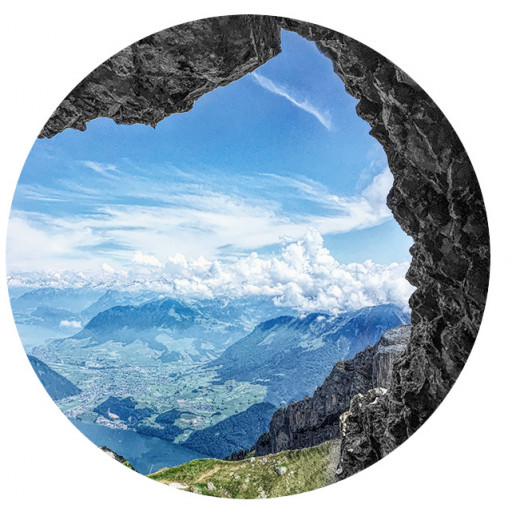
Before long we saw a tall sign that read "K E Q” and the narrow trail behind it, leading up a hillside. Canyon walls hid the fire as we climbed, but we could see that flames were going down and the smoke was dissipating. Soon we crested a ridge and began switchbacking up a steeper slope. It was now getting light and we could see the route ahead, which climbed a steep rocky ridge. The trail was always easy to follow. While similar to Strawberry, it wasn’t quite as adrenaline-inducing because the drop off weren’t as steep, but it was a hands on experience, requiring some effort. Views got better and better, then we saw a big flag on a distant, then we were beneath it in a little pocket shaded by rocks. It was clear, and the views were excellent. We could see downtown L.A., Lukens, parts of S.F. Valley, a lot of the high country peaks, and a closer peak that may have been Condor or Fox. We had lunch and enjoyed a short nap, awakened by the voices of 3 hikers approaching from the south. Our spot beneath the flagpole was very cozy but the sun was gaining strength and it was time to move on.
Heading south from the flag the path was more trail-like, but just as steep — you drop about 1600’ in just over 1.5 miles. Much of the second half is hundreds of steep steps, leading back down to the fire road. Some person or group worked hard to build this trail, and it must have taken a long time. We were grateful for the steps -- without them, it’d be a much more difficult descent. There are also funny little signs along the way and in one steep spot, a long pipe with a T handle at the top, to help with the drop. About 5.5 miles in we turned right on the fire road that we started on, which was now busy with local walkers and runners.
After getting back to the car we drove down to see the aftermath of the fire. It was in a flat area near Graveyard Road, southwest of the water tank, that might be the site of a former camp.
This was a fun and relatively short hike, close to town, with excellent views. It could be a great short-notice hike if the skies are clear and you feel like doing something different for a few hours.
About 7.5 miles, 2400' of climbing. https://www.strava.com/activities/5533697177
Tujunga Flag loop via the Kill 'Em Quick Trail and Mt. Lukens Road
-
David Martin
- Posts: 85
- Joined: Sun Nov 08, 2020 7:08 pm
-
- Aftermath of the fire.
-
- Much of the trail is very well marked.
-
-
-
- Approaching the flag, with La Crescenta and the Verdugos below. (I live in Burbank on the other side of those hills.)
-
- Final climb to the flag.
-
- Random Point.
-
- Starting up the ridge.
-
- North end of Kill 'Em Quick.
-
- The first fire trucks arrive on scene.

-
David Martin
- Posts: 85
- Joined: Sun Nov 08, 2020 7:08 pm
Yes, I think so. We headed south from the flag, but there's also a ridge route going east to Lukens from that summit.
The friend who told me about this hike sent a link to this excellent video, made by the guys who planted the flag there. It includes part of an old Woody Guthrie song about a big flood in that area:
And part 2, which actually has better views:
And this interesting one, that explains the history of the KEQ trail, which apparently was built by inmates at the now closed fire camp on BTJ. According to yet another video from this team, juvenile detainees could only become qualified "saw men" if they made it to the top of Kill 'Em Quick within 30 minutes while carrying a chain saw.
Here's another photo from my hike, which shows some of the deep steps on the south trail to Mt. Lukens Road. There are hundreds of these steps and digging them out of the hillside must have been a huge job.

-
David Martin
- Posts: 85
- Joined: Sun Nov 08, 2020 7:08 pm
⇈ ဒါကတကယ့်ကိုတိုက်ဆိုင်မှုပါ။
အကြှနျုပျ၏တုံ့ပြန်မှုအတိအကျအတူတူပင်ဖြစ်ခဲ့သည်။ ?
အကြှနျုပျ၏တုံ့ပြန်မှုအတိအကျအတူတူပင်ဖြစ်ခဲ့သည်။ ?
-
David Martin
- Posts: 85
- Joined: Sun Nov 08, 2020 7:08 pm
I guess I haven't either, though sometimes I see lengths of railroad tie used that way. Are steps like that considered harmful to the land for some reason?
Trails in the mountains of Asia sometimes have very long sections of large steep steps, often chiseled into rock and worn smooth from decades of use. It's startling to come around a corner and see some huge stairway climbing 1000' or so and disappearing into the clouds.
Trails in the mountains of Asia sometimes have very long sections of large steep steps, often chiseled into rock and worn smooth from decades of use. It's startling to come around a corner and see some huge stairway climbing 1000' or so and disappearing into the clouds.