
what is the final point, can I get close to the base of Wright Mt?
how long from the 2 does this part take, approximately?
thanks guys
another reason this forum is awesome
Blue Ridge Road (3N06)

A few years ago (timely info eh?), my accord made it no problem all the way to the start of the North Backbone Trail at the base of Wright. As Matt says, careful on the last mile or so. Don't remember how long it took but it's pretty insignificant compared to the total time it took from Pasadena (best guess is 20-30 mins max I would think).
Might want to check with locals to see if the gate at the ACH is open. Who knows what they locked during the fire closure.
Might want to check with locals to see if the gate at the ACH is open. Who knows what they locked during the fire closure.
The Cal-Trans gate is still locked on Hwy 2 at Big Pines tonight. Hopefully, Cal-Tran's/CHP/ANF will get things together tomorrow, and get it open to at least Vincent Gap. We'll get more info tomorrow, I suspect.
Once that gate is open, Blue Ridge Rd will be open all the way back down to Lupine until the snow flies/Mt. high makes snow. And yes, as stated here, you can do it in a Civic. Just take it slow the 1st 2 miles on the broken pavement, and a few points in between after that. No big deal.
Once that gate is open, Blue Ridge Rd will be open all the way back down to Lupine until the snow flies/Mt. high makes snow. And yes, as stated here, you can do it in a Civic. Just take it slow the 1st 2 miles on the broken pavement, and a few points in between after that. No big deal.


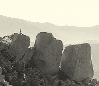
You can get to the west approach (via the PCT), the North Backbone Trailhead, or the east approach (via the PCT) using the road. Wright Mountain is super anti-climactic. There's no distinct summit.Zé wrote:what is the final point, can I get close to the base of Wright Mt?
how long from the 2 does this part take, approximately?
thanks guys
another reason this forum is awesome
A descent down Fish Creek to the East Fork, now that would be interesting. If anyone in your party lived that is.
"How far can a Civic get up Blue Ridge?"
It reminds me of "How much wood could a woodchuck chuck if a woodchuck could chuck wood?"
According to some cogent academic research about 700 lbs!
"How far can a Civic get up Blue Ridge if a Civic can go up Blue Ridge?"
Yeah I'm nuts....
It reminds me of "How much wood could a woodchuck chuck if a woodchuck could chuck wood?"
According to some cogent academic research about 700 lbs!
"How far can a Civic get up Blue Ridge if a Civic can go up Blue Ridge?"
Yeah I'm nuts....


Hey everyone-
First time poster, but long time reader
I was wondering how accessible Blue Ridge Road is? I have a Honda Civic and shudder sometimes when I see the phrase "dirt road." My goal is to summit Pine Mtn and Dawson Peak. I thought it'd be cool to try it from the north (versus summiting Baldy and then heading over to Pine and Dawson). Any ideas/suggestions/input?
-Matt
It's rather easy to follow. There's a split a bit further along...
http://www.summitpost.org/image/660283/ ... -sign.html
...that would take you to Lupine if you went right, or Wright if you went left.
http://www.summitpost.org/image/660283/ ... -sign.html
...that would take you to Lupine if you went right, or Wright if you went left.
Blue Ridge Road is easy to follow. Map. Turn off ACH at Point D.
At Guffy Campground the road splits (point C) - stay right (going left and up the hill will get you to the campground). Shortly after Guffy the road splits again (point B) - stay left (going right and down hill will get you to Lupine Campground). Continue on to the parking area (point A) for the trail to Pine/Dawson (a wide area at a bend in the road) big enough for a few cars.
The stretch of road between Guffy and the parking area will be the roughest, but at worst you'll have to get out of the car and toss a rock off to the side. If for some reason you can't make it all the way to the parking area, then park at Guffy (but not in a camp spot) and hoof it the rest of the way to the parking area (either along the road or on the signed PCT trail).
Once at the parking area for the trail to Pine/Dawson look for a trail that steeply drops down the ridge to the south that leads to Pine. It's easy to spot this trail and even easier to stay on it - just stay on the ridge.
There may be a trail sign at the saddle between Pine and Dawson, but it is for a trail that heads down to Fish Fork. No other trail signs that I recall seeing. Bring a map.
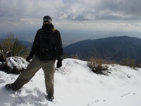
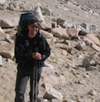
Pics from my last trip to this area.
Oh, and at this time of year you will more than likely see and/or hear hunters. Wear your antlers.
At Guffy Campground the road splits (point C) - stay right (going left and up the hill will get you to the campground). Shortly after Guffy the road splits again (point B) - stay left (going right and down hill will get you to Lupine Campground). Continue on to the parking area (point A) for the trail to Pine/Dawson (a wide area at a bend in the road) big enough for a few cars.
The stretch of road between Guffy and the parking area will be the roughest, but at worst you'll have to get out of the car and toss a rock off to the side. If for some reason you can't make it all the way to the parking area, then park at Guffy (but not in a camp spot) and hoof it the rest of the way to the parking area (either along the road or on the signed PCT trail).
Once at the parking area for the trail to Pine/Dawson look for a trail that steeply drops down the ridge to the south that leads to Pine. It's easy to spot this trail and even easier to stay on it - just stay on the ridge.
There may be a trail sign at the saddle between Pine and Dawson, but it is for a trail that heads down to Fish Fork. No other trail signs that I recall seeing. Bring a map.
Pics from my last trip to this area.
Oh, and at this time of year you will more than likely see and/or hear hunters. Wear your antlers.
Had plans to drive to Lupine Camp on Memorial Day, but the gate at Guffy was locked. Blue Ridge Road beyond that to Wright Mountain (didn't walk down road to Lupine) has just a few rocks that would need clearing but no reason to keep it closed. Frustrating.
-
Slowest_Hiker
- Posts: 245
- Joined: Sun Jul 31, 2011 12:31 pm
I saw on wrightwoodcalif.com that it's now open to Lupine. Has anyone been past Guffy -- can a regular passenger car get all the way to Lupine after this year's maintenance? I know in prior years they have recommended high clearance past Guffy. Thanks
-
Slowest_Hiker
- Posts: 245
- Joined: Sun Jul 31, 2011 12:31 pm
I can answer my own question with a pic of my Prius (!) at Lupine:
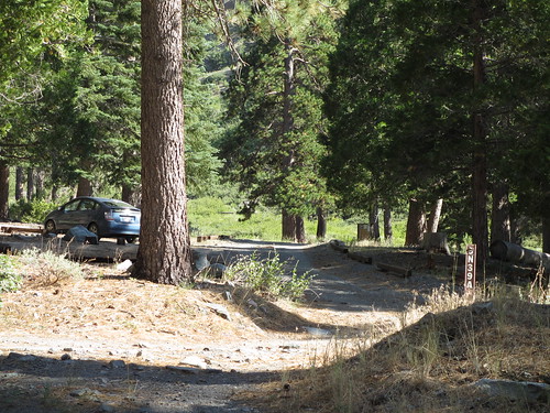
Prius at Lupine CG by moore91024, on Flickr
Not for the faint of heart, but it can be done by an experienced off-pavement driver. Go slow and expect to get out and throw rocks to the side. Slowest_Hiker cannot be held responsible for your Blue Ridge Rd. driving outcome.
Prius at Lupine CG by moore91024, on Flickr
Not for the faint of heart, but it can be done by an experienced off-pavement driver. Go slow and expect to get out and throw rocks to the side. Slowest_Hiker cannot be held responsible for your Blue Ridge Rd. driving outcome.
-
BrownMtnBob

- Posts: 96
- Joined: Mon Oct 15, 2012 1:55 pm
I want to get in one of my cold weather campings up at Guffy (maybe Blue Ridge....depending). Being Halloween....anyone have some insight as to how much longer I have to drive down that road to either spot?
There are other options, such as Crystal Lake and others.....but I do like the solitude of Guffy. I get out my laptop and do work in the afternoon, by the fire....it's awesome.
There are other options, such as Crystal Lake and others.....but I do like the solitude of Guffy. I get out my laptop and do work in the afternoon, by the fire....it's awesome.