

I very much doubt it. The West Fork Road is open on weekends. He could have started from there to do Triplets via a known route, which is hard enough. Starting from Monrovia would almost certainly be beyond Colin's ability, unless he planned a multi-day trek alone, which is also unlikely.AndrewBlackwood wrote: ↑As a periodic quest of his, is there a chance he did it again?
Missing forum member (Colin Walker)
LA Times article.
After a week of searching the steep slopes of the San Gabriel Mountains, rescue teams have found no sign of a 53-year-old hiker who was last seen walking toward a trailhead near Monrovia Canyon, police say.
Colin Walker of South Pasadena parked his car and headed into the wilderness shortly after dawn July 15 on Ridgeside Drive in Monrovia, police said. A Ring home security camera taped him setting off in dark shorts and a gray T-shirt with a large green backpack and walking sticks.
An avid hiker, Walker has been researching lost trails and lost water features, said Domenica Megerdichian, deputy city manager of South Pasadena.
Walker’s wife and 12-year-old son were out of town on the Friday he vanished, Megerdichian said. Search and rescue teams were dispatched to the area two days later after he failed to check in with his family or co-workers. His vehicle was found parked near Monrovia Canyon trailheads, she said.
Search teams from all across Southern California have been using dogs, horses, helicopters, drones and thermal-seeking technology, police said, but the steep terrain, thick vegetation and extreme heat have hampered progress. The trailheads near the spot where Walker disappeared are on the edge of the suburbs just below Mt. Wilson.
Authorities would like anyone with information on Walker’s whereabouts to call the South Pasadena police watch commander at (626) 403-7270.

I gave them the old maps with the connector and the switchback routes. I've been told these have been checked. The problem is that these trails are either gone or hard to locate, thus difficult to impossible to follow without GPS help. And I don't think Colin carries a GPS device.
Has it been determined whether he was carrying trail work tools or something else in that pack? Though if he were trying to work on an overgrown trail, one would think that that might've been clear to the search crews...
The LA Times article quoted someone saying that Colin "has been researching lost trails and lost water features." What might that include in that area -- waterfalls that have gone dormant with the drought? Old water tanks? Whatever it is, I'm sure SAR has been looking into it. I hope he is found soon.
Everything points to that conclusion. It's a near certainty that he was packing the regular tools.
He was researching the lost trail in the east fork of Santa Anita Canyon. I'm not sure what is meant by "lost water features."The LA Times article quoted someone saying that Colin "has been researching lost trails and lost water features." What might that include in that area...
-
tonesfrommars

- Posts: 17
- Joined: Thu Apr 26, 2018 10:15 pm
The search teams did not find Colin yesterday, nor any sign or clue that could not be accounted for. Today the operation will transition to „limited continuous“ status, which means that they will no longer be pulling resources or man power from outside the area. The local SAR team will be reviewing all of the efforts to date with a fine-toothed comb to see if they can identify any routes, sites, or scenarios that they might not have exhausted to their satisfaction, and will pursue those as they are identified. We are told that the Sierra Madre search and rescue team will post to their social media accounts today with more information on the scope of this initial phase.
https://www.instagram.com/sierramadresearchandrescue
https://www.facebook.com/SierraMadreSearchandRescue
As many of us are feeling the urge to go out on the trails to see for ourselves and help look for him, I’d like to offer a few very important reminders:
There is a closure in the Angeles National Forest pursuant to the Bobcat fire in 2020 which encompasses a significant portion of the search area. Please abide by the closure and review the closure order and map so you are aware of the dangers and also any fines which may result from violating it.
https://www.fs.usda.gov/alerts/angeles/ ... ?aid=80638
https://www.fs.usda.gov/Internet/FSE_DO ... 111500.pdf
Please be safe and responsible if you go into the mountains. Do not travel alone, carry a satellite beacon or communication device, let someone know where you are going. Check the weather forecast and be prepared for conditions.
I want to assure everyone that every one of the suggestions, ideas, thoughts, and speculations shared here and elsewhere were immediately brought to the SAR team and they frequently factored significantly into the planning and execution of the search. It goes without saying that if anyone has new information, thoughts, or ideas at any time, the SAR team and Sheriff’s department is open to hearing them, and they can best determine if further action is warranted.
All of the SAR personnel are volunteers. They are not out in the field because it’s their job. We have come to understand that it does not sit well with them that they have not yet managed to locate Colin and bring him back to us.
Here is just some thoughts for what it is worth. I think it is important to start off with what we know for certain otherwise you end up in conjecture and it gets further and further from the truth as people make more and more fanciful ideas, when probabilities are always the simplest.
What we know are:
1. Walker is an experienced hiker
2. It was going to be an extremely hot day and all routes were going to be exposed.
3. He started from Ridgeside Drive onto Lower Clamshell.
4. He started hiking at ~6:30 AM on Saturday morning
5. He brought a larger pack then would normally be taken on a regular day hike.
6. He loved finding old trails that were no longer in use.
We can assume that the large backpack was there to carry tools as he was planning to go off-route. It seems doubtful that he would be able to to get much further then Clamshell Peak and that ridge without having to descend in the heat of the day which as an experienced hiker he would avoid. This is why the East Fork of Santa Anita seems doubtful to me.
This leaves us with closer locations as probable spots. The most obvious are the trails in lower Monrovia Canyon. I know that the old trail coming out of Monrovia canyon that connects with the Clamshell firebreak is in terrible shape and unsure if it is even passable now but that would be one of the directions to go to try and connect with those old trails in that area or from a little bit up the firebreak. Ayers commented on these trails and that makes a lot of sense as far as where he would go with the time available. The area is covered with brush and you could probably pass within yards of a person and miss them so extensive search of that area doesn't preclude his location in that area.
I can't really see any other spots further on the Lower Clamshell that would make sense to visit. It could be possible to try and cut up the ridge from a spot near Big Santa Anita to Upper Clamshell but what would be the point of that so the search area should probably be closer to the TH.
As SAR is scaling back operations, and nothing has been found, I'm compelled to share an important fact, of which SAR was made aware early on in this search effort. Colin had drafted an email to me but did not send it. His brother found it and sent it to me later. In the email titled "East Fork Trail recon," Colin indicated that he was planning to "risk a venture in the heat" and "attempt to find signs of the trail at the upper end where it joins Clamshell Road west of Monrovia Peak." If Colin made it to the upper road, he might be anywhere in the vicinity of that old trail. If he did not make it to the road, he might be anywhere below it. Of course he could have also changed his mind last minute and went in some other direction off the Lower Clamshell Motorway. I'm currently trying to get a permit to enter the closure area. I want to walk the Upper Clamshell looking for signs of cuttings. I know that SAR was looking for cuttings, and most likely they didn't find any because there aren't any. But I'm old school and need to know for myself. Maybe something was missed.
I would love to come with! How can I apply for a permit to enter?Sean wrote:As SAR is scaling back operations, and nothing has been found, I'm compelled to share an important fact, of which SAR was made aware early on in this search effort. Colin had drafted an email to me but did not send it. His brother found it and sent it to me later. In the email titled "East Fork Trail recon," Colin indicated that he was planning to "risk a venture in the heat" and "attempt to find signs of the trail at the upper end where it joins Clamshell Road west of Monrovia Peak." If Colin made it to the upper road, he might be anywhere in the vicinity of that old trail. If he did not make it to the road, he might be anywhere below it. Of course he could have also changed his mind last minute and went in some other direction off the Lower Clamshell Motorway. I'm currently trying to get a permit to enter the closure area. I want to walk the Upper Clamshell looking for signs of cuttings. I know that SAR was looking for cuttings, and most likely they didn't find any because there aren't any. But I'm old school and need to know for myself. Maybe something was missed.
-
AngelMount
- Posts: 3
- Joined: Sat Jul 22, 2023 12:26 am
?Sean wrote:As SAR is scaling back operations, and nothing has been found, I'm compelled to share an important fact, of which SAR was made aware early on in this search effort. Colin had drafted an email to me but did not send it. His brother found it and sent it to me later. In the email titled "East Fork Trail recon," Colin indicated that he was planning to "risk a venture in the heat" and "attempt to find signs of the trail at the upper end where it joins Clamshell Road west of Monrovia Peak." If Colin made it to the upper road, he might be anywhere in the vicinity of that old trail. If he did not make it to the road, he might be anywhere below it. Of course he could have also changed his mind last minute and went in some other direction off the Lower Clamshell Motorway. I'm currently trying to get a permit to enter the closure area. I want to walk the Upper Clamshell looking for signs of cuttings. I know that SAR was looking for cuttings, and most likely they didn't find any because there aren't any. But I'm old school and need to know for myself. Maybe something was missed.
You are right then he almost certainly made it to the ridge. Was the Clamshell Peak register checked for a signature? The other issue is that the north side doesn't have the brush of the south side, so you may not see clippings as far as access point to start descent or even any evidence of passage. You do have a good place to start off based on where the trail supposedly met up with the fireroad. It would be great to get a map of what areas have been searched in that area because that becomes a much larger area to canvass. Also based on his East Fork post here, he had mentioned that a section of the trail had been blasted through in rock and was sketchy to try now, so could be a dangerous endeavor in and of itself, if that is where he got up to.Sean wrote: ↑As SAR is scaling back operations, and nothing has been found, I'm compelled to share an important fact, of which SAR was made aware early on in this search effort. Colin had drafted an email to me but did not send it. His brother found it and sent it to me later. In the email titled "East Fork Trail recon," Colin indicated that he was planning to "risk a venture in the heat" and "attempt to find signs of the trail at the upper end where it joins Clamshell Road west of Monrovia Peak." If Colin made it to the upper road, he might be anywhere in the vicinity of that old trail. If he did not make it to the road, he might be anywhere below it. Of course he could have also changed his mind last minute and went in some other direction off the Lower Clamshell Motorway. I'm currently trying to get a permit to enter the closure area. I want to walk the Upper Clamshell looking for signs of cuttings. I know that SAR was looking for cuttings, and most likely they didn't find any because there aren't any. But I'm old school and need to know for myself. Maybe something was missed.
I would also go and search but not in this heat unless we could get permission to drive up there.
-
Uncle Rico

- Posts: 1386
- Joined: Thu Mar 20, 2008 7:48 pm
Assuming he did this, what do you suppose is the entry point into BSA he was searching for? Where the East Fork hits Spring Camp (which would be west of Monrovia Peak) or where that subsidiary drainage comes in further south and immediately west of Rankin?
Also, I presume that if Colin was going to make this attempt, he went up the ridge to Clamshell and did not go up Monrovia Canyon. That would have made it an awfully long day in the heat and require that he ignore the closure.
Also, I presume that if Colin was going to make this attempt, he went up the ridge to Clamshell and did not go up Monrovia Canyon. That would have made it an awfully long day in the heat and require that he ignore the closure.
The e-mail written but not sent is as close to a guarantee that he went to the East Fork regardless of heat or closure. The more recent maps show the connector to be just west of Clamshell and the older map is just west of Rankin. The Clamshell route would be shorter but not as accurate to the old trail. Going from Rankin would be a long endeavor with a lot more off-trail to deal with, both possibilities would have to be investigated.Uncle Rico wrote: ↑Assuming he did this, what do you suppose is the entry point into BSA he was searching for? Where the East Fork hits Spring Camp (which would be west of Monrovia Peak) or where that subsidiary drainage comes in further south and immediately west of Rankin?
Also, I presume that if Colin was going to make this attempt, he went up the ridge to Clamshell and did not go up Monrovia Canyon. That would have made it an awfully long day in the heat and require that he ignore the closure.
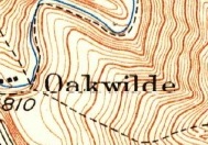
This map shows where the lost switchbacks hit the Clamshell Road. He was probably aiming for this area.Uncle Rico wrote: ↑Assuming he did this, what do you suppose is the entry point into BSA he was searching for?
I don't know. According to a 2016 Lower Peaks Guide, the register on Clamshell is located in "a concrete hole with an iron lid next to a bush."
Yes, he may have tried an alternate access point. Apparently there are some decent drop-in points at the gullies. I've never tried it myself.The other issue is that the north side doesn't have the brush of the south side, so you may not see clippings as far as access point to start descent or even any evidence of passage.
The first time I hiked Clamshell Peak, on return I was too busy chatting and mistakingly took us down the wrong ridge (ended up to the ridge just west of route). This route ended abruptly at ~2800' where there was thick brush, but oddly a chainsawed section heading southeast into Clamshell Canyon. We went off route into the canyon, I vaguely remember some scrambling to get around some water features at the time (circa 2008), probably more rain now.
Just noting in case he accidentally or intentionally could have explored this way.
Just noting in case he accidentally or intentionally could have explored this way.
I'm new here but a couple of points for people looking to go up there:
SAR teams were often inserted and extracted via helicopter, and had ropes and descending gear with them. Lots of cliffs in the canyons. Many times the hoist was the only way out. Don't follow human tracks unless your absolutely sure you can get back.
Thick and impassable brush was common.
Bring lots of water, and be done by noon. It's hot.
SAR volunteers in that area have been very busy. Please use caution.
I think these are good cautions. In terms of searching, it's especially unfortunate that much of the search area is in officially closed area, and also that it continues to be so hot.Aaron134 wrote: ↑I'm new here but a couple of points for people looking to go up there:
SAR teams were often inserted and extracted via helicopter, and had ropes and descending gear with them. Lots of cliffs in the canyons. Many times the hoist was the only way out. Don't follow human tracks unless your absolutely sure you can get back.
Thick and impassable brush was common.
Bring lots of water, and be done by noon. It's hot.
SAR volunteers in that area have been very busy. Please use caution.
Am I correct in understanding that the Monrovia Hillside Wilderness Preserve is open but that the Clamshell Truck Trail is closed beyond there? Is there a good map showing the boundaries of the Wilderness Preserve? From Alltrails, one can see that despite its closed status, some people have been going up the Clamshell Truck Trail.
Depending on when he drafted that email to Sean, a lost trail to the eastern fork of BSA does seem a likely goal for Colin, though of course he could've changed his mind and gone somewhere else.
Sean, would Colin have had the old map you posted, or other old maps? Was he likely to have looked at historical satellite photos? (Sometimes those can be helpful when finding old trails, though satellite photos can be misleading.)
If SAR was given that info, they almost certainly searched that area. But I can understand wanting to see for oneself. In addition to possible cuttings, and making the sad assumption that Colin is deceased, there may be two more indicators of his location: odors and bird activity.
It's frustrating that we can't at least go up the Clamshell Truck Trail and use our eyes and noses. (In terms of looking for bird activity, I don't think any officially-open areas overlook that area. I guess a drone could look for birds but it might just scare them off.)
He probably had them committed to memory. Studying old topos and aerials is standard practice for trail hunters.
-
Paul Ayers
- Posts: 42
- Joined: Fri Sep 14, 2012 5:21 pm
Here is a 1938 aerial showing the switchback trail Sean is referring to. It is not visible on a 1928 nor a 1944 of the same area. Does the trail have a name?

East Fork via santaanitacanyon?Paul Ayers wrote: ↑Here is a 1938 aerial showing the switchback trail Sean is referring to. It is not visible on a 1928 nor a 1944 of the same area. Does the trail have a name?
-
Paul Ayers
- Posts: 42
- Joined: Fri Sep 14, 2012 5:21 pm
Here is a 1941 description of the East Fork Trail from Will Thrall; Thrall used the trail for his "You Hike Today" a number of times in the 1930s.
Oh wow! Where did you get that aerial?Paul Ayers wrote:Here is a 1938 aerial showing the switchback trail Sean is referring to. It is not visible on a 1928 nor a 1944 of the same area. Does the trail have a name?
-
Paul Ayers
- Posts: 42
- Joined: Fri Sep 14, 2012 5:21 pm
FrameFinder, here is the link: https://mil.library.ucsb.edu/ap_indexes/FrameFinder/
-
tonesfrommars
- Posts: 17
- Joined: Thu Apr 26, 2018 10:15 pm
@Paul Ayers Colin had the 1938 aerial in his “east fork Santa Anita” trail project folder on his PC, and that image was open on his desktop. He was definitely intending to go find those switchbacks the evening before he went out, but of course we don’t know where he actually went in the morning.
Gesendet von iPhone mit Tapatalk
Gesendet von iPhone mit Tapatalk
-
Paul Ayers
- Posts: 42
- Joined: Fri Sep 14, 2012 5:21 pm
If Colin went up the trail towards Clamshell Peak, it appears it was his first ascent. For those not familiar with the ascent to Clamshell Peak from the trailhead where Colin left his car, Iron Hiker has a good report dating from 2014 with followups to 2019. A consistent theme is steepness, and the tendency to lose the trail towards the top. The hike has a 3545' gain which I know Colin can do from his work around Switzer's but conditions on the day he went in were certainly challenging. https://ironhiker.blogspot.com/2014/06/ ... -peak.html