
Missing forum member (Colin Walker)
I have done this hike five times and it is steep especially at the beginning but a pretty clear route. I would expect based on the search done last week that he made it to the ridge, there really isn't many places to get lost on the way up and there are no drop offs. He must be in the East Fork.
Hey folks, I'm not a friend of Colin's, but took interest in his MP report as a fellow hiker. I've been following along with the thread and have a possible route theory.
As Colin stated, he was going to "attempt to find signs of the trail at the upper end where it joins Clamshell Road west of Monrovia Peak."
There appears to be an old unmarked trailhead to the west of Monrovia Peak. It also appears to go somewhat SE down the mountain, running parallel and eventually connecting to Upper Clamshell Truck Road at the White Saddle Junction.
Has there been extensive searching around this area to the west of Monrovia Peak on the descent to White Saddle?
Google Maps: Unknown Trailhead
Google Earth Project: Possible route
The coordinates of the trailhead: 34°12'39.3"N 117°58'12.9"W
Might it be possible that he hiked up Clamshell Peak to Monrovia Peak? If so, may he have tried this unknown trail back down? This is especially considering it would connect with the fire road near White Saddle and it would be a smooth descent and a loop-type hike back to Monrovia Canyon?
Thanks for considering my theory on this. I'm interested to hear your feedback.
-Lau

Hmmmm, food for thought indeed!lauhikes wrote: ↑ As Colin stated, he was going to "attempt to find signs of the trail at the upper end where it joins Clamshell Road west of Monrovia Peak."
There appears to be an old unmarked trailhead to the west of Monrovia Peak. It also appears to go somewhat SE down the mountain, running parallel and eventually connecting to Upper Clamshell Truck Road at the White Saddle Junction.
Might it be possible that he hiked up Clamshell Peak to Monrovia Peak? If so, may he have tried this unknown trail back down? This is especially considering it would connect with the fire road near White Saddle and it would be a smooth descent and a loop-type hike back to Monrovia Canyon?
Pros:
• Colins says "west of Monrovia Peak" and not west of Rankin Peak, which is where the old switchback trail into Santa Anita East Fork is located. Granted the historic Santa Anita East Fork switchback trail IS still west of Monrovia peak as well, but there is Rankin in between.
• Your proposed route is a reasonable loop to make on a hot day when you safely only have the morning hours to work with.
Cons:
• Your "White Saddle Junction Trail" route down (which appears on satellite imagery to be a fire break) Doesn't actually join Upper Clamshell Road at it's "upper end" because Upper Clamshell Road swings north to Spring Camp before joining your trail. It appears to be another fire break which joins your trail along the ridge from Rankin to Monrovia Peaks.
• according to Sean, Colin's unsent email was titled "East Fork Trail recon" which suggests Colin was looking for trails into the East Fork of Santa Anita and not on the south face of Clamshell/Rankin/Monrovia.
Thanks for the feedback, Nate and the info that Colin was only planning to hike in the morning hours.
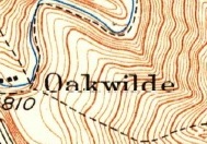
The Google Maps or Google Earth links above show the marker of the unknown trail and its faint southerly route which connects to what they're calling Upper Clamshell Truck Trail at White Saddle. Older maps called this trail Sawpit. At that fork, it splits into Monrovia Canyon Truck Trail & Silver Fish Truck Trail.
I've attached some screenshots & drawn a green line on the unknown trail located to west of Monrovia Peak.

-
Uncle Rico

- Posts: 1386
- Joined: Thu Mar 20, 2008 7:48 pm
What if Colin made the same mistake that teke made on the descent and got off on that lateral ridge to the southwest of the main ridge route? Ultimately I think he would have hit the lower stretch of Clamshell Truck Trail and realized his error. But instead of backtracking like teke did, what if he tried to cut diagnally across the upper portions of intervening canyon? Or maybe just continue down the steep ridge past the water tank? I know the copters spend a lot of time hovering over that canyon so maybe that thread has played out.
https://caltopo.com/map.html#ll=34.1842 ... z=15&b=mbh
https://caltopo.com/map.html#ll=34.1842 ... z=15&b=mbh
-
Uncle Rico
- Posts: 1386
- Joined: Thu Mar 20, 2008 7:48 pm
See Ze's comment above. I guess that was what I was thinking.
-
Uncle Rico
- Posts: 1386
- Joined: Thu Mar 20, 2008 7:48 pm
Nevermind my comments above. Colin's body was apparently found by SAR yesterday afternoon. That's all I know.
-
tonesfrommars

- Posts: 17
- Joined: Thu Apr 26, 2018 10:15 pm
I was just writing a note here for anyone not in our WhatsApp group. Colin was found yesterday and his remains are being recovered this morning. We will know more soon, and I will share here as we learn more. Thanks to you all for your kind thoughts and rememberences and also for helping to brainstorm in the effort to find him. I am heartbroken. I know that Colin really enjoyed this forum and community, and shared his love for these amazing mountains with you all.
Gesendet von iPhone mit Tapatalk
Gesendet von iPhone mit Tapatalk
-
Paul Ayers
- Posts: 42
- Joined: Fri Sep 14, 2012 5:21 pm
Colin working the Station Ridge Trail, 3/23/2018.


-
- Looking up the ridge on Rose Peak. July 2023.
-
- At Supercloud Hollow with friends. July 2023.
-
- Summiting historic Panorama Peak. May 2023.
-
- Enjoying a great view on West ridge of Panorama Peak. May 2023.
-
- Clearing the Switzer's High Trail. Arroyo Seco. August 2018.
-
- Restoring the Station Ridge Trailhead. Arroyo Seco. March 2018.
-
AngelMount
- Posts: 3
- Joined: Sat Jul 22, 2023 12:26 am
Very sad outcome; ? I really hoped there was a chance he'd be found alive. Rest in Peace Colin Walker as you walk and immerse yourself in the celestial mountains, replicas of the San Gabriels which you loved so much, and where you spent so much time communing with nature and clearing the paths for others to enjoy. May your love for your family and friends be felt in a special way by them as the rush of memories abound. My deepest condolences to them.

If the helicopter activity this morning is any indication, it appears he wasn't very far up the ridge from where he had started when something happened.
I know people complain about InReach, but I use mine in really narrow canyons and it still does a pretty good job. I hope everyone uses something that can be tracked in an emergency.
I know people complain about InReach, but I use mine in really narrow canyons and it still does a pretty good job. I hope everyone uses something that can be tracked in an emergency.


Here's the recovery flight: https://flightaware.com/live/flight/N14 ... /KPAI/KPAI
And the map: https://caltopo.com/m/3KN56
Looks like Colin got into trouble very early in the hike. Be safe, everyone.
And the map: https://caltopo.com/m/3KN56
Looks like Colin got into trouble very early in the hike. Be safe, everyone.

Appears he was near the start or on the steepest part of the ridge. It is also at a junction of a trail I didn't know was there. Maybe he was trying to find or use that trail that headed down to North Canyon. That would have made a loop and gotten him back before the afternoon.dima wrote: ↑Here's the recovery flight: https://flightaware.com/live/flight/N14 ... /KPAI/KPAI
And the map: https://caltopo.com/m/3KN56
Looks like Colin got into trouble very early in the hike. Be safe, everyone.
Super surprised they didn't find him until now that is right at the beginning of the climb up. I would assume a medical situation separate from the hike or heat exhaustion on the way down. It is the steepest section but can't see you dying on that section unless a fluke fall and hit your head on a rock but you should be found right away in that case.
Could have been looking for the Bill Cull trail.
clamshell-rankin-monrovia-peaks-1-17-09-t1144.html
viewtopic.php?p=1526#p1526
clamshell-rankin-monrovia-peaks-1-17-09-t1144.html
viewtopic.php?p=1526#p1526
When I hiked Clamshell and Monrovia in 2011, I must have done the top piece of this trail, because it was super sketchy and led over to the palm trees. They call it Four Palms now. I thought it was an animal track at the time, and was confused for a few minutes until I realized I was off route.
Ze quotes Robinson on the linked thread:
I wonder if Colin read that, because he didn't refer to it as the "Monrovia Peak Trail." In the '34 USGS, the trail hits the ridge, then forks. One branch contours around the head of the canyon to Spring Camp, the other continues straight up the ridge, along a firebreak, to Monrovia Peak.Then I read this again about 'trails that once were'
"Monrovia Peak Trail: This was once a favorite of Big Santa Anita Canyon hikers, going from Fern Lodge up the East Fork to Clamshell Ridge and on to the summit. Today, the middle stretch from the East Fork up to the Clamshell fire road is completely overgrown and impassable."
"Deer Park-Monrovia Trail: Ben Overturff built this trail from Deer Park Lodge up the long southeast ridge of Monrovia Peak to the summit in 1914-1915. It fell into disrepair when Deer Park was abandoned after the 1938 flood."
That's interesting about the trail out of Deer Park. Kevin Singleton emailed me a map of it during the search. It has been abandoned longer than the East Fork Trail. Anyone seen signs of it?