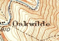
As some of you know, I am trying to come up with a plan of the Oakwilde Resort, ca. 1930s, perhaps leading to a ruins restoration project. I have made an appeal for photos, etc. and received some material that was helpful. One is a postcard of what I believe to be the east end of the resort [attached]. In it, at upper right, you can see the end of CCC Ridge diving towards the Arroyo Seco, while at left is a lodge-looking structure. Looking at a Google Earth image dated 11/14/2009, i.e., just after the Station Fire of 9/2009, a foundation is seen which matches the location of the structure seen in the postcard. Little steps like this will hopefully lead me to my goal.
If you have any thoughts, photos, etc. that you think might help, I would love to hear/look at them. One thing people may have readily is photos of the resort 1990-8/2008.
Thanks
Paul
Oakwilde mapping project

-
Paul Ayers
- Posts: 42
- Joined: Fri Sep 14, 2012 5:21 pm
I'm thinking we could use the aerials to find coordinates for each building, then use the coordinates on the ground to flag probable locations and boundaries. It would help to know where we should clear brush and start poking around.

-
Paul Ayers
- Posts: 42
- Joined: Fri Sep 14, 2012 5:21 pm
I'll work on finding software to overlay old aerials on Google Earth. In the meantime, here are a couple of additional photo clues. First from the Cates trip of 4/9/2008, a photo showing the artifacts seen in the 11/2009 Google Earth image, with the foundation wall at left and two trough or stove appearing objects also seen in the 11/2009 aerial. Second, a 12/2003 Google aerial showing the foundation wall at coordinates from 11/2009 aerial.