"Ridge to River" - A San Gabriel Mountain Death March

TRs for the San Gabriel Mountains.
Post Reply
User avatar
Blaise
Posts: 24
Joined: Sat Nov 17, 2018 5:46 pm

Post by Blaise »

34 Miles. 11,500' Elevation Gain. 27.5 hours of hiking without stopping to sleep.

The most physically challenging adventure I've ever done, and possibly will ever do.

The route: East Fork Trailhead - Iron Mountain - Mt. Baldy - Dawson Peak - Pine Mountain - Down Pine Mountain Ridge to Lupine Campground - Cabin Flats - East Fork River all the way down past Bridge to Nowhere - Back to the East Fork Trailhead. We did this from Tuesday August 8 to Wednesday August 9.

Has anyone ever been crazy enough to try to do this whole route in one go? I can't find any record of it happening before. But now it has been done.

My dad and I started thinking of this route back in late 2020 when we didn't have anything better to do. We had been eying the Iron to Baldy route for a while, but didn't like the idea of a shuttle back to the start point. We like to start and end our hikes in the same place. Looking at possible options, going down Bear Flats and heading back through Cow/Cattle canyon looked a bit boring, not to mention the question of what the Thompson Ranch folks would think about us traipsing through their property. A loop to the north of Baldy would have to be longer, but also much more exciting and remote. The real question was whether we would have the strength to do it.

In 2021 we made our first attempt, which ended up just being the classic Iron to Baldy route. By the time we got to the summit of Baldy, we knew we didn't have the strength to continue on the next 18 miles of the route. For a while, I questioned the feasibility of doing such a route in one go. But as the memories of the pains of that hike faded, we decided that the human body was capable of much more than we had expected from it the previous attempt. We would just tell ourselves to keep moving and ignore the pain.

After a few attempts to set down a date, we nailed down August 8th of this year. I made this video to document this trip:

My video explains most of the hike and how it went. I'll mention a few details here as well:


East Fork Trailhead to Iron - went well, made good time. The rains have definitely fueled the growth of the brush. The plants are growing into the path much more than on any of my previous 3 times summiting Iron (in 2018, 2020, and 2021). Though it didn't slow our progress much at all, the difference was clear.

Screen Shot 2023-08-19 at 10.55.33 PM.png
Screen Shot 2023-08-19 at 10.57.34 PM.png
San Antonio Ridge - Sticking to the top of the ridge and tending to the north side paid off. We made much better time than the previous two times on the ridge (2018 and 2021). The north side is more exposed manageable. The ascent from the ridge up to West Baldy was brutal as expected, but someone put orange ribbons on the trees, which kept us on a manageable trail and saved us some of the time and effort we spent in 2021 looking for the best way up.
Screen Shot 2023-08-19 at 10.57.56 PM.png
Baldy to Pine Mountain - We quickly stopped at the summit for a break, and then committed to the rest of the hike by going down Baldy's north backbone. We considered this our "point of no return", as it would be much more difficult to bail after leaving Baldy's summit. Close to the summit of Dawson, I couldn't get enough air into my lungs and had to sit down for a while to catch my breath and get some food in my stomach. We didn't go to the proper summits of Dawson or Pine, but stuck to the main trail.
Screen Shot 2023-08-19 at 10.58.36 PM.png
Pine Mountain to Lupine - After Pine Mountain, we descended down its long ridge. The brush was thick and thorny at times, but progress was not terribly so. It was about 7pm in the evening by the time we got to Columbine Spring. We had almost completely ran out of water at this point. We each packed about 5 liters of water at the start of the hike. All I had left when we got to the spring was about half a liter of thick soupy lemonade (I filled the bottle about half full with powder before the hike). We drank the water from Columbine unfiltered and it lasted us the rest of the way home. No sickness to report!
Screen Shot 2023-08-19 at 10.58.52 PM.png
Lupine to Cabin Flat - A nice gentle descent on the old dirt road.

Cabin Flat to Mine Gulch - The worst. The absolute worst. The sun set and it was completely dark by the time we started this portion of the route. We started by plowing through 7' tall nettles and then proceeded down the river. Though we exited the river several times in search of any trails or passable dry land, we kept ending up stuck at a dead end in the brush. Even with a good flashlight, looking ahead to see if the trail goes anywhere useful is nearly impossible. Each time we had to cut our way back towards the sound of the river and plunge in again. The water here was much deeper than when I had seen it in August of last year, which was unsettling. Finally as we neared the junction with Vincent Gulch and Mine Gulch, we found some sections of passable dry land. All in all, it took us over three hours to go the 2 miles from Cabin Flat to Mine Gulch. The mental toll such slow progress took on us was serious.
Screen Shot 2023-08-19 at 10.59.06 PM.png
We did find this cool spider:
Screen Shot 2023-08-19 at 11.00.01 PM.png
Mine Gulch to Bridge to Nowhere - It seemed interminable in the darkness. It felt like we were moving, but the landmarks (Fish Fork, Iron Fork) came so slow. After so much fatigue and effort, focusing the mind becomes all the more important. Things in the distance started to look like the things I wanted to see - buildings, cabins, man-made objects, trails, campsites. I had to ignore it and keep moving. The trees, rocks, and water also started to take on personalities of their own. In my mind, they were trying to slap me in the face, grab my hat, and knock me over. I would to get angry at them, and that sometimes that helped me keep moving. We passed the Fish Fork campsite at around 2 or 3 am and there were two tents there. (Anyone?) It was tempting to stop there.

We found a big horn skull, but were too tired to think of hanging on to it.
Screen Shot 2023-08-19 at 11.00.21 PM.png
Since before Mine Gulch, I had been worried about the height of the river, especially the crossing at the north end of the Narrows, which I remembered as fast and waist-deep the last time we were there. I was worried it would be worse. Thankfully, when we reached that spot, we found the whole riverbed seems to have changed at that spot (probably due to the winter floods), and the crossing was no problem at all. After that, it was very familiar territory and the way got easier.

Bridge to Nowhere to End - The sky brightened as we got to the Bridge to Nowhere, and though our legs were feeling worse and worse, our closeness to the end kept us moving. Towards the end of our hike, we met the first hikers of the day making their way to the bridge to nowhere. Little did they know we had been hiking since before they woke up the day before. Finally, we reached the parking lot, fist-bumped, and our hike was over. We went home to get our well-deserved rest.

Shout-out to my dad, who is always an absolute beast when it comes to these hikes. He never trains except to play sports sometimes and ride his bike on occasion, but at 49 he still has amazing endurance and can still outlast me despite the fact that I train much more than he ever does.

Here's the Stats:

Location Time Mileage
East Fork Parking Lot 0:00 0.00
Coldwater Saddle 2:00 5.00
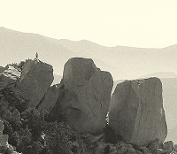
Iron Mountain 4:26 7.00
Mount Baldy 9:26 12.20
Dawson Peak 10:51 13.70
Pine Mountain 12:01 14.80
Lupine Campground 14:41 18.70
Cabin Flat Camp 16:03 21.20
Mine Fork 19:11 23.75
Bridge to Nowhere 25:08 29.50
East Fork Parking Lot 27:29 34.00
User avatar
David R
Posts: 522
Joined: Sun Jun 12, 2011 10:28 pm

Post by David R »

Rick Kent did it the opposite way and enjoyed himself as much as you did. Now you need to finish the full death march.

30-miles-to-nowhere-t1599.html
User avatar
Sean
Posts: 3712
Joined: Wed Jul 27, 2011 12:32 pm

Post by Sean »

Thanks for the report, and congratulations on completing such a tough hike. What sort of hikes did you do to train for this?
User avatar
Gene
Posts: 196
Joined: Mon Dec 26, 2011 7:54 pm

Post by Gene »

Excellent, I'm watching the video as I type this.
User avatar
Uncle Rico
Posts: 1386
Joined: Thu Mar 20, 2008 7:48 pm

Post by Uncle Rico »

Big
User avatar
Slowest_Hiker
Posts: 245
Joined: Sun Jul 31, 2011 12:31 pm

Post by Slowest_Hiker »

Awesome. Ty for sharing
User avatar
Girl Hiker
Posts: 1297
Joined: Fri Apr 04, 2014 7:46 am

Post by Girl Hiker »

Congratulations to you and your dad!
User avatar
Girl Hiker
Posts: 1297
Joined: Fri Apr 04, 2014 7:46 am

Post by Girl Hiker »

Wow! I just watched your video. Excellent documentary! I've never hiked on the San Antonio ridge and the notches look a bit intimidating but very doable.
By the way big props to your dad, he's a beast!
User avatar
Blaise
Posts: 24
Joined: Sat Nov 17, 2018 5:46 pm

Post by Blaise »

Sean wrote: Thanks for the report, and congratulations on completing such a tough hike. What sort of hikes did you do to train for this?
I mostly run to train for the hikes I do. It's often hard set aside enough time to train by hiking, so I try to run every day if possible. Earlier this summer, I got to go to Switzerland, so I did a few cool hikes there too.
User avatar
Blaise
Posts: 24
Joined: Sat Nov 17, 2018 5:46 pm

Post by Blaise »

David R wrote: Rick Kent did it the opposite way and enjoyed himself as much as you did. Now you need to finish the full death march.

30-miles-to-nowhere-t1599.html
Yikes
User avatar
Nate U
Posts: 215
Joined: Wed Apr 05, 2023 7:38 pm

Post by Nate U »

Hardcore walk. Much respect. Trudging down the east fork in the dark with that many miles/elevation gain/time behind you already is the real deal.
User avatar
AW~
Posts: 2035
Joined: Mon Oct 01, 2007 12:00 pm

Post by AW~ »

Yeah, big effort...kind of spiritual quest big.
So cool...... Spooky trees and rocks...halloween :)
User avatar
Taco
Posts: 5991
Joined: Thu Sep 27, 2007 4:35 pm

Post by Taco »

That's pretty dope. Nice job. Feels good to stop. I know that feeling... friggin Prairie Fork is a true pain in the ass, and then you pop out near Mine Gulch and gotta walk south. At least the sun wasn't out for that first part on the way to Fish Fork.

I am planning on something roughly similar, though easier and with a bike. You've given me a lil more inspiration.
User avatar
Ze Hiker
Posts: 1430
Joined: Mon Jul 28, 2008 7:14 pm

Post by Ze Hiker »

Excellent!

Next, how about Baldy - Iron - Baden Powell? I think about 13,000' of elevation gain.
Post Reply