

Trailhead from the parking lot
Devils Chair
Since I have never visited this place it was about time to go, especially with warmer weather approaching. A relatively late-morning drive got me to one of the last two parking spots and I wandered around the facilities for a while looking at various plaques and diagrams before heading out on the trail. Not much to talk about here, although two stream crossings had ample water flowing. The first one I splashed through while other folks were trying to rock-hop across, the second one even had some nice-looking pools just below the trail but I wasn't up to getting that wet on my way back. I don't know where all the people were, as I hardly saw anyone on this section of the Pacific Crest Trail. I had the Chair to myself for about 15 minutes so I did a lot of contemplating the state of our world these days. I also ate some almonds and mango for a breakfast snack. The return trip was also uneventful, I refilled one of my water bottles at the stream. There were plenty of small flowers along the way and some pretty nice stands of poodle dog bush near the trail.
Trailhead from the parking lot This place is definitely a geological oddity PCT across the canyon, plenty of burnt trees still standing Stream with clear and cool water Larger view of this Los Angeles County Park Balancing act - this rock is about twice my height Devils Chair at the end of that walkway Colorful landscape Somewhere around here I thought it would be nice to have some shade Looking back at the high snow-covered peaks
Trailhead from the parking lot This place is definitely a geological oddity PCT across the canyon, plenty of burnt trees still standing Stream with clear and cool water Larger view of this Los Angeles County Park Balancing act - this rock is about twice my height Devils Chair at the end of that walkway Colorful landscape Somewhere around here I thought it would be nice to have some shade Looking back at the high snow-covered peaks
"Argue for your limitations and sure enough they're yours".
Donald Shimoda
Donald Shimoda

Nice report. I don't think water flows very often there. Did you have to fight off any bugs?
I remember unusual green and brown soil coloration that wasn't captured very well by my camera. You can see the colorations in your "Colorful landscape" photo, but it doesn't show how vivid it is. The slabs can be fun to climb out there. Not Vasquez Rocks, but still pretty interesting uplift. That park is way the F out there but still part of LA County.

I remember unusual green and brown soil coloration that wasn't captured very well by my camera. You can see the colorations in your "Colorful landscape" photo, but it doesn't show how vivid it is. The slabs can be fun to climb out there. Not Vasquez Rocks, but still pretty interesting uplift. That park is way the F out there but still part of LA County.
-
Tom Kenney

- Posts: 351
- Joined: Sat Sep 29, 2007 7:51 pm
I've spent a lot of time there. It's quite sad to see this. I haven't been back since the fire.
There are several documented rock climbing routes, and lots of opportunity to get hurt. It's generally bad rock, but has good layers. I think the county may have forbade bolt replacement, so all the belay stations are aging StarDryvn with angle iron...or aluminum! :O
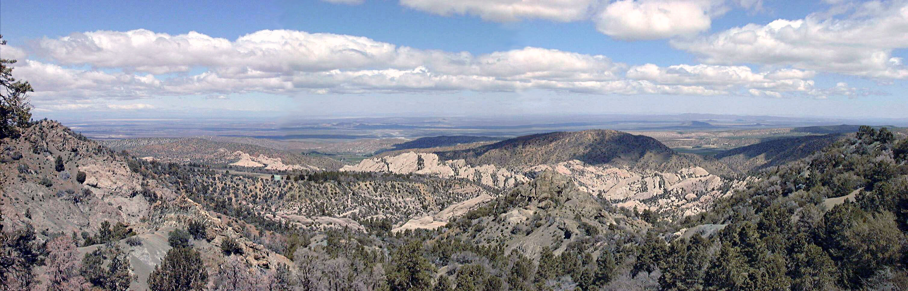
The rock coloration gets stronger the further east you go, and the HDNRT follows the sandstone all the way to Vincent Gap. You cross 2 red saddles on the way that are adjacent to large red uplifts. Below is a pic from a point just west of Devil's Chair (3 old pics, early digital, stitched), you can see the darker red rocks on the right edge.
There are a couple nice swimming holes to find if you wander around the various 'narrows' down in the bowl.
I nearly summited Williamson from Punchbowl once. Viewing JeffH's final picture, my route went up the ridge from right side to left. I got to where it joins the ridge from the left, found a chunk of old plane fuselage, and felt the onset of flu. Called it a day and descended pronto. My ascent route was excellent! Had some 'conglomerate knife edge' among manzanita and white fir. Otherwise almost no bushwhack, just gentle open slopes. There is (was?) a great campsite about 2100m/7000ft on a flat saddle with fir trees to shade.
There are several documented rock climbing routes, and lots of opportunity to get hurt. It's generally bad rock, but has good layers. I think the county may have forbade bolt replacement, so all the belay stations are aging StarDryvn with angle iron...or aluminum! :O
The rock coloration gets stronger the further east you go, and the HDNRT follows the sandstone all the way to Vincent Gap. You cross 2 red saddles on the way that are adjacent to large red uplifts. Below is a pic from a point just west of Devil's Chair (3 old pics, early digital, stitched), you can see the darker red rocks on the right edge.
There are a couple nice swimming holes to find if you wander around the various 'narrows' down in the bowl.
I nearly summited Williamson from Punchbowl once. Viewing JeffH's final picture, my route went up the ridge from right side to left. I got to where it joins the ridge from the left, found a chunk of old plane fuselage, and felt the onset of flu. Called it a day and descended pronto. My ascent route was excellent! Had some 'conglomerate knife edge' among manzanita and white fir. Otherwise almost no bushwhack, just gentle open slopes. There is (was?) a great campsite about 2100m/7000ft on a flat saddle with fir trees to shade.