
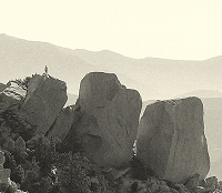
East Fork to Allison Mine, Allison Gulch, and Heaton F trail

Nice TR. Nice to know that the Allison Mine area is still accessible.
I've been to the Allison several times. Only once did I try to find the Stanley Miller Mine trail -- perhaps 17 or 18 years ago. At the time, I could see a faint trace, just a slight diminuation in the brush. I followed it for a while, maybe 5 minutes, but it was so overgrown that it was a continuous bushwhack, a bushwhack that required me to use a lot of force to bull my way through the interlocking bushes. I gave up, thinking to myself, this will take days to get to the mine and it won't be much fun. At the time, I had hoped that the trail to the Stanley-Miller would be in about the same shape as to the Allison Mine. No such luck.
I'm not really surprised to hear that the trail is no longer discernable at all. I think the fact that a) the Allison is written up in Robinson's Trails of the Angeles and b) that the Allison is far more accessible than the Stanley-Miller has kept the route to the Allison open whereas the route to the Stanley-Miller is completely gone.
The Stanley-Miller is now a steep, difficult cross country land nav challenge. How soon are you going?

I am quite tempted at making an attempt to explore that former trail, but I'll wait. First I'll try to get to Stanley Miller from the East Fork. Looks like 2 old trails head up, and I've read some stuff of people getting there (including you, I think).Hikin_Jim wrote: The Stanley-Miller is now a steep, difficult cross country land nav challenge. How soon are you going?
That will be a backpacking trip. Heat up the east fork and camp out at one of those campgrounds around Narrows / Iron Fork (I don't know anything about them yet, have to look up), and check out the trail from there. I'll wait until the night temps heat up a little bit, then plan that trip.
I think the approach from the E Fork is the best approach. That's how I got to the mine the time I went. I went on the northernmost trail. I really couldn't find the trail and just went on a very steep scramble over rock and through brush. Taking a fairly direct line, I did find the mine amidst the brush by seeing a chimney sticking out of the brush. Finding the mine is not guaranteed. The northernmost route is the shortest to the mine, and depending on your route, perhaps the simplest in terms of land nav.Zé wrote:I am quite tempted at making an attempt to explore that former trail, but I'll wait. First I'll try to get to Stanley Miller from the East Fork. Looks like 2 old trails head up, and I've read some stuff of people getting there (including you, I think).Hikin_Jim wrote: The Stanley-Miller is now a steep, difficult cross country land nav challenge. How soon are you going?
There is an old trail camp that was at one time maintained by the USFS in the area of the confluence of the SG River and Iron Fork. The flat spot is of course still there, but any maintainence is long gone. I don't know what kind of shape it's in. I'll try to dig out my old map that shows the location of the trail camp. I may be able to scan it and post it.Zé wrote:That will be a backpacking trip. Heat up the east fork and camp out at one of those campgrounds around Narrows / Iron Fork (I don't know anything about them yet, have to look up), and check out the trail from there. I'll wait until the night temps heat up a little bit, then plan that trip.
-
Sewellymon
- Posts: 97
- Joined: Tue Feb 12, 2008 8:55 pm
i recall a stream runs near the Allison Mine? Is this possible a backpacking/ overnight destination as an out-and back? Any flat spots suitable for a comfy bivy near water?
I've camped by the Allison Mine in a flat spot near the mine. I drank the water in the creek that runs down Allison Gulch. It tasted a little "minerally" to me, but no big deal.Sewellymon wrote:i recall a stream runs near the Allison Mine? Is this possible a backpacking/ overnight destination as an out-and back? Any flat spots suitable for a comfy bivy near water?
Cool thing about my old blog is people related to the history of these mountains still comment on it, check out this one:
"Nice article. I am the great-grandson of John James Allison who discovered the gold. My mother has the letter he sent to my great-grandmother telling her the gold discovery and how he would travel to Los Angeles to assemble the family for mining the claim. My grandfather, George Dewey Allison, worked the mine. They lost the gold vein due to a fault and never found it again.
Two weeks before my grandfather died, he told me the source of the gold in the San Gabriel River has never been found. He was thinking of that until the end. (I have two gold pans that were his)
Thanks again."

-
Chicken Legs
- Posts: 33
- Joined: Fri Oct 19, 2007 12:04 am
very cool personal side of the story. It wasn't that long ago...
I need to get the Alison Mine completed on my list.
This was an old post wonder what the trail is like now?
I need to get the Alison Mine completed on my list.
This was an old post wonder what the trail is like now?
-
CrazyHermit

- Posts: 343
- Joined: Mon Sep 07, 2015 1:03 pm
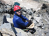
Inside the lower tunnel. This mine has three levels and multiple smaller mines outside the upper level.
The wooden structure on the left is an ore chute, the catch gate is detached and laying on the ground.
The wooden structure on the left is an ore chute, the catch gate is detached and laying on the ground.

Sweet! Where are the other entrances? I've been to this mine a few times, but never went looking for the others.CrazyHermit wrote: ↑Inside the lower tunnel. This mine has three levels and multiple smaller mines outside the upper level.
The wooden structure on the left is an ore chute, the catch gate is detached and laying on the ground.
-
CrazyHermit
- Posts: 343
- Joined: Mon Sep 07, 2015 1:03 pm
The tunnel you entered from the front is the main level. There's one below that that can be accessed from the streambed, and another upper level that can also be accessed from the streambed. In addition, if you walk through the main level and veer left you can climb up and out through a side hole (carefully). Once you get outside you'll be in an area I call the Amphitheater of Mines, where there are multiple smaller diggings.
You can see some photos of the side portals on my website. http://www.secretmines.com/p/allison-mine.html
You can see some photos of the side portals on my website. http://www.secretmines.com/p/allison-mine.html
-
CrazyHermit
- Posts: 343
- Joined: Mon Sep 07, 2015 1:03 pm
There's also a lost tunnel far below the others, at the base of a waterfall down the gulch.dima wrote:Sweet! Where are the other entrances? I've been to this mine a few times, but never went looking for the others.CrazyHermit wrote: ↑Inside the lower tunnel. This mine has three levels and multiple smaller mines outside the upper level.
The wooden structure on the left is an ore chute, the catch gate is detached and laying on the ground.
It's full of water with a low entry and I don't know of anyone who's actually been inside.
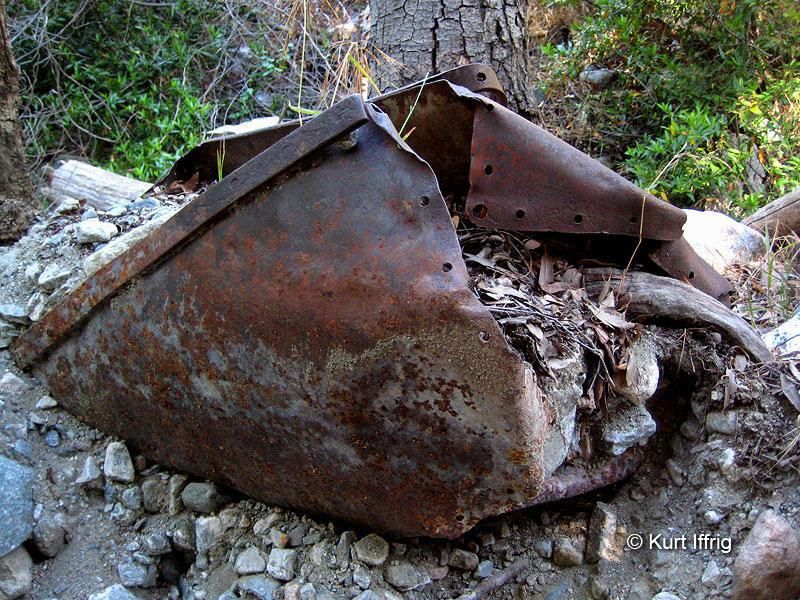
In all likelihood this is the tunnel the mine cart in Allison Gulch washed down from
(there's another one on top of the San Gabriel Dam)
This was probably the first mine the Allisons dug before they started working the area above the ball mill.
They also worked the East Fork prior to starting their mine and even did some mining down in Mexico.
